Skirting the Mississippi River, via the Louisiana Great River Road, to where it spills into the Gulf of Mexico, is a ride I’ve wanted to do for quite some time. Now, a little over two months after I walked across the mighty Mississippi’s headwaters in Itasca, MN, I was going to complete the loop to stand at its mouth. I left my parents house in Houma, just after sunrise, to embark on the 125-mile, one-way, route that would first take me north towards New Orleans, then east to pick up the Great River Road, and ultimately south through the towns of Buras and Venice through the Mississippi Delta. The fascinating ride, complete with historical stops, took me to the southernmost point in Louisiana accessible via paved road.
As you can see from the Google map directions, the mouth of the Mississippi is much farther south than the port of New Orleans (contrary to popular belief). There are several towns along LA-23 on the way to where the Mississippi River ultimately spills into the Gulf of Mexico.
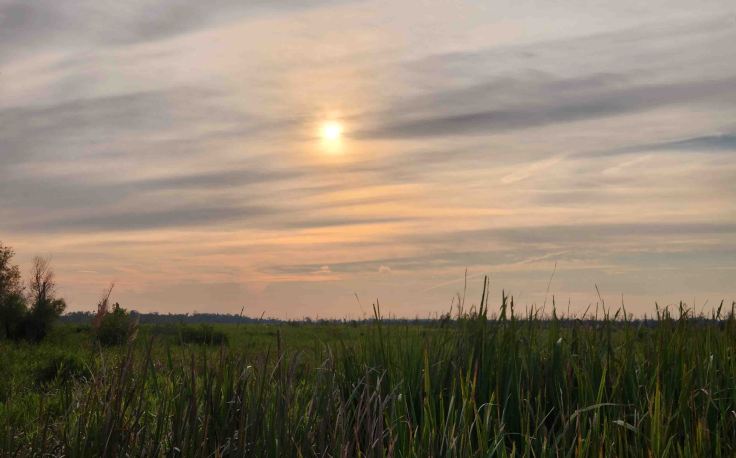
Sunrise over the marsh that separates LA-182, on the outskirts of Houma, from Lake Fields, west of Lockport, LA.
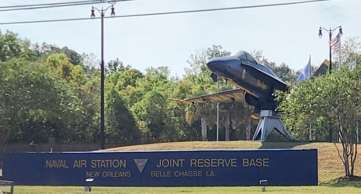
After my discharge from active-duty service in the Navy, I worked as an Electrical and Environmental Technician on F-15 aircraft while serving in the Louisiana Air National Guard. I augmented my GI Bill by completing Unit Training Assembly (UTA) drills at Naval Air Station Joint Reserve (NAS JR) Base Belle Chase, LA, and by being activated for two-week deployments, including one to Iceland in 1999.
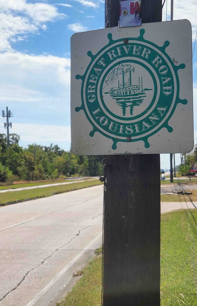
I picked up LA-23, a section of the Great River Road in Louisiana, just after NAS JR Base Belle Chase. It is part of a 3,000-mile National Scenic Byway that traverses ten states. “It is a well-marked series of different roads and highways that roughly follow the winding course of the Mississippi River. All along the Great River Road, travelers will find white signs displaying the green pilot’s wheel logo. The familiar pilot’s wheel symbol (iconic representation of Riverboat travel) denotes which roads are part of the designated route…which has been selected for its natural, cultural, historical, recreational, and scenic properties.” -Great River Road website
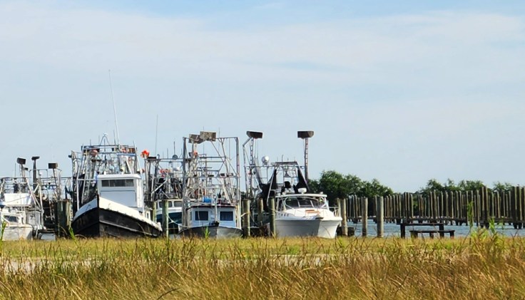
Shrimp boats docked at a safe harbor in Empire, LA.
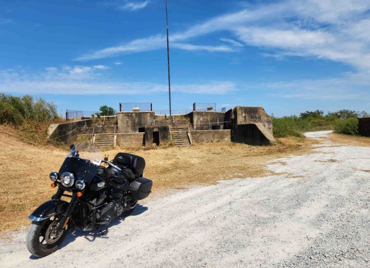
Located 70 miles below New Orleans on the west bank of the Mississippi River, Fort Jackson, a brick star-shaped fort, was constructed between 1822-1832. The “nearly two-century old stronghold…was the site of a ferocious Civil War battle with the Union Navy. The fortress, occupied by Confederate troops, failed to stop the Union advance… [resulting in] the surrender of New Orleans and Union control of the lower Mississippi River.” -Heart of Louisiana website
Unfortunately, multiple hurricanes over the years have caused significant damage to the brick walls and foundations, so visitors can no longer go inside the fort. You can still access fort structures overlooking the Mississippi River though.
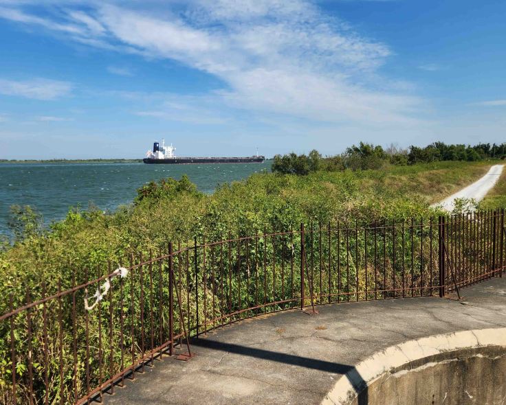
There is a great view of the Mississippi River from an overlook at Fort Jackson. “Fort St. Philip is located directly across the Mississippi River from Fort Jackson. The forts are located on a bend in the river, which required a slow and difficult maneuver for naval ships trying to sail upstream and avoid cannon fire. In the War of 1812’s Battle of New Orleans, Fort St. Philip successfully halted the advance of the British Navy on the Mississippi River.” -Heart of Louisiana website
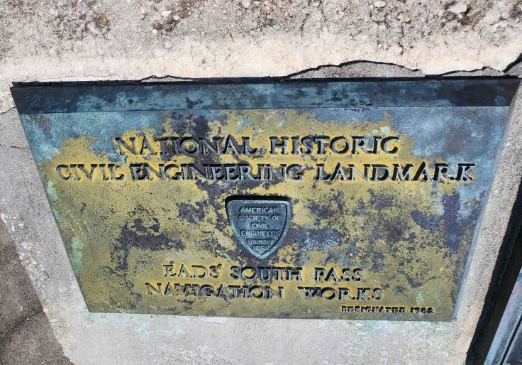
At the Fort Jackson overlook, there is a fascinating historical marker with the story of Eads’ Jetties. In the late 1800s, the Army Corps of Engineers’ efforts to dredge the ever-forming sandbars that were blocking shipping into the Port of New Orleans were failing miserably. An intrepid shipbuilder from St. Louis, named James Buchanan Eads, won a contract to construct wing dikes, perpendicular to current flow at South Pass (18-miles south of Fort Jackson where the Mississippi River branches into the Gulf of Mexico), which created a self-scouring channel. This spurred a bitter rivalry between Eads and the Army Corps of Engineers. Upon completion in 1879, his jetties created a 30-foot channel which contributed to the Port of New Orleans advancing from the 9th, to the 2nd, largest port in the United States. Almost 100 years after besting the Army Corps of Engineers, his jetties were designated as a historical landmark. –PBS website and historical markers
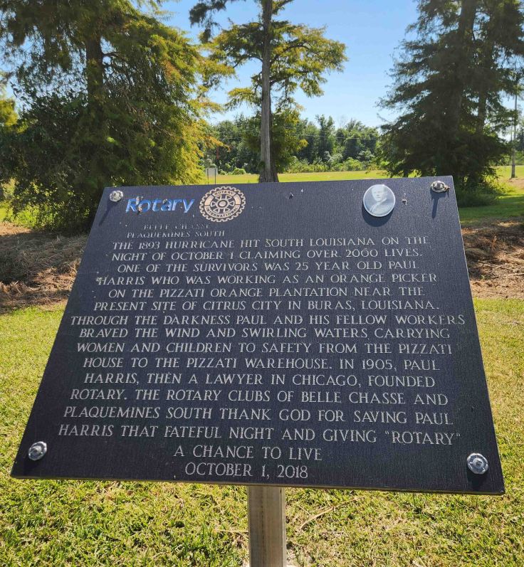
Unfortunately, the Fort Jackson Museum was closed on the day I visited, but I stumbled upon this interesting history about the Rotary Club in the parking lot.
Scenery along LA-23 in Venice, LA
Great illustration via Google maps directions of how LA-23 follows the Mississippi River until paved travel is no longer possible, then veers to the southwest, ending at a sign marking the “southernmost point in Louisiana.”
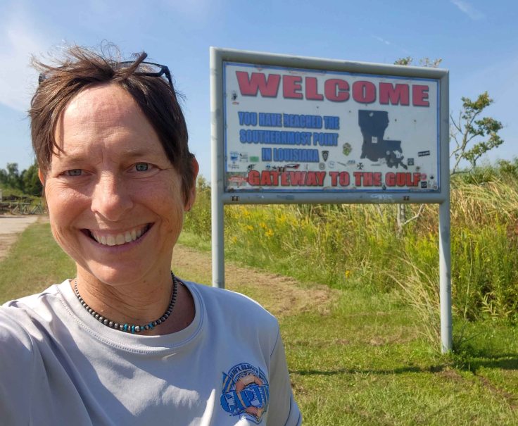
Though the surfaced road ends here at the “southernmost point in Louisiana” sign, oil and gas companies maintain a private, gravel road beyond this point.
Satisfied with closure of my Mississippi River adventure on this trip, I pointed my bike north and made the roughly two-hour journey back to my parents’ house in Houma. Even though I had lived in south Louisiana for a large part of my adult life, I had never actually been this far south along the mighty Mississippi. You can learn so much by playing tourist in your own backyard!
The clock was ticking away the time I had left for my journey back to NC, so after a little more time on Bayou Blue, it was time to start making my way home.
We took almost the same trip to the end of Louisiana, last weekend.
Thanks for the additional information that we did not pick up that day.
Greetings Jon and family from Denmark.
I currently live in Southwest Colorado, but I am from lower Plaquemines Parish. I have many a fond memories of hanging out at Fort Jackson over the years. It’s a shame the state and parish hasn’t maintained it like they should have. And thank you so so much for pointing out the obvious…………….the river doesn’t end in New Orleans.
I was surprised by how many people I met during my travels that thought the Mississippi River ended at New Orleans. But in their defense, I’m pretty sure most people in south Louisiana have no idea that the River’s headwaters start at Lake Itasca, Minnesota.
It was the best place in the world to grow up in. Buras La. U knew everybody & everybody knew who u were & who your family was & where u lived . Related to half of them. What wonderful memories
Yep, Joe Joe Twiner is correct. I too grew up in Buras and knew Joe Joe and everyone down there. Fort Jackson was open to the public and it was a meeting place for teenagers. You are also dead on with reference to people not knowing there is land below New Orleans. When I tell people in Houston, Texas (where I live now) that I’m from a little town South of New Orleans they always say they didn’t know there was anything below New Orleans. Safe travels on the bike! Thanks for the blog.
I am reading this 3 years later than everyone else, what up Joe Joe and “Peanut”, I am afraid this piece of literature will be invaluable in the very near future, so much of our Parish is washing away, I feel it will be virtually impossible to make the trek to Venice by automobile in the next 25 to 30 years. I really enjoyed taking this trip down the Parish with you guys.
I’m so glad you enjoyed the walk down memory lane. I’m thankful to have had the opportunity to experience this disappearing journey before it totally vanishes 😥
What up Big Fig? (aka Figgie, I think??). Growing up Down the Road (DTR as it’s now called) was something unique that not everyone may have enjoyed but I would do it all over again. Hunting, fishing, shrimping, cajun food every day, knowing everyone in the town, simple life, Fort Jackson every weekend partying with friends……take me back!


We took almost the same trip to the end of Louisiana, last weekend.
Thanks for the additional information that we did not pick up that day.
Greetings Jon and family from Denmark.
LikeLiked by 1 person
That’s so awesome that y’all did that trip! Happy holidays to you and your family 😀
LikeLike
I currently live in Southwest Colorado, but I am from lower Plaquemines Parish. I have many a fond memories of hanging out at Fort Jackson over the years. It’s a shame the state and parish hasn’t maintained it like they should have. And thank you so so much for pointing out the obvious…………….the river doesn’t end in New Orleans.
LikeLiked by 1 person
I was surprised by how many people I met during my travels that thought the Mississippi River ended at New Orleans. But in their defense, I’m pretty sure most people in south Louisiana have no idea that the River’s headwaters start at Lake Itasca, Minnesota.
LikeLike
It was the best place in the world to grow up in. Buras La. U knew everybody & everybody knew who u were & who your family was & where u lived . Related to half of them. What wonderful memories
LikeLiked by 1 person
Bayou Blue was the same way!
LikeLike
Yep, Joe Joe Twiner is correct. I too grew up in Buras and knew Joe Joe and everyone down there. Fort Jackson was open to the public and it was a meeting place for teenagers. You are also dead on with reference to people not knowing there is land below New Orleans. When I tell people in Houston, Texas (where I live now) that I’m from a little town South of New Orleans they always say they didn’t know there was anything below New Orleans. Safe travels on the bike! Thanks for the blog.
LikeLiked by 1 person
Thank you! I love bringing awareness to these “hidden” gems.
LikeLike
Yeah, it’s at its confluence with the Missouri River north of St. Louis
LikeLike
?
LikeLike
Looks like a great trip!
LikeLiked by 1 person
Big Fig
May 9, 2025
I am reading this 3 years later than everyone else, what up Joe Joe and “Peanut”, I am afraid this piece of literature will be invaluable in the very near future, so much of our Parish is washing away, I feel it will be virtually impossible to make the trek to Venice by automobile in the next 25 to 30 years. I really enjoyed taking this trip down the Parish with you guys.
LikeLiked by 1 person
I’m so glad you enjoyed the walk down memory lane. I’m thankful to have had the opportunity to experience this disappearing journey before it totally vanishes 😥
LikeLike
What up Big Fig? (aka Figgie, I think??). Growing up Down the Road (DTR as it’s now called) was something unique that not everyone may have enjoyed but I would do it all over again. Hunting, fishing, shrimping, cajun food every day, knowing everyone in the town, simple life, Fort Jackson every weekend partying with friends……take me back!
LikeLiked by 1 person