Since I traveled via state and national scenic byways as much as possible while I made my loop through the south, it’ll be easiest to group my story-telling in the same way. If you’re not a rider, don’t worry, there were LOTS of sites along the way that had nothing to do with motorcycles or rides. If you are though, I’ve included some highlights that I hope you’ll find interesting if you’re considering doing this ride.
From Suches Loop in Georgia, I made my way to Fort Payne, Alabama where I staged for a few nights so I could take in as much of the Lookout Mountain Scenic Parkway as possible. Its 93 miles span three states (Georgia, Tennessee, and Alabama) and includes everything from National Park Service units, to state parks, to Trail of Tears sites, to gnarly roads, to water falls, to country music icons – this route has it all!
Click on the map to go to the official brochure of the Lookout Mountain Scenic Parkway, which includes maps you can enlarge and highlights along the route.
I’ll start from the northern terminus (the right side of the map above). I had visited several sites within the Chickamauga and Chattanooga National Military Park (which spans Georgia and Tennessee) back in May on a 4-wheel trip, so I didn’t revisit them on this excursion. However, since the Parkway is named after Lookout Mountain, which is included within the National Battlefield, I figured I’d include a few pics and some info in this post.
The Confederates controlled Chattanooga early in the Civil War (1863), but the Union was determined to take it. “The small city lay on the banks of the Tennessee River where it cut through the Appalachian Mountains, allowing four major railroads to converge.” Taking the town would mean crippling Confederate supply lines and “striking at the heart of the Confederacy.” Fighting at Chickamauga, Lookout Mountain, and Chattanooga finally ended in a Union victory, but at a cost of over 12,000 American lives. (NPS brochure)
From Point Park on Lookout Mountain, you can clearly see the land area carved out by the Tennessee River, known as Moccasin Bend. Thirty years before the Civil War came to the Chattanooga region, the US Army (including some future Union and Confederate leaders), forced the area’s Cherokees to move to Indian Territory (Oklahoma) on what became known as the Trail of Tears.
Though not officially part of the Lookout Mountain Scenic Parkway, I took a little side trip to Russell Cave National Monument near Bridgeport, AL. “This cave shelter, its cooling stream, and the surrounding forest provided for America’s earliest inhabitants for hundreds of generations. Yet only in the 1950s were the ancient clues of life at this site unearthed…when archeologists uncovered a large quantity of artifacts representing over 10,000 years of use in a single place.” (NPS brochure and website)
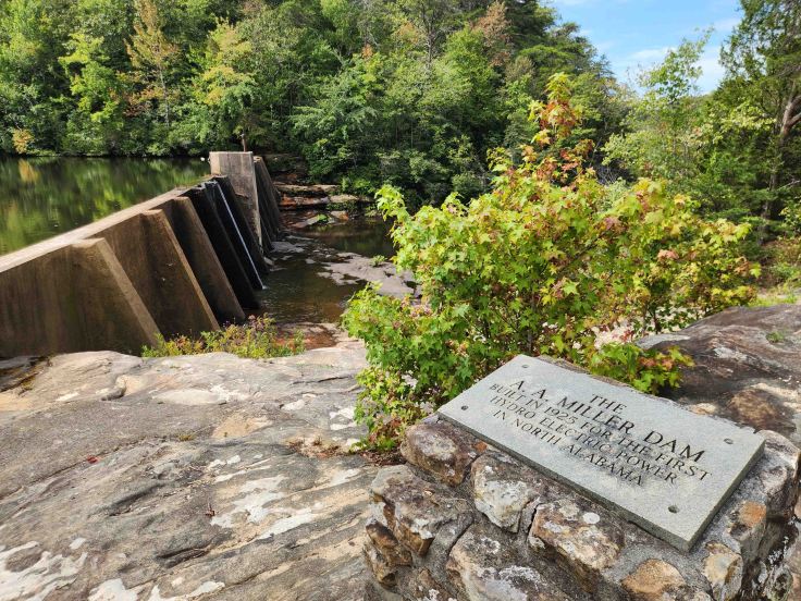
This 20-foot-high dam above Desoto Falls, built by Arthur Abernathy Miller in the mid-1920s, generated electrical power for Fort Payne, Mentone, Valley Head, Collinsville, Alabama and Menlo, Georgia. The dam is now enclosed within the boundaries of Desoto State Park in Mentone, AL. (Alabama State Park website)
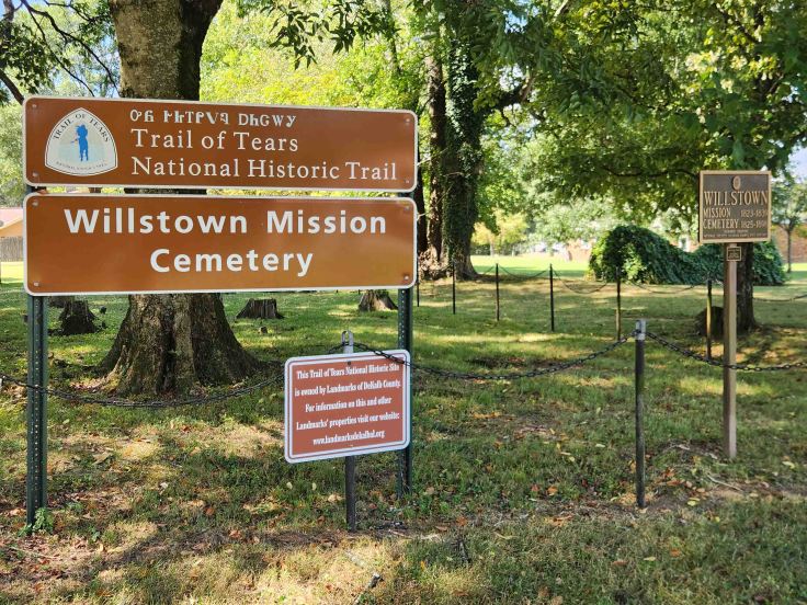
Fort Payne is home to several Trail of Tears historical sites, such as Willstown Mission Cemetery, which sits on the site of a former mission/school for local Cherokee, established by leaders of the tribe in 1823. The mission/school was shut down after the forced removal of the Cherokee (now known as the Trail of Tears to Oklahoma) in 1838. The cemetery is thought to contain the remains of 41 Cherokee who died in camp at Fort Payne as they were held for their forced removal. Another area historic Trail of Tears site is the Fort Payne Cabin, which is made up of remains of one of 20 removal forts (stockades) established in Alabama, Georgia, and North Carolina, that was the confiscated home of a Cherokee known as Spirit the Preacher (aka John Huss).
The Lookout Mountain Scenic Parkway runs through the Little River Canyon National Preserve outside of Fort Payne, AL. The rim parkway, which shares the same name as the preserve, parallels the Little River, most of which flows atop Lookout Mountain and rises 500 feet from the edge of the cliffs to the river bottom in some places. (NPS brochure)
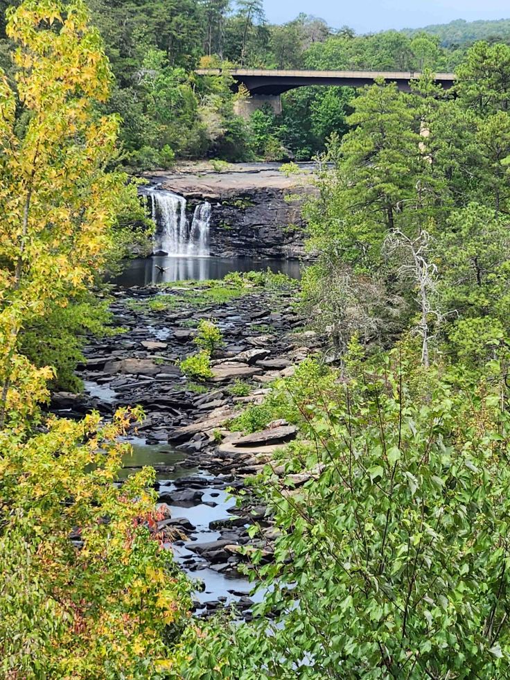
One of the many stunning views from overlooks along the parkway – Little River Falls.
The official 11-mile route for the Little River Canyon Rim Parkway is the section of AL-176 that runs through the preserve. There are lots of overlooks providing gorgeous views of waterfalls, canyons, and of course, the river itself. The parkway ends at Eberhart Park, but there’s an option to continue following the river through the park for another 11 miles via Cherokee County Road 148/275 to Canyon Mouth Park . . . if you dare! A badly deteriorated and crumbling road, with steep grades and lots of gravel, it was no joke and I was relieved to pop out onto AL-273 at the end of it.
Little River Falls, as viewed from an observation deck on the opposite side of the canyon from the parkway. The observation deck is easily accessible via a short trail from a parking and picnic area. This was my second visit to the falls this year, and there was a noticeable decrease in volume of streamflow on this trip compared to the one in the spring. Still a sight to behold!
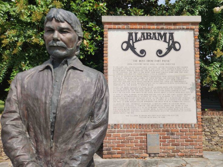
This statue and sign is part of a downtown commemorative park dedicated to the country music band “Alabama,” which hails from Fort Payne. This was to become the first of several music-themed sites along my journey.
This whole area is loaded with history and natural beauty, it’s definitely a place that deserves a return visit!


Leave a comment