Reenergized from my stop in Hot Springs, I pointed my bike west and jumped onto US-270 to ride the northern segment of a local route known as Diamond Run. The route gets its designation from a state park on the southern leg whose name is a nod to the precious mineral for which Arkansas was the first to mine – diamonds! So that’s why there’s a diamond on the state flag! I didn’t stop at any diamond mines, but I certainly enjoyed riding broad sweeping curves through the Ouachita National Forest on my way to Mena to pick up the Talimena Scenic Drive Byway.
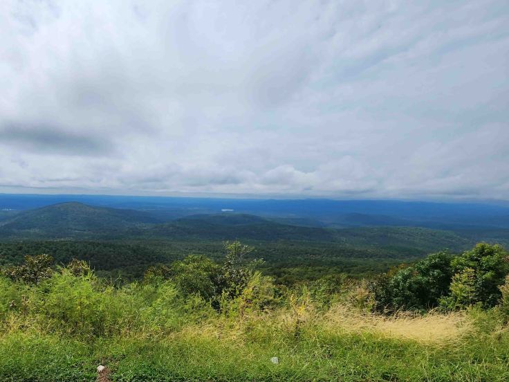
Talimena Scenic Drive is a 54-mile National Scenic Byway that passes over Winding Stair and Rich Mountains and through Ouachita National Forest. Talimena is a combination of the byway’s terminus town names – Talihina, Oklahoma on the west, and Mena, Arkansas on the east.
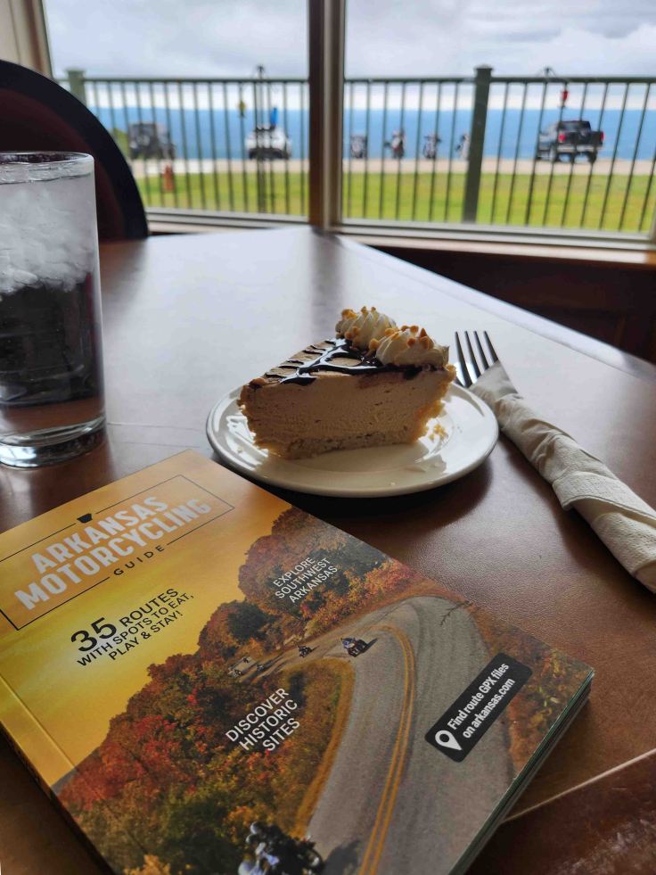
The Arkansas Motorcycling Guide is a great source of riding information. Staci Wilt, creator of Ride to Food and one of the few travel bloggers that I follow, contributed several dining recommendations to the Arkansas guide. Her endorsement for pie at the Queen Wilhelmina State Park Lodge was spot on! The peanut butter version, and the view from my table, were amazing!
About 20 miles west of Queen Wilhelmina State Park, I stopped at the border of Arkansas and Oklahoma to get a pic by the Talimena Scenic Drive sign. Although I’ve been a member of the Harley Owners Group (HOG) since I bought my first Harley-Davidson motorcycle back in 2006, I have never really been active with chapters or events. I do love good route planners though, so after my big trip last summer, I looked into the HOG “50 Rides 1 Nation Challenge” that Larry, one of my Bunk-a-Biker hosts, told me about. It’s a lifetime challenge that designates a check point at one scenic byway, or famous motorcycle ride, in each state by which you take your pic with the challenge guide. I had already visited almost 20 of the rides before I started participating, so I guess I’ll just have to revisit them in the future! My total for this year (including Talimena Scenic Drive for Oklahoma and the Pig Trail for Arkansas) is 13. Not a bad “official” start!
The Talimena Scenic Drive reminded me of the Blue Ridge Parkway in North Carolina and Virginia – just a two-lane road through the mountains with gorgeous overlooks into the valleys below.
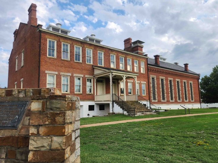
I turned north at the end of the Talimena Scenic Drive and rode a couple of hours through Oklahoma before crossing back into Arkansas to visit Fort Smith National Historic Site. The original fort was built in 1817 in response to the westward push of the U.S. boundary into Indian Territory after the Louisiana Purchase. The continued forced resettlement of numerous eastern tribes past the western banks of the Mississippi River caused much strife amongst newly arriving, and already established, indigenous nations.
In addition to “keeping the peace” between native Americans, Fort Smith’s history includes time as an important supply depot for forts built farther west during frontier days and during the Civil War, as a Federal Court for the Western District of Arkansas, and as one of the most notorious jails of its time, nicknamed “Hell-on-the-Border,” until 1896.
I overnighted in Fort Smith, then rode towards the iconic route known as the Pig Trail. I had attempted this ride before with some of my CVMA family en route from San Antonio, Texas to Kansas City, Missouri in 2015 for the national meeting, but most of it was closed for road construction. I was excited to get another attempt on this trip!
Official description of the Pig Trail Scenic Byway (Arkansas Dept. of Transportation website): “Beginning in the southeast corner of the Ozark National Forest near I-40, the byway extends north along AR-23 for 19 miles to AR-16 at Brashears. With its many steep inclines and sharp curves, driving the Pig Trail may be likened to riding a roller coaster. Trees crowd the roadside, creating a shady corridor during the summer in some areas and display stunning fall color. Very little development has occurred along this route, offering travelers a glimpse of the Ozarks that would have been familiar to the early settlers.”
I stopped at this scenic overlook to take in the view. I pulled up a little behind a couple trying to take a selfie with their bike. I parked and offered to take the photo for them, then we chatted for a bit. Turns out he’s a professional photographer and offered to reciprocate my generosity with a pic of my own.
From the Pig Trail, I continued north and picked up US-62 towards Pea Ridge National Military Park and on to the town of Eureka Springs.
Just outside of Garfield, Arkansas and below the Missouri state line, Pea Ridge National Military Park is home to a 4,300-acre battlefield where “the most pivotal Civil War battle west of the Mississippi River” occurred. The battle fought on Pea Ridge by over 23,000 Soldiers, resulted in Missouri remaining in the Union and “politically neutral,” though it provided men and supplies to both sides throughout the war. The critical attacks and counter-attacks happened in the Elkhorn Tavern area (notice the elkhorns on the roof of the tavern in the photo). (NPS website and brochure)
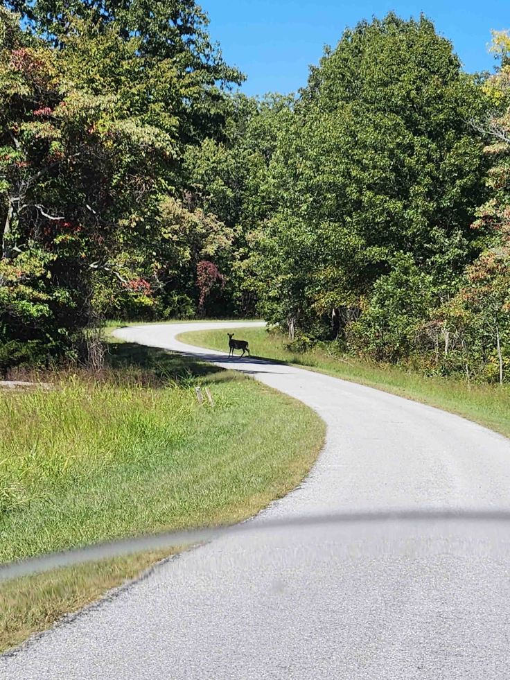
As usual, I watched the film at the Visitor Center to get the history and some context about the area and battle before touring the park. I jumped onto Military Park Road, which circles the major parts of the battlefield, to take the self-guided tour. I had just resumed the tour after stopping to read a few historical placards when I looked up ahead and saw this silhouette in the road. It stood absolutely motionless as I put my feet down and grabbed my phone to snap this photo. It was a bit of a stand-off for a few minutes until I honked my horn to snap it out of its fixation, then it bolted for the woods. It’s always fascinating to see history co-existing in the present via nature and wildlife.
It was getting late and time to find a place for the night. I resumed my travel along US-62, this time eastbound on one of the primary routes to Eureka Springs, which was full of twists and turns. Given my aversion to large crowds, I had planned my arrival to one of the most motorcycle friendly cities in the country for the weekend to be after the nearby town of Rogers had hosted what’s billed as “the world’s largest charity motorcycle rally” – Bikes, Blues and BBQ.
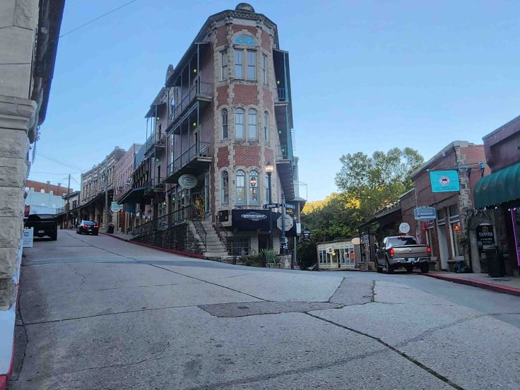
The Flatiron Building is sandwiched between Spring and Center Streets and has become the most photographed building in downtown Eureka Springs, as well as the defacto iconic symbol for the city. The structure is balanced on somewhat of an island between the two steep streets, hinting at the fabulous hilly riding that surrounds the township. The original building was constructed in 1880, then destroyed by fire 10 years later. The second version of the building was also destroyed by fire, so the current iteration was built entirely of concrete and brick in 1987. So far, so good!
With the rally crowds departed, finding a room and places to eat was not a problem! I ended up staying at the New Orleans Hotel in the heart of downtown, where I was treated to this fabulous view above the streets of the city.
The last thing I did before settling into bed for the night was look through my Arkansas Motorcycling Guide to identify the next day’s route. Oh look, a loop into Missouri . . .


Leave a comment