Even though I no longer have professional obligations that limit my travel, I do still have personal commitments which I sometimes prioritize over touring. Last year, the interment of ashes of a good friend served as a backstop for my cross-country trip. This year, the joyous occasion of another good friend’s wedding was the catalyst to bring me back to North Carolina at the beginning of October. Truth be told, the shortening and chilling of days certainly contributed to my desire to bring me closer to hearth and home. With a little less than a week to make it back for the nuptials, I continued on to East Tennessee, the official designation for the area that spans roughly from the Cumberland Plateau in the west, to the Great Appalachian Valley in the east, and separated from the rest of the state by the line that divides Eastern and Central Time Zones.
First stop was a ride and short hike to Lilly Bluff Overlook on the Obed National Wild and Scenic River. Added to the National Park System (NPS) in 1976, lands within the Obed Wild and Scenic River are jointly managed by the NPS and the Tennessee Wildlife Resources Agency. As you can see in the pic of the approach to the overlook, the surrounding forest, made up of oak, hickory, poplar, pine, and hemlock, were just starting to transition to fall colors.
Abundant game sustained Indigenous populations, and later pioneers, seasonally along the 45-mile Obed River, but poor soil, inhospitable terrain, and isolation dissuaded long-term settlement and contributed to the undeveloped natural beauty of what is now a hub for hunters, anglers, paddlers, birders, hikers, campers, rock climbers, and other outdoor enthusiasts. (NPS brochure and Rivers.gov website)
The next stop on my East Tennessee tour was one of the sites of The Manhattan Project National Historical Park in Oak Ridge. On August 6, 1945, the world forever changed when the U.S. dropped an atomic bomb on Hiroshima, Japan, and then 3 days later, on Nagasaki. The project that resulted in the design and building of this technology was an unprecedented, top-secret program known as The Manhattan Project. The three major sites contributing to the project were in Los Alamos, New Mexico; Hanford, Washington; and Oak Ridge, Tennessee.
“Oak Ridge, Tennessee was home to several massive Manhattan Project facilities employing thousands of workers during and after World War II and was the headquarters for the project.” Numerous sites associated with the enrichment of uranium, including the K-25 plant, gatehouses, and remnants of the “Secret City” are managed in partnership by the National Park Service and the Department of Energy. Several museums throughout the city tell the story of that historic time, as well as the economic, ethical, and moral consequences in its aftermath. A very good overview of the development of the technology, as well as the town of Oak Ridge, can be seen at the Children’s Museum of Oak Ridge, K-25 History Center (photo), and the American Museum of Science and Energy.
After a full day of exploring the museums of Oak Ridge, I headed out the next morning to ride some twisty roads and sightsee my way to Cumberland Gap.
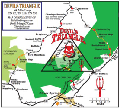
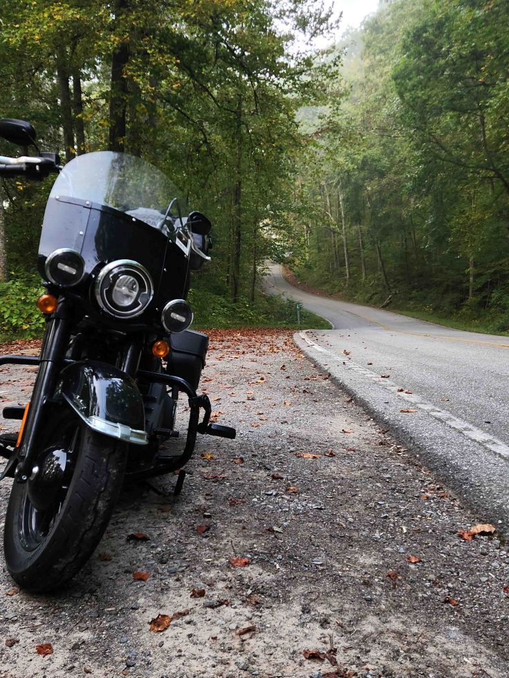
I was excited to finally get to ride the 44-mile loop north of Oak Ridge known as the Devil’s Triangle. The gorgeous sweepers, fun twisties, and tight switchbacks through the mountains of the Cumberland Plateau did not disappoint!
The early morning mist lingering roadside in the trees, and scarcity of other vehicles along the Devil’s Triangle route, made for a chilly, and some-what eerie, ride.
I detoured from the TN-116 side of the Devil’s Triangle to explore the Clinch River area. I happened upon a few folks fishing at this little park near Miller Island on the river. So serene.
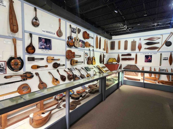
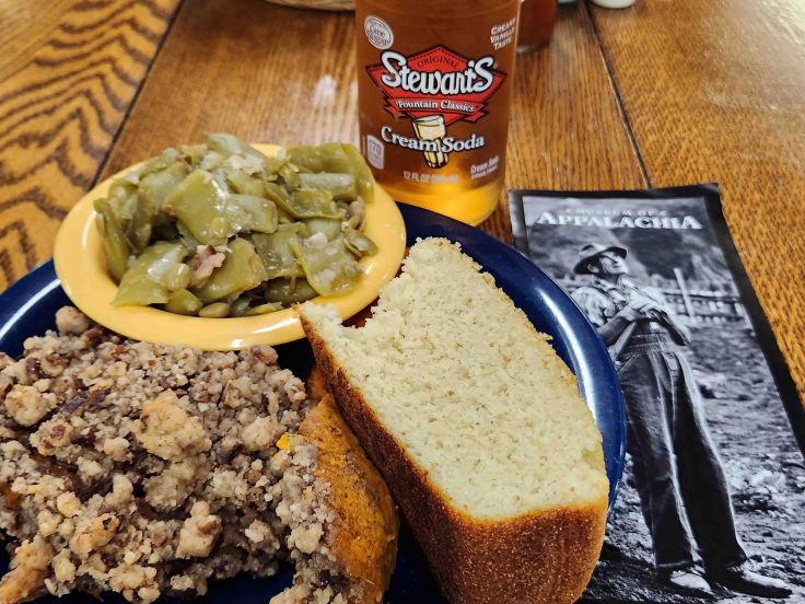
Just 30 minutes northeast of Oak Ridge resides a 65-acre living museum, “a pioneer mountain farm-village that lends voice to the people of Southern Appalachia through the artifacts and stories they left behind.” With over 250,000 artifacts, the Museum of Appalachia, a Smithsonian Affiliate, paints a holistic picture of life in the mountains, including the role of music in everyday life. “A massive collection of unusual hand-made musical instruments adorn the walls of a display that includes everything from Roy Acuff’s fiddle, to a banjo made from a hubcap.” (Museum of Appalachia website)
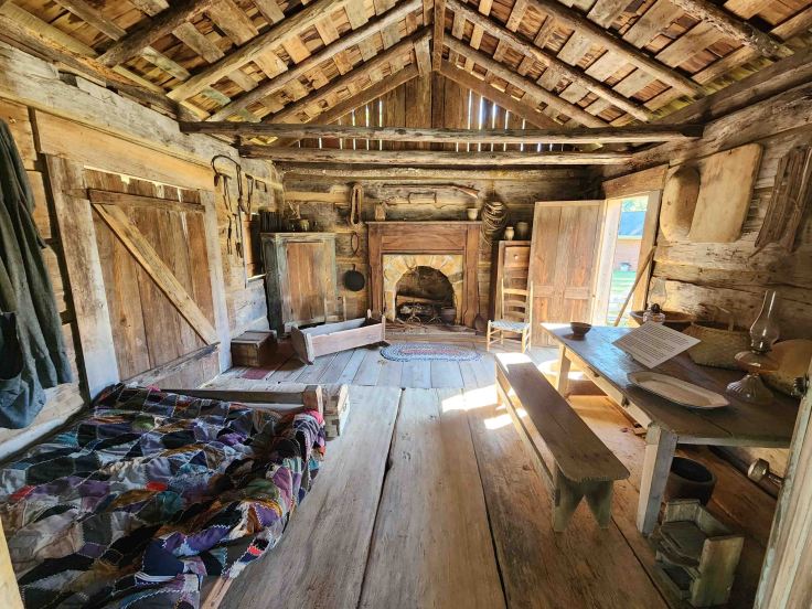
This little cabin, built circa 1800 on the Clinch River about 40 miles northeast of the museum, belonged to Wes Arnwine and wife, and is listed on the National Register of Historic Places. This structure serves as an example of what a typical Appalachian home looked life before the days of electricity. The Arnwine log cabin is one of 35 on the grounds interspersed amongst barns, farm animals, churches, schools, and gardens. (Museum of Appalachia website)
I enjoyed a Southern Appalachian style meal of green beans, sweet potato casserole, cornbread and a cream soda (I like side dishes more than fried chicken!) while listening to local musicians pickin traditional mountain instruments. It was such a great stop!
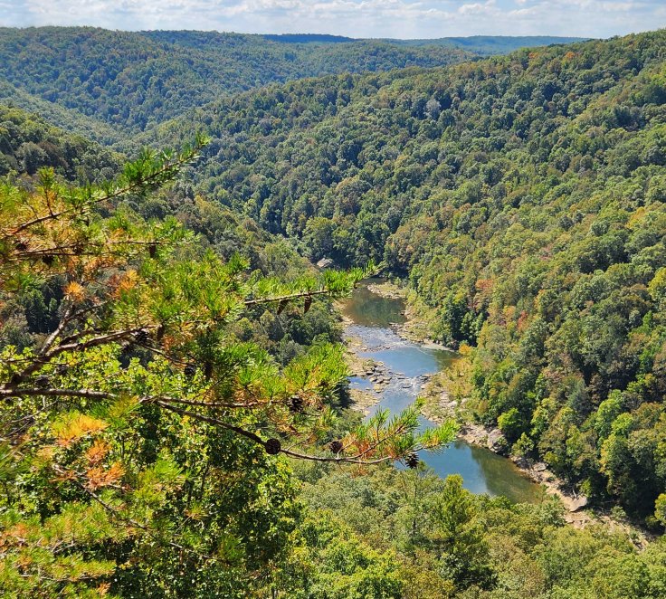
With a full belly and humming mountain tunes, I rode northwest to explore yet another river – Big South Fork National River and Recreation Area. According to the NPS brochure, “The Big South Fork River begins in Tennessee at the confluence of the Clear Fork and New rivers, flows north through a spectacular 600-foot-deep gorge, enters Kentucky, and empties in the Cumberland River.” “Rock shelters bear evidence of thousands of years of human habitation, and remnants of homesteads and cemeteries dot the landscape.” This photo was taken from the East Rim Overlook, which has a colorblind viewfinder to enhance the experience for those who have the inability to distinguish shades of red and green.
I was greeted with some of the twistiest riding of the trip so far on Leatherwood Ford Road in Big South Fork National River and Recreation Area. The portion of this road, between where it intersects with Station Camp Road on the eastern side and Brandy Creek Visitor Center, is some spectacular riding!
I was excited to start making my way towards Cumberland Gap, where I would meet a CVMA brother for a few days of riding. I had met Crash a couple of months ago when I joined him, Mongo and Top for some riding in the Banner Elk, NC area (click HEREto read about that trip). I remembered that he lived close to the Kentucky-Tennessee border, so I contacted him to see if he wanted to meet to burn up some twisty roads. Yep, he was in!
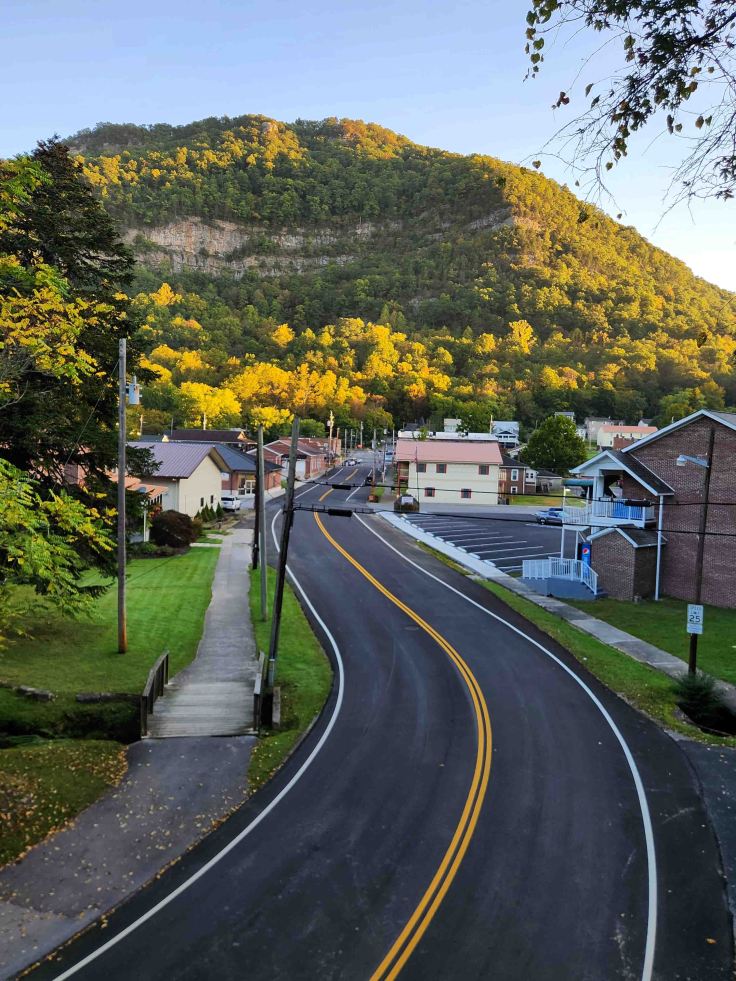
The town of Cumberland Gap is named after the natural passage through the mountains near the most scenic point of where Virginia, Kentucky, and Tennessee meet. With a population of less than 500, and situated on only a couple hundred acres of land, this little town provides the perfect leisurely spot from which to stage for exploring the nearby attractions. Lodging at the Cumberland Gap Inn provided magnificent views of the famous gap.
View of the town of Cumberland Gap from Pinnacle Overlook. If you zoom in, the building on the edge of town at a 45-degree angle and triangular parking lot is the Cumberland Gap Inn. The 4-mile twisty road from the visitor center to the overlook parking lot was a fun ride!
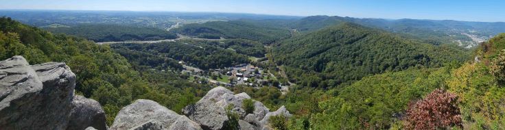
We stopped long enough at the Cumberland Gap National Historical Park Visitor Center to watch a couple of films covering the history of the area before riding up to Pinnace Overlook (click HERE to watch a 12-minute history of the area). From Indigenous peoples, to Daniel Boone and the accompanying enslaved people who helped blaze a frontier trail, to the Union and Confederate soldiers who alternatingly held the area, there are many perspectives to the history of this gap in the Appalachian Mountain range. Crash and I walked to the tri-state marker and are standing at the intersection of Kentucky, Tennessee, and Virginia in this photo.
Before long, it was time for Crash and I to part ways and head back to our respective homes. I jumped onto the East Tennessee Crossing National Byway to continue my journey east.
The 83-mile East Tennessee Crossing National Byway follows an ancient game trail that was used by both the Shawnee (in the north) and the Cherokee (in the south) known as “Warriors Path” and later dubbed “Wilderness Road” as it transitioned to a pathway led by Daniel Boone for approximately 300,000 frontier settlers. It further transitioned into a section of the “Dixie Highway,” an early 1900s effort to connect the Midwest to the south, and then became part of the legendary “Thunder Road” moonshine route during Prohibition. So much history on this route!
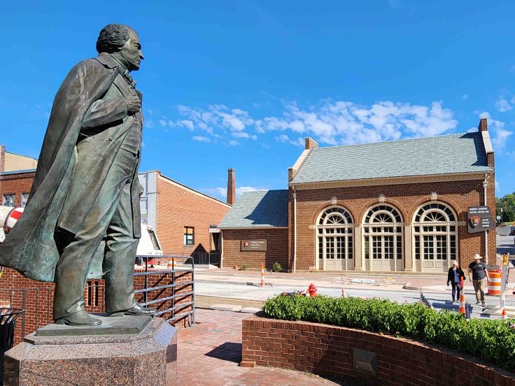
My last sightseeing stop before reaching home was the Andrew Johnson National Historic Site in Greenville, Tennessee. Comprised of the 17th president’s early home, tailor shop, and burial site, this park highlights the life of a man whose presidency oversaw the purchase of Alaska from Russia in 1867.
After a little over a month on the road, I pulled into my garage just in time to settle in back home and attend Ryan and Melissa’s wedding. With the days getting noticeably shorter, and chillier, I was happy to be back home for the end of long-distance riding season.


Leave a comment