
As I was planning my 2022 summer cross-country motorcycle trip, I was frustrated by the lack of a single website that listed iconic and scenic motorcycle rides, by state, that included links to websites, maps, and descriptions incorporating actual start and end information. Numerous public and private entities publish information on scenic drives/byways, but there did not seem to be a single place to go that connected national and state byways, county township scenic drives, AND named/iconic/local favorite motorcycle rides. If you know of one like this that incorporates local favorites and/or named motorcycle rides, as well as national and state byways for the whole country, please provide a link to it in the comments!
So, in an effort to create the website I was looking for, and to keep a running journal of my rides, the following is my experience-limited attempt at this goal. I hope this resource is beneficial for your trip planning, or just gives you ideas about routes to add to your personal riding bucket list. Clicking on off-color, bolded words and phrases will take you to websites with more information on the topic and/or resource, whereas clicking on maps will take you to the original source for the map (and a larger version). I rode the whole designated route for most of these rides, but others only included specific sections as part of larger, multi-route travel. Either whole or in part, I enjoyed riding and taking in the scenery each had to offer. Enjoy!
Click on a state to jump to the section covering those rides.
Memorable and Iconic Rides in Each State
Click HERE for definitions of road designations – for example, the difference between a scenic byway and an All-American Road.
Click HERE for ride description definitions – for example, the difference between sweepers and twisties.
**NOTE: Try switching browsers if links are not working.
ALABAMA

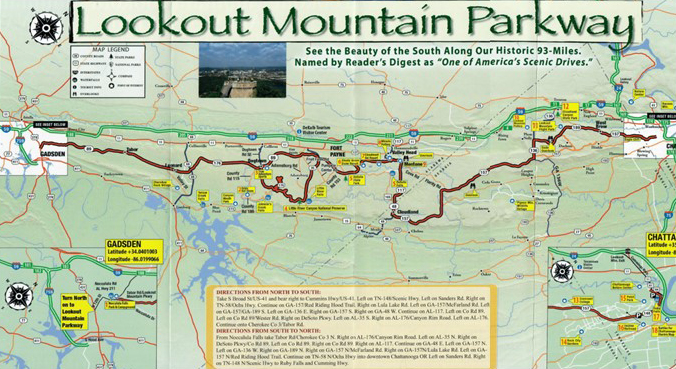
Lookout Mountain Parkway
- Northern Terminus: Chattanooga, TN
- Southern Terminus: Noccalula Falls Park in Gadsden, AL
- Roads: TN-148, GA-189, GA-157, GA-48, AL-117, CR-89, AL-35, AL-176, CR-89
- Distance: 93 miles
- Designation: Alabama State Scenic Byway, HOG 50 Rides 1 Nation
- First Ride: Sep 2023 on 2022 H-D Heritage
- Synopsis: Two-lane roads spanning three states (TN, GA, AL) with mountain vistas, rolling hills, quaint small towns, waterfalls, canyons, state parks, and national preserves with numerous overlooks; sections of straight runs interspersed with steep, sharp twisties
- Personal Highlights: Little River Canyon National Preserve and waterfall (photo), Alabama band memorial in Fort Payne, DeSoto State Park, Chickamauga and Chattanooga National Military Park, and numerous Trail of Tears sites

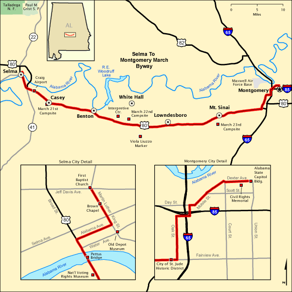
Selma to Montgomery March Byway
- Western Terminus: First Baptist Church at 709 Martin Luther King St, Selma, AL
- Eastern Terminus: Alabama State Capital Building in Montgomery, AL
- Roads: Martin Luther King, Jr. St., Alabama Ave., US-80, W Fred D Gray Ave., S Holt St., Mobile St., Dexter Ave.
- Distance: 54 miles
- Designation: All-American Road
- First Ride: Oct 2022 on 2022 H-D Heritage
- Synopsis: Urban streets and a flat, mostly straight four-lane highway through countryside retraces the steps of the 1965 Selma to Montgomery March, led by Martin Luther King, Jr. Historic buildings, campsite locations, interpretive centers, and museums make education, rather than scenery, the focus of this route.
- Personal Highlights: National Voting Rights Museum and Institute, Edmund Pettis Bridge (photo), Lowndes Interpretive Center, National Memorial for Peace and Justice, Legacy Museum, and Rosa Parks Museum
ALASKA
Haven’t ridden in Alaska. . . YET!
ARIZONA

Historic Route 66- Arizona
- Western Terminus: Ingman, AZ
- Eastern Terminus: Lupton, AZ
- Road: Several old Route 66 sections of pavement and present-day roads make up the multiple alignments of this historic route
- Distance: 305 miles
- Designation: Natl Scenic Byway and All-American Road
- First Ride: Oct 2007 on 2006 H-D Sportster
- Synopsis: Old Rte 66 roads vary from crumbling two-lane pavement to smooth interstate highways that vary depending on which of the multiple alignments you follow (course changed numerous times over the years that it was an active route); each alignment of the route is a part of Americana and road trip culture: neon signs, diners, motels, nostalgic businesses, and “giants.”
- Personal Highlights: Petrified Forest National Park, rusted out Studebaker in Arizona Painted Desert (photo), and Route 66 “trading posts”

ARKANSAS

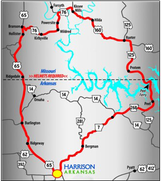
Peel Ferry Route
- Termini: Harrison, AR (with loop through Missouri)
- Roads: US-65, MO-76, US-160, MO-125, AR-268, AR-7
- Distance: 118 miles
- Designation: Local favorite
- First Ride: Sep 2023 on 2022 H-D Heritage
- Synopsis: Two- and four-lane roads through rolling, wooded landscapes, farmland, and downtowns, with lake bridges and a ferry
- Personal Highlights: River Run Park, historic downtown Branson, and traversing Bull Shoals Lake on the Peel Ferry
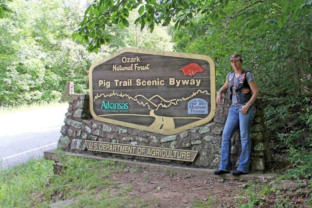
Pig Trail Scenic Byway
- Northern Terminus: Intersection of AR-16 and AR-23 near Brashears, AR
- Southern Terminus: Intersection of AR-23 and I-40 north of Ozark, AR
- Road: AR-23
- Distance: 19 miles
- Designation: AR State Scenic Byway, HOG 50 Rides 1 Nation
- First Ride: June 2015 on 2012 H-D Streetglide
- Synopsis: Two-lane, twisty, mostly tree-canopied road through Ozark National Forest
- Personal Highlights: Gorgeous overlooks and side trip to Eureka Springs

CALIFORNIA

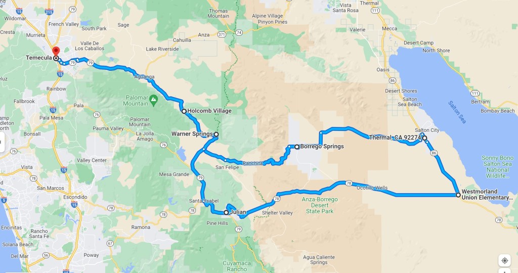
Anza Borrego Desert
- Termini: Temecula, CA (with loop through Anza Borrego Desert)
- Roads: CA-79, S-22, CA-86, CA-78
- Distance: 217 miles
- Designation: Local Favorite
- First Ride: Mar 2008 on 2006 H-D Sportster
- Synopsis: Two-lane roads through rolling ranchland, mountain twisties, and desert terrain.
- Personal Highlights: Julian pies, watching paragliders, and desert octillo blooms.

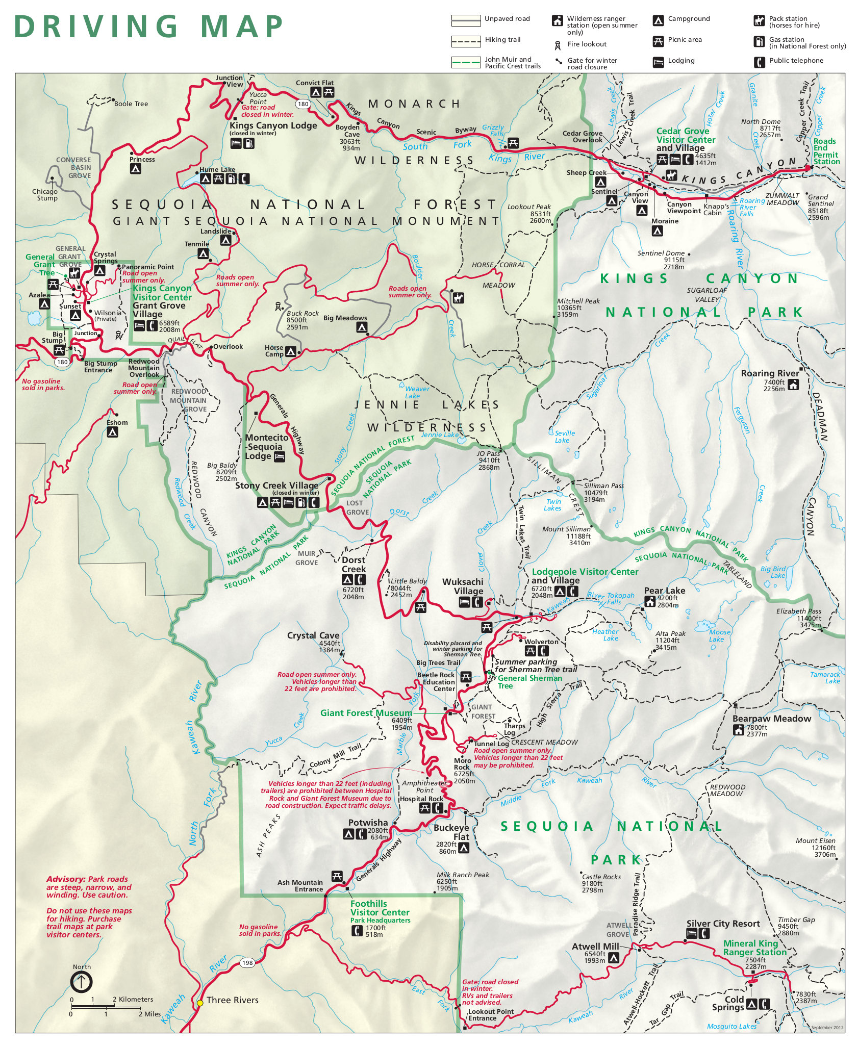
Kings Canyon and Generals Highway
- Northern Terminus: Kanawyers, CA in Kings Canyon National Park
- Southern Terminus: Foothills Visitors Center Sequoia National Park in Three Rivers, CA
- Roads: Kings Canyon Highway (CA-180), Generals Highway (CA-198)
- Distance: 140 miles
- Designation: Butler Maps G1 Series Route, National Park Service Roads (fees involved)
- First Ride: Sep 2022 on 2022 H-D Heritage
- Synopsis: Kings Canyon Highway (CA-180) provides breathtaking vista views of granite walls along the south fork of the Kings River and terminates at a ranger station deep in the valley (so you have to turn around and ride it again!). There are 130 curves and 12 switchbacks in a 16-mile section of Generals Highway (CA-198) that provides commanding views of Giant Sequoia and Redwood Trees. One of my favorite all-time rides!
- Personal Highlights: Elderberry bushes along Kings Canyon Highway, Junction View, Yucca Point, Zumwalt Meadow, Redwood Mtn Overlook, and Crescent Meadow

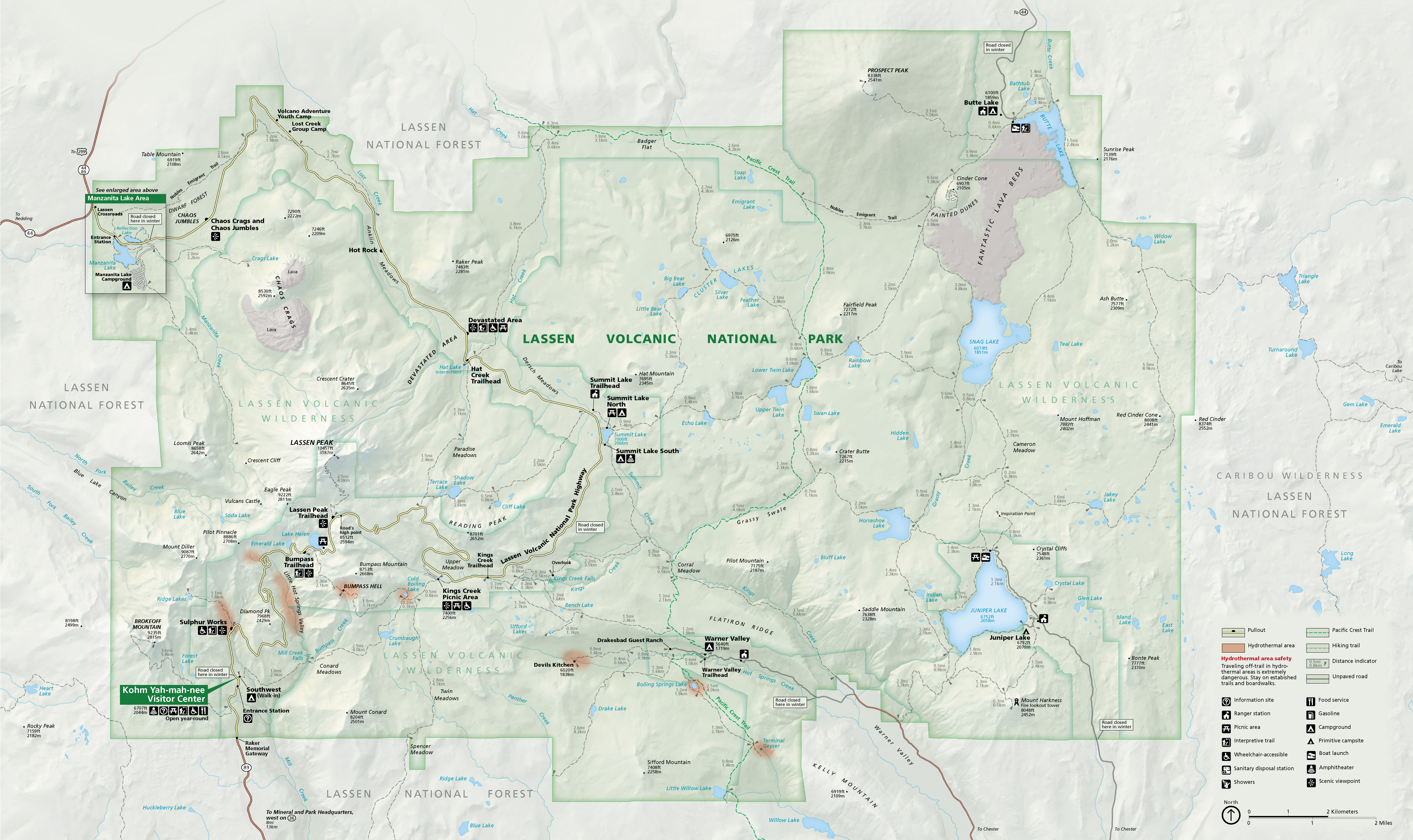
Lassen Volcanic National Park Highway
- Northern Terminus: Manzinita Lake Entry Station [Intersection of CA-89/Lassen Volcanic Park Highway] 40 miles south of Burney, CA
- Southern Terminus: Intersection of CA-89/Lassen Volcanic Park Highway and CA-36
- Road: CA-89/Lassen Volcanic Park Highway
- Distance: 30 miles
- Designation: Butler Maps G1 Series Route and part of Volcanic Legacy Scenic Byway All-American Road, National Park Service Roads (fees involved)
- First Ride: Sep 2022 on 2022 H-D Heritage)
- Synopsis: Road full of twisties and switchbacks with remarkable views of pristine alpine lakes, meadows, hydrothermal areas, boulder fields, lava domes, and mountain peaks. Stunning ride over a volcanic crater!
- Personal Highlights: Emerald Lake, Lake Helen, Bumpass Hell Trail, and Lassen Peak (8,512 ft) (photo)

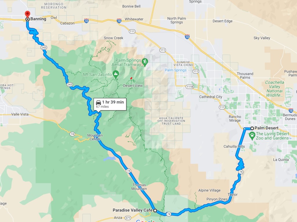
Palms to Pines Scenic Byway
- Western Terminus: Banning, CA
- Eastern Terminus: Palm Desert, CA
- Roads: CA-243, SR-74
- Distance: 67 miles
- Designation: CA State Scenic Byway, HOG 50 Rides 1 Nation
- First Ride: Sep 2022 on 2022 H-D Heritage
- Synopsis: Leisurely, straight stretch of road through desert and forest, sandwiched by two segments of twisties and hairpin turns through Santa Rosa and San Jacinto National Monument in the east, and Mount San Jacinto State Park in the west
- Personal Highlights: Santa Rosa and San Jacinto National Monument Visitor Center, Coachella Valley Vista Point (photo) and Paradise Valley Café.

Sunrise Highway Loop
- Northern Terminus: Julian, CA and Sunrise Highway
- Southern Terminus: Intersection of Sunrise Highway and I-8
- Roads: CA-79, Sunrise Highway, Old Highway 80
- Distance: 76 miles
- Designation: Local favorite
- First Ride: Apr 2008 on 2006 H-D Sportster
- Synopsis: Roads with twisties through Cleveland National Forest amongst unspoiled mountain meadows and sweeping vistas with 5,000 ft of elevation change
- Personal Highlights: Miners Diner in Julian, Lake Cuyamaka (photo), and Mount Laguna Overlook

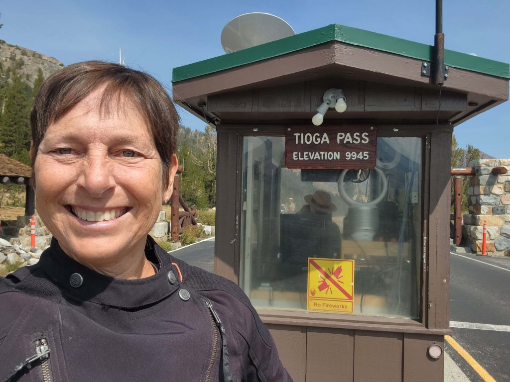
Tioga Road
- Eastern Terminus: Crane Flat in Yosemite Natl Park
- Western Terminus: Tioga Pass in Yosemite Natl Park
- Road: CA-120/Tioga Road
- Distance: 46 miles
- Designation: Butler Maps G1 Series Route, National Park Service Roads (fees involved)
- First Ride: Sep 2022 on 2022 H-D Heritage
- Synopsis: Road with twisties and sweepers that facilitate sightseeing of meadows, lakes, peaks, and the Toulumne River with multiple pull-offs and almost 4,000 feet of elevation change.
- Personal Highlights: Olmstead Point, Tenaya Lake, Toulumne Meadows, Tioga Pass (9,945 ft), Yosemite Valley, El Portal View, and Mariposa Grove

COLORADO
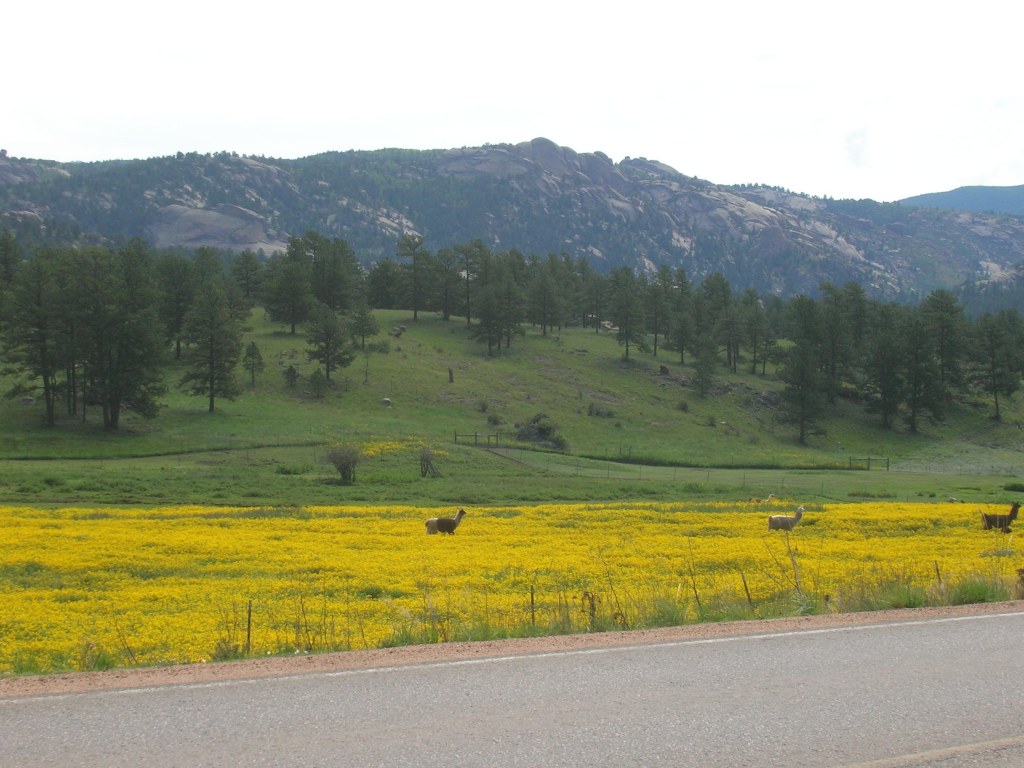
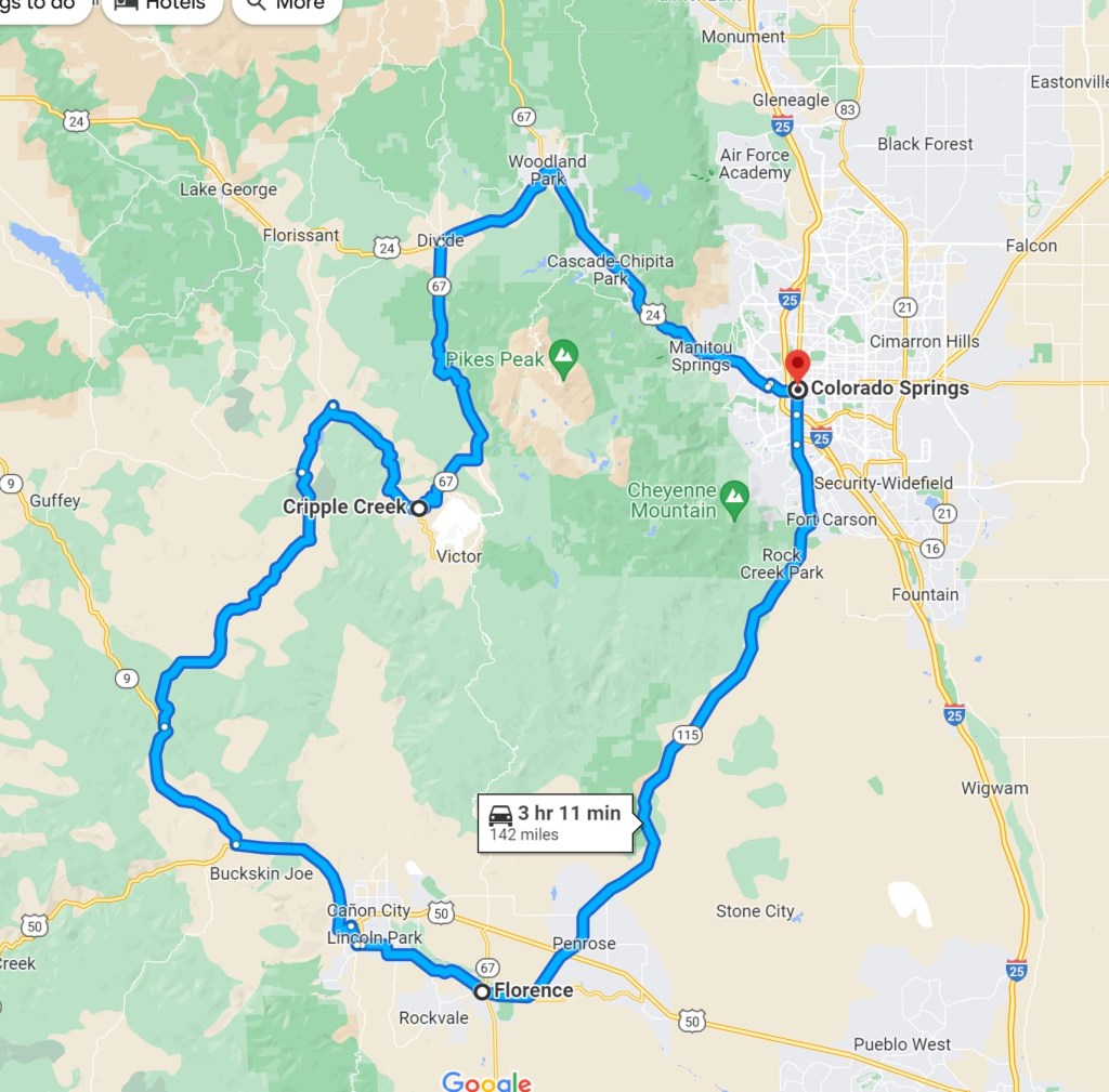
Cripple Creek Loop
- Termini: Colorado Springs, CO (with loop thru Woodland Park, Cripple Creek, Cañon City, and Florence)
- Roads: US-24, CO-67, CO-9, CO-115
- Distance: 142 miles
- Designation: Local favorite with sections part of National Scenic Byway (Gold Belt Tour Scenic and Historic Byway)
- First Ride: Aug 2006 on 2006 H-D Sportster
- Synopsis: Mix of twisty state roads and national highway with approx. 4,000 ft of elevation change through towns and cities around Pikes Peak.
- Personal Highlights: First road trip on 2006 H-D Sportster, biker-friendly old mining town of Cripple Creek, fields of wildflowers and livestock (photo), and side trips to Royal Gorge and Skyline Dr. in Cañon City
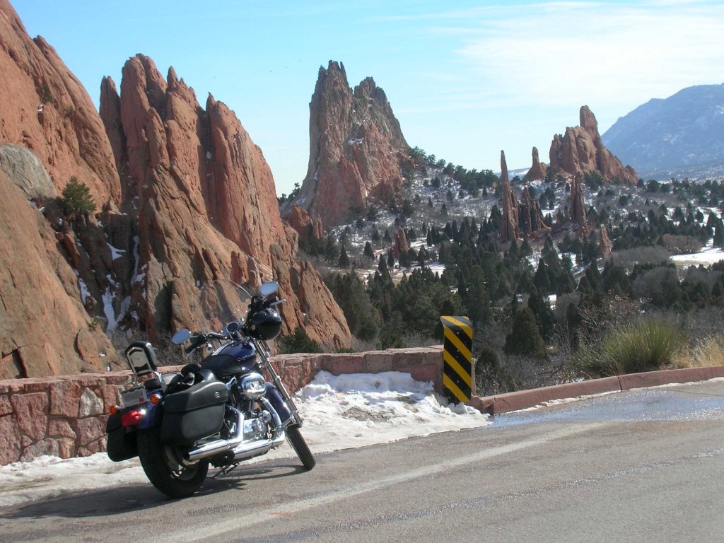
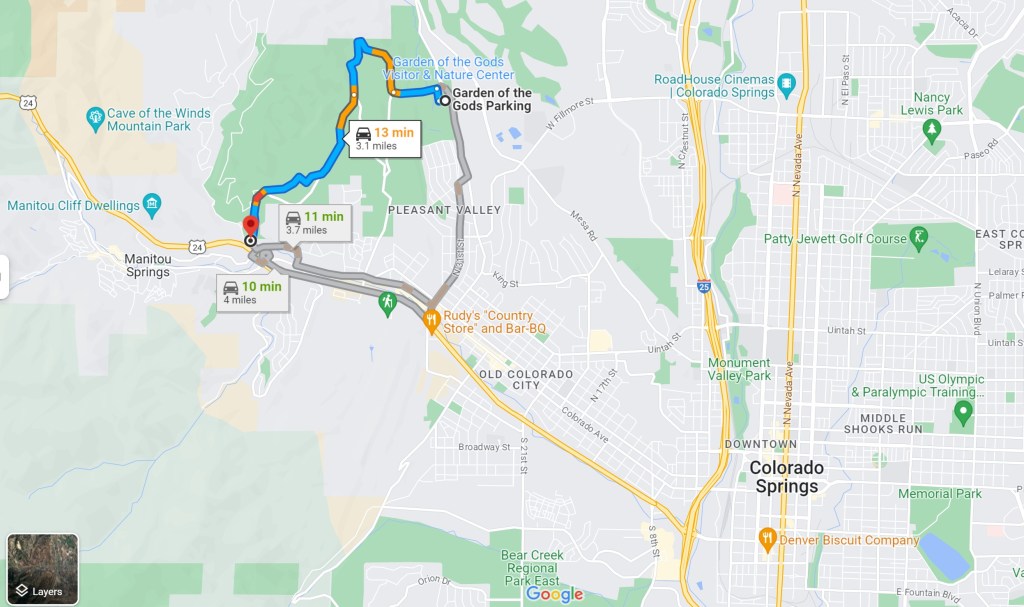
Garden of the Gods
- Western Terminus: Intersection of El Paso Blvd and Garden Dr. near Manitou Springs, CO
- Eastern Terminus: Garden of the Gods Visitor and Nature Center on N 30th St. in East Colorado Springs, CO
- Road: Garden Dr.
- Distance: 13 miles
- Designation: Local Favorite
- First Ride: Feb 2007 on 2006 H-D Sportster
- Synopsis: Twisty road through a Natl Natural Landmark with beautiful views of red rock geologic features
- Personal Highlights: Perkins Central Garden Trail, and watching rock climbers

Million Dollar Highway
- Northern Terminus: Ouray, CO
- Southern Terminus: Silverton, CO
- Road: US-550
- Distance: 25 miles
- Designation: Part of the San Juan Skyway a National All-American Road, HOG 50 Rides 1 Nation
- First Ride: Jul 2008 on rented H-D Heritage
- Synopsis: Twisty narrow-lane road full of hairpin turns, often without guardrails over deep drop-offs, traversing the Uncompahgre Gorge with gorgeous views of San Juan Natl Forest, Animas River, lakes, and abandoned mines. One of my all-time favorite rides!
- Personal Highlights: Main streets of Ouray and Silverton, and three 10K+ mountain passes (Coal Bank Pass at 10,640 ft, Molas Pass at 10,970 ft, and Red Mountain Pass at 11,018 ft)

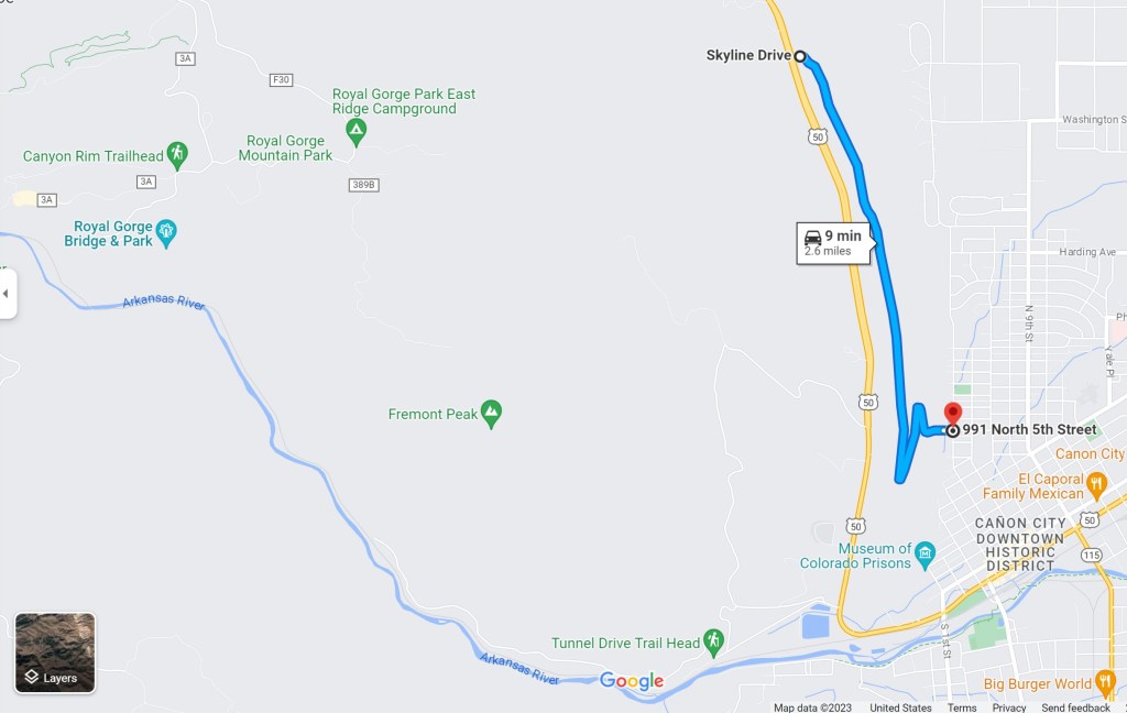
Skyline Drive
- Northern Terminus: Intersection of US-50 and Skyline Dr north of Cañon City, CO
- Southern Terminus: intersection of N. 5th St. and Floral Ave. in Cañon City, CO
- Road: Skyline Dr.
- Distance: 2.5 miles
- Designation: Local favorite
- First Ride: Jul 2008 on 2006 H-D Sportster
- Synopsis: A long, straight, undulating, single-lane ribbon of road atop Razorback Ridge that terminates into a couple of roller-coaster, hairpin turns at Cañon City, CO; this route has no guardrails between the pavement and steep drop-offs
- Personal Highlights: Sweeping views of mountain peaks and plains from single pull-off, and side trip to Royal Gorge
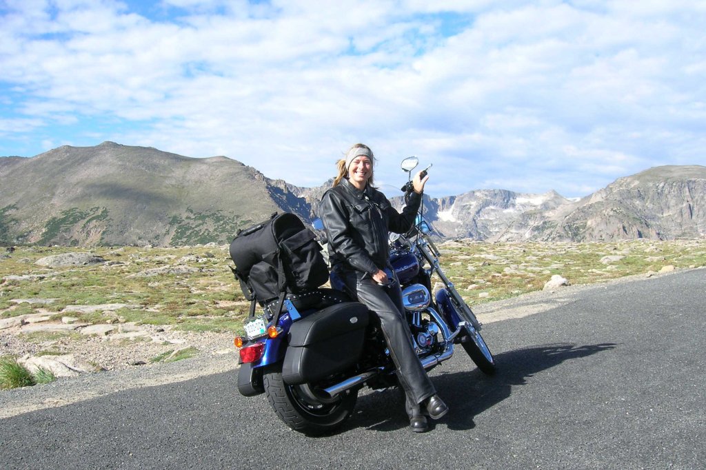
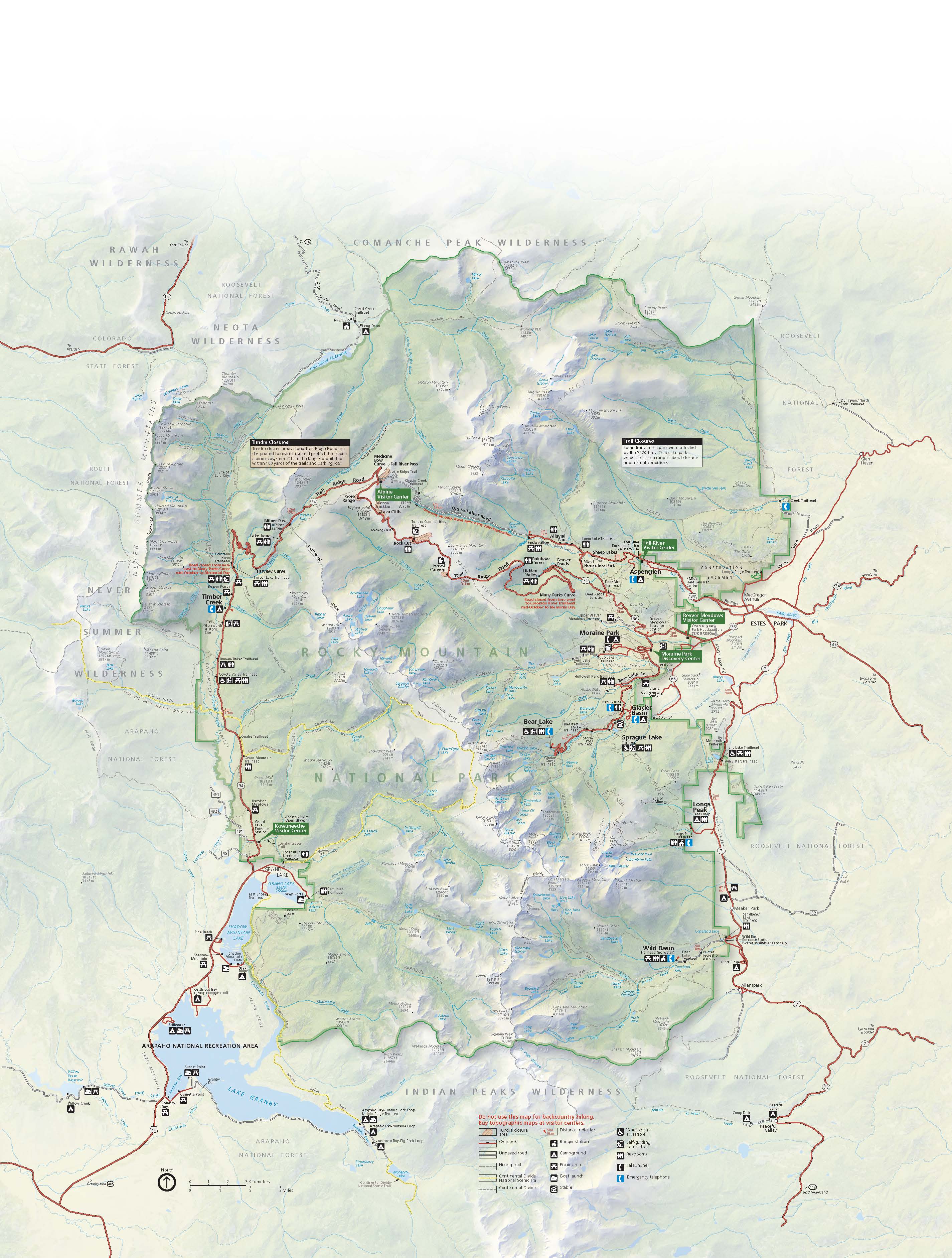
Trail Ridge Road
- Western Terminus: Kawuneeche Rocky Mountain Natl Park Visitor Center at Grand Lake, CO
- Eastern Terminus: Beavers Meadow Rocky Mountain National Park Visitor Center at Estes Park, CO
- Road: US-34/ Trail Ridge Road
- Distance: 48 miles
- Designation: All-American Road, National Park Service Scenic Drive, and Colorado Scenic and Historic Byway, National Park Service Roads (fees involved)
- First Ride: Aug 2007 on 2006 H-D Sportster
- Synopsis: America’s highest paved road (peaks at 12,183 ft) is twisty with areas of intense hairpin turns through Rocky Mountain Natl Park, gorgeous views of multiple 11K ft peaks, lakes, ponds, and valleys.
- Personal Highlights: Iceberg Pass (11,827 ft), alpine tundra ecosystem (photo), Poudre Lake, and Continental Divide at Milner Pass
CONNECTICUT
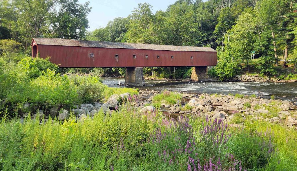
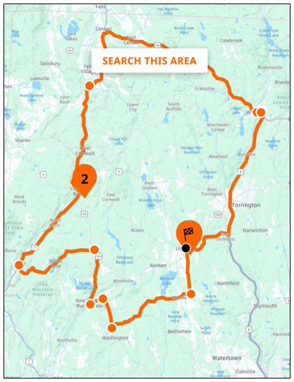
Litchfield Hills Loop
- Loop: Northeast Connecticut
- Roads: CR-118, CR-63, CR-109, CR-57, US-202, CR-45, CR-341, US-7, US-44, CR-8
- Distance: 40 miles
- Designation: HOG 50 Rides 1 Nation
- First Ride: Aug 2026 on 2022 H-D Heritage
- Synopsis: Mix of county roads and highways looping through quintessential New England countryside scenery, complete with colonial homes, historic sites, and state parks
- Personal Highlights: Historic West Cornwall Covered Bridge (photo)
DELAWARE
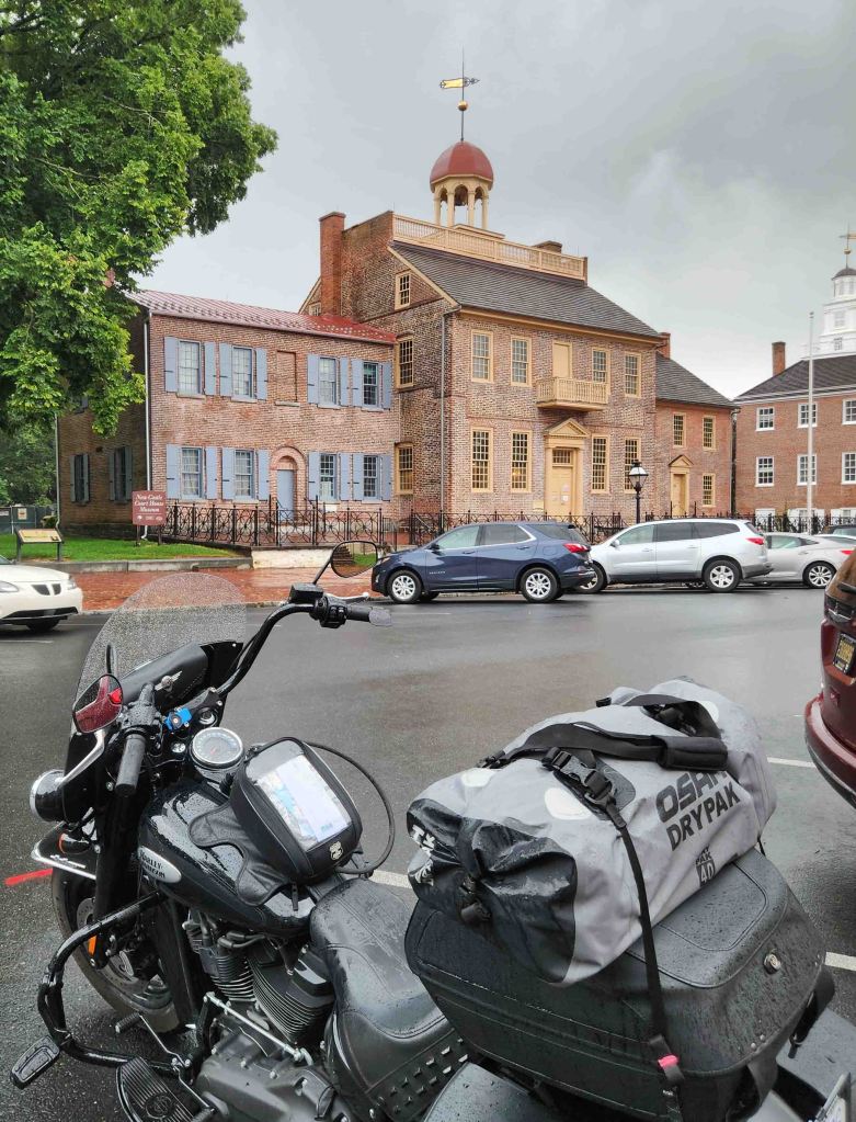
Delaware Bayshore Byway
- Northern Terminus: New Castle, DE
- Southern Terminus: Lewes, DE
- Roads: DE-9, DE-1, and various roads leading to Delaware Bay
- Distance: 157 miles
- Designation: National Scenic Byway, HOG 50 Rides 1 Nation
- First Ride: Jul 2023 on 2022 H-D Heritage
- Synopsis: Two-lane roads running along the Delaware Bay, leading to historic sites, beach towns, and wildlife refuges.
- Personal Highlights: First State Historical Park sites (photo), Dover Air Force Base, and Lewes-Cape May ferry

DISTRICT OF COLUMBIA

Rolling Thunder Route
- Western Terminus: Pentagon Parking Lot in Washington DC
- Eastern Terminus: West Potomac Park in Washington DC
- Roads: Washington Blvd, Arlington Memorial Bridge, Constitution Ave. NW, 3rd St., Independence Ave. SW, Ohio Dr. SW
- Distance: 6 miles
- Designation: Demonstration Run
- First Ride: May 2018 on 2012 H-D Streetglide
- Synopsis: Annual iconic event route on city streets blocked to all non-event traffic; ride stage and wait in Pentagon parking lot can be up to 8 hours, but this run is definitely worth experiencing once in your riding life!
- Personal Highlights: Sitting on the hill by Pentagon parking lot for overview of hundreds of thousands of motorcycles, visiting with friends (and making new ones) during pre-ride wait, and returning salute of Tim Chambers (the Saluting Marine) on the route

FLORIDA

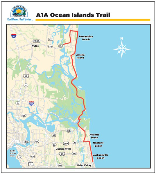
A1A Ocean Islands Trail
- Northern Terminus: Kinglsleys Cut in Fernadina Beach, FL
- Southern Terminus: Intersection of FL-A1A and Jacksonville Dr. in Jacksonville, FL
- Road: FL-A1A
- Distance: 40 miles
- Designation: Florida State Scenic Byway
- First Ride: Mar 2024 on 2022 H-D Heritage
- Synopsis: Two-lane road that connects beaches and barrier islands along Florida’s Atlantic coastline through beach towns of Fernadina, Atlantic, Neptune, Mayport, and Jacksonville.
- Personal Highlights: Timucuan Ecological and Historic Preserve, ferry ride across St. John’s River, NAS Mayport beach sunrise (photo)
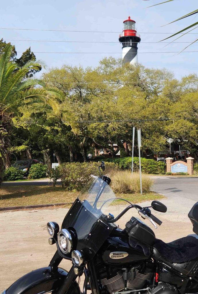
A1A Scenic and Historic Coastal Byway
- Northern Terminus: Intersection of FL-A1A and FL-202 in Ponte Vedra Beach, FL
- Southern Terminus: Bulow Plantation Ruins State Park, south of Flagler Beach
- Road: FL-A1A
- Distance: 72 miles
- Designation: All-American Road
- First Ride: Mar 2024 on 2022 H-D Heritage
- Synopsis: Two-lane road that “connects State Parks, National Monuments, stunning beaches, nature trails, boating, fishing, preserves and estuaries”
- Personal Highlights: Castillo de San Marcos Natl Monument, historic St. Augustine, Ft Matanzas Natl Monument, St. Augustine Lighthouse and Maritime Museum (photo)

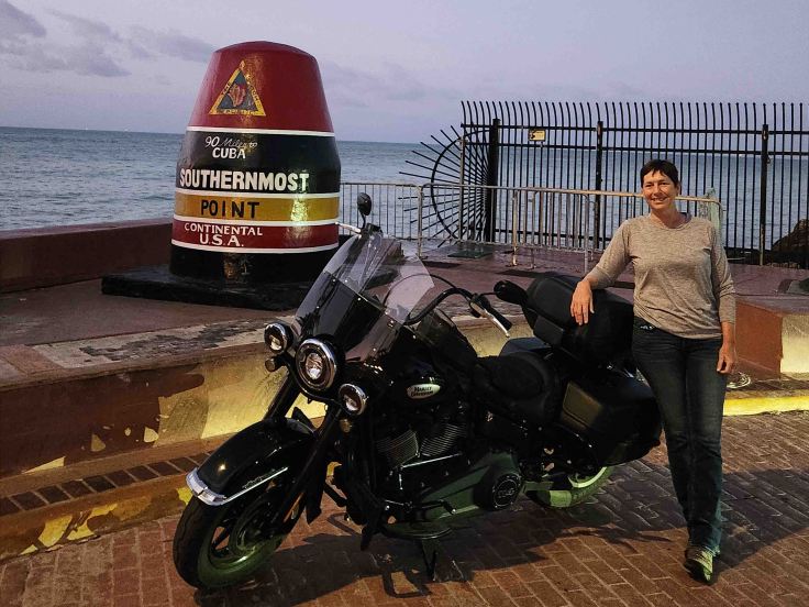
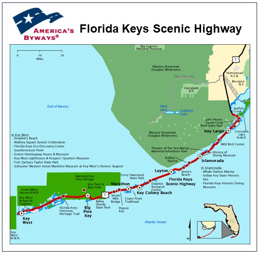
Florida Keys Scenic Highway
- Northern Terminus: US-1 between Long Sound and Manatee Bay near Key Largo, FL
- Southern Terminus: Intersection of Fleming St. and Whitehead St. in Key West, FL
- Road: US-1
- Distance: 107 miles
- Designation: All-American Road
- First Ride: Mar 2024 on 2022 H-D Heritage
- Synopsis: Two-lane iconic last section of US-1; traverses numerous Keys, state parks, marinas, museums, beaches, and endless blue water.
- Personal Highlights: Side trips to Everglades and Biscayne Natl Parks, History of Diving Museum and Lorelei giant mermaid sign in Islamorada, southernmost buoy (photo), and key lime pie

Indian River Lagoon National Scenic Byway
- Northern Terminus: US-1 at Titusville, FL
- Southern Terminus: Intersection of US-1 and FL-510 at Wabasso, FL
- Roads: FL-A1A, US-1, FL-3, FL-405, FL-528, FL-520, FL-404, FL-510
- Distance: 150 miles
- Designation: National Scenic Byway
- First Ride: Mar 2024 on 2022 H-D Heritage
- Synopsis: Two-lane roads that pass through “national seashore, a wildlife refuges, a state park, museums, the Kennedy Space Center, beaches, and waterways”
- Personal Highlights: Side trip to Canaveral Natl Seashore (photo), Cape Canaveral, side trip to US National Navy UDT-SEAL Museum in Fort Pierce, FL

Ormond Scenic Loop and Trail
- Northern Terminus: FL-A1A between Flagler Beach and North Peninsula State Park, FL
- Southern Terminus: Intersection of FL-A1A and FL-40 in Ormond Beach, FL
- Roads: FL-A1A, FL-40, John Anderson Dr., High Bridge Road, Walter Boardman Ln, Old Dixie Hwy, North Beach St.
- Distance: 36 miles
- Designation: National Scenic Byway
- First Ride: Mar 2024 on 2022 H-D Heritage
- Synopsis: Two-lane roads forming a double loop through coastal beach towns, upscale riverside neighborhoods, and oak and palmetto lined Old Florida scenery
- Personal Highlights: Daytona Bike Week H-D Biker Belle Ride (photo), beaches, Old Dixie Hwy scenery


Pensacola Scenic Bluffs Highway
- Northern Terminus: Escambia River Bridge just after intersection of US-90 and US-90A
- Southern Terminus: Bayou Texar Bridge approx. 2 miles east of intersection of I-110 and US-90
- Road: US-90
- Distance: 11 miles
- Designation: Florida State Scenic Highway
- First Ride: Apr 2022 on 2012 H-D Streetglide
- Synopsis: Two-lane highway that parallels the shore of Escambia Bay, traversing bayous, bays, and beaches with “scenic vistas from atop giant bluffs that are the highest points along Florida’s entire coastline.”
- Personal Highlights: Bay Bluffs Park (forgot to take pics!) and side trip to Seville Harbor Marina Fish House (photo)

GEORGIA

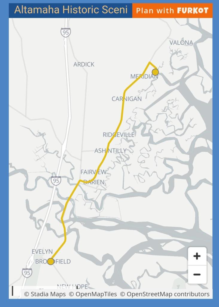
Altahama Historic Scenic Byway
- Northern Terminus: Sapelo Island Visitor Center
- Southern Terminus: Intersection of US-17 and GA-99 at Broadfield, GA
- Roads: GA-99, US-17
- Distance: 17 miles
- Designation: Georgia State Scenic Byway
- First Ride: Mar 2024 on 2022 H-D Heritage
- Synopsis: Two-lane roads, “collage of history; from Guale Indians and 16th and 17th century Spanish missionaries to the pre-colonial occupation of Fort King George; from hardy Scottish Highland soldiers and colonists to the rice and cotton planters who succeeded them”
- Personal Highlights: Butler Plantation ruins (photo), Highlander Scottish history in Darien, side trip to Fort Frederica Natl Monument
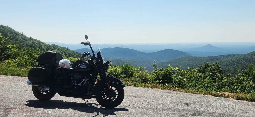
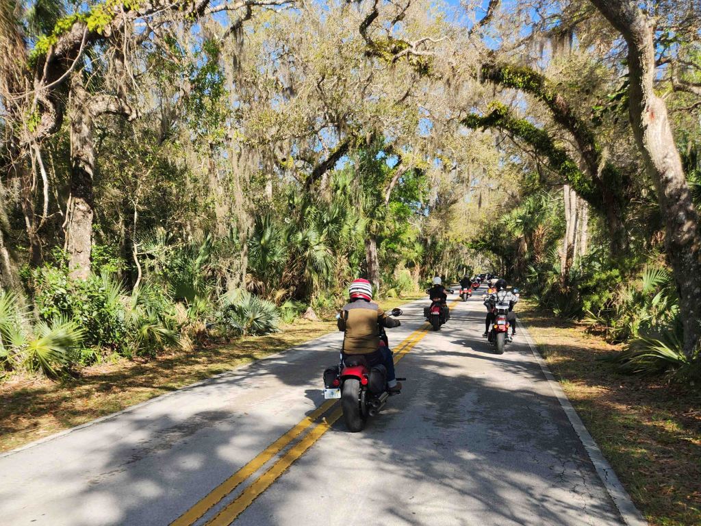
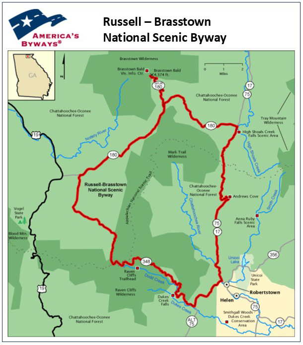
Russell – Brasstown National Scenic Byway
- Northern Terminus: Brasstown Bald Visitor Center in Hiawassee, GA
- Southern Terminus: Intersection of GA-75A and GA-348 approx. 3 miles southwest of Helen, GA
- Roads: GA-75A, GA-348, GA-180, GA-17, GA-75
- Distance: 41 miles
- Designation: National Scenic Byway and Georgia State Scenic Byway
- First Ride: Jun 2025 on 2022 H-D Heritage
- Synopsis: Two-lane state roads through Chattahoochee National Forest full of sweepers and a few twisties, with pull-off overlooks of the valleys and mountain gaps of the southern Appalachians
- Personal Highlights: Scenic overlooks (photo) and side trip to Helen, GA

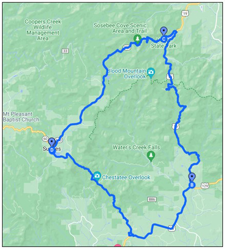
Suches Loop
- Northern Terminus: Intersection of US-19 and GA-180 near Vogel State Park
- Southern Terminus: Intersection of US-19 and GA-60 at Stonepile Gap/Trahlyta’s Grave
- Roads: US-19, GA-60, GA-180
- Distance: 37 miles
- Designation: Local favorite, HOG 50 Rides 1 Nation
- First Ride: Sep 2023 on 2022 H-D Heritage
- Synopsis: Two-lane road of twisties (aka Georgia’s Tail of the Dragon) through Chattahoochee Natl Forest and Blue Ridge Mountains. Very few scenic pull-offs.
- Personal Highlights: Vogel State Park, sharing travel stories with other bikers in parking lot of Two Wheels of Suches campground, and Stonepile Gap/ Trahlyta’s Grave

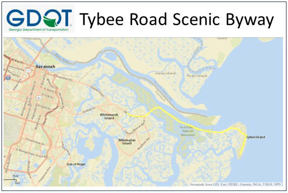
Tybee Road Scenic Road
- Western terminus: US-80 at western bank of Turner Creek on Talahi Island
- Eastern terminus: Intersection of US-80 and Tybrisa St. on Tybee Island
- Road: US-80
- Distance: 11 miles
- Designation: South Carolina State Scenic Highway
- First Ride: Mar 2024 on 2022 H-D Heritage
- Synopsis: Straight, flat two-lane road that runs along Savannah River and the Atlantic Ocean on Tybee Island
- Personal Highlights: Fort Polaski Natl Monument, serene beach settings (photo)
HAWAII
Haven’t ridden in Hawaii. . . YET!
IDAHO

Northwest Passage Scenic Byway
- Western Terminus: Lewiston, ID
- Eastern Terminus: Lolo Pass Visitors Center
- Road: US-12
- Distance: 202 miles
- Designation: All-American Road, HOG 50 Rides 1 Nation
- First Ride: Aug 2022 on 2022 H-D Heritage
- Synopsis: Two-lane road full of alternating sweepers running parallel to the Lochsa Wild and Scenic and the Middle Fork Clearwater Rivers, and stunning views of the Clearwater Natl Forest and Bitterroot Mountains. One of my all-time favorite rides!
- Personal Highlights: First road trip on 2022 H-D Heritage, numerous Lewis & Clark Natl Historic Trail and Nez Perce Natl Historical Park sites, and Lolo Pass (5,233 ft).

ILLINOIS
Ohio River Scenic Byway- Illinois
- Western Terminus: Cairo, IL
- Eastern Terminus: Border of Illinois and Indiana near New Haven, IL
- Road: IL-37, IL-46, IL-1, Shawneetown New Haven Rd, IL-141
- Distance: 160 miles
- Designation: Natl Scenic Byway and HOG 50 Rides 1 Nation
- First Ride: Jun 2025 on 2022 H-D Heritage
- Synopsis: Mix of state two-lane roads meandering along the Ohio River, rich with history of the Ohio River from times of Native Americans to settlers, runs through small towns and state parks
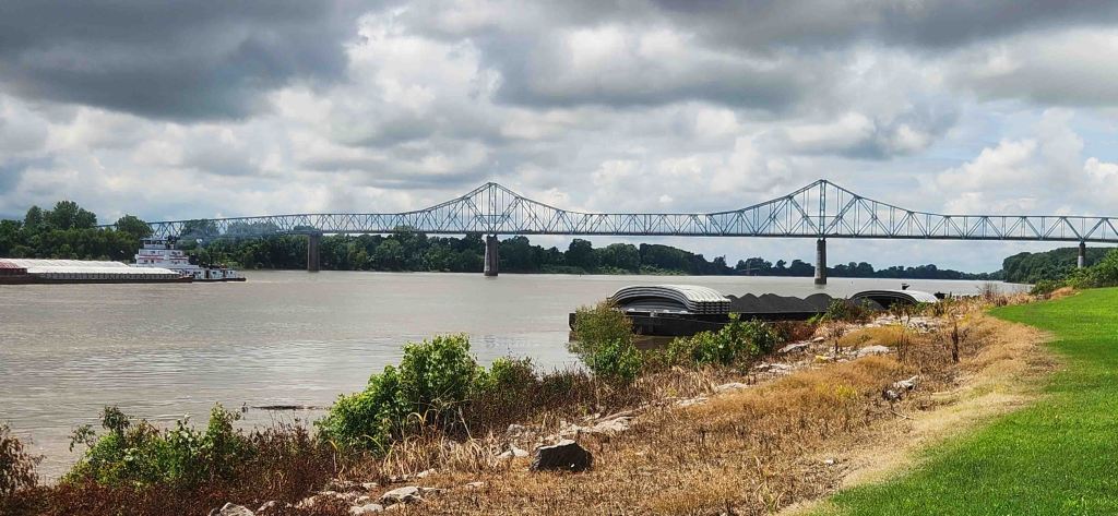
- Personal Highlights: Convergence of the Ohio and Mississippi Rivers at Fort Defiance State Park (photo) and superman town of Metropolis

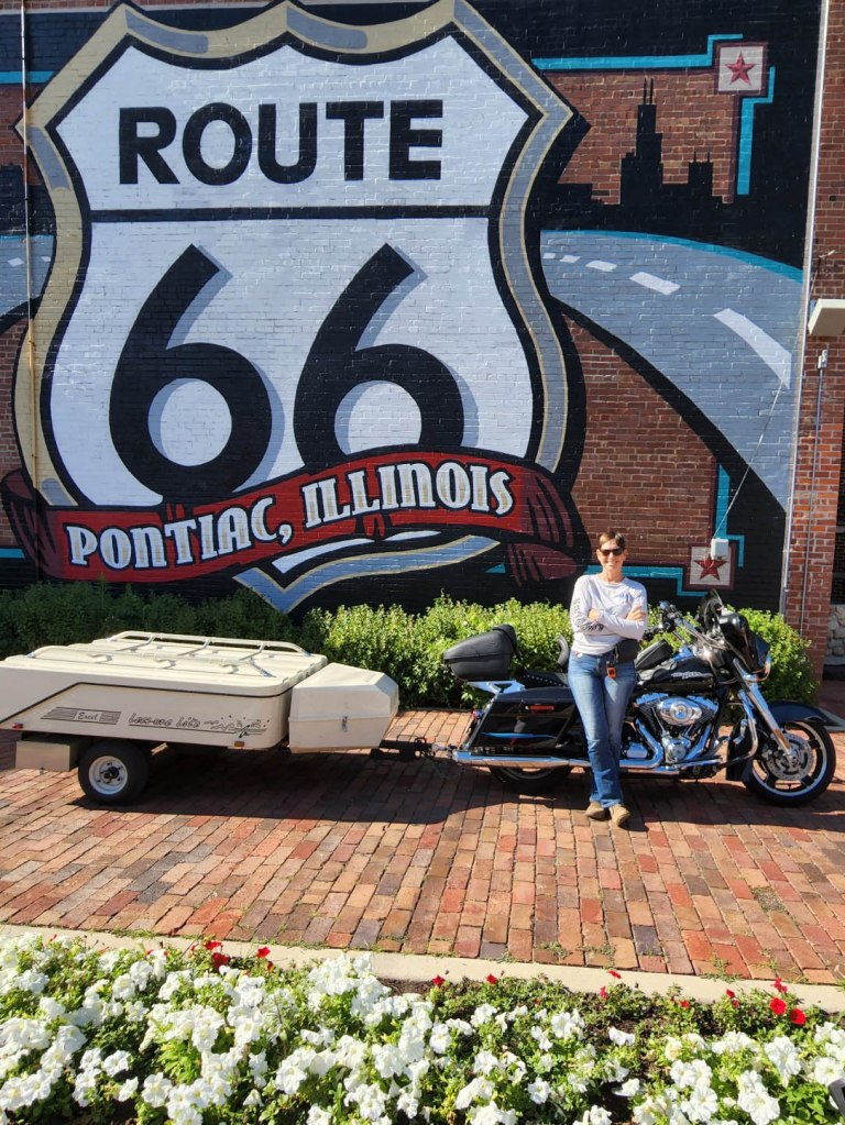
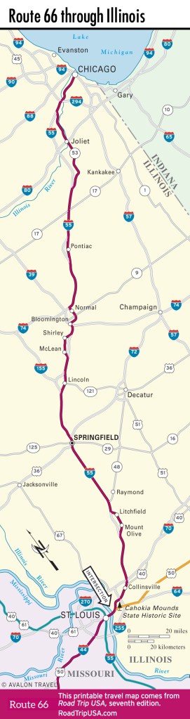
Historic Route 66 – Illinois
- Northern Terminus: Chicago, IL
- Southern Terminus: Illinois-Missouri State Line near St. Louis, MO
- Road: Several Old Route 66 sections of pavement and present-day roads make up the multiple alignments of this historic route. *NOTE, there are two separate “start” and “end” signs for Historic Route 66 in Chicago, IL: Route 66 “START” sign at intersection of E. Adam St. and Michigan Ave., “END” sign at intersection of E. Jackson Dr. and Michigan, Ave.
- Distance: 301 miles
- Designation: Natl Scenic Byway and All-American Road
- First Ride: Jul 2022 on 2012 H-D Streetglide
- Synopsis: Old Route 66 roads vary from crumbling two-lane pavement to smooth interstate highways that vary depending on which of the multiple alignments you follow (course changed numerous times over the years that it was an active route); each alignment of the route is a part of Americana and road trip culture: neon signs, diners, motels, nostalgic gas stations, and “giants.”
- Personal Highlights: Numerous roadside “giants,” historic brick road through farmland, Standard Oil Station, Pontiac Route 66 museum, and super friendly volunteers at museums and sites along the way
INDIANA
I’ve ridden through Indiana, in transit to another state, but haven’t ridden any noteworthy routes yet.
IOWA
Haven’t ridden in Iowa . . . YET!
KANSAS
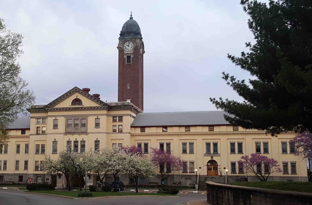
Frontier Military Scenic Byway
- Northern Terminus: Fort Leavenworth, KS
- Southern Terminus: Baxter Springs, KS
- Roads: K-5, I-435, US-69, US-69A
- Distance: 167 miles
- Designation: Kansas State Scenic Byway
- First Ride: Jun 2016 on 2012 H-D Streetglide
- Synopsis: Mix of state and federal highways that follow a path originally built to move soldiers and supplies during the westward migration, with historic military forts, museums, and scenic vistas.
- Personal Highlights: Buffalo Soldier Monument, Army Frontier Museum, Natl Cemetery, and Grant Hall Clock Tower (photo) on Fort Leavenworth, and side trip to Natl World War I Museum in Kansas City
KENTUCKY
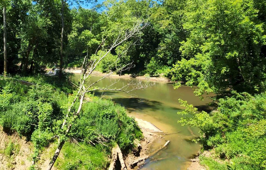
Duncan Hines Scenic Byway
- Termini: Bowling Green, KY (loop through Mammoth Cave National Park and surrounding area)
- Roads: US-31W, KY-101, KY-259, KY-70, KY-187, KY-238, KY-259, KY-728, KY-1827, KY-1352, KY-2325, KY-259
- Distance: 82 miles
- Designation: Kentucky State Scenic Byway
- First Ride: Jun 2022 on 2012 H-D Streetglide
- Synopsis: Numerous state and federal roads that pass through small towns with historic buildings, the Green River ferry crossing, and Mammoth Caves Natl Park, and Duncan Hines’ former house and office
- Personal Highlights: Camping at Mammoth Cave Campground, hiking White Cave, Echo River Springs, and Heritage Trails in Mammoth Cave Natl Park, and Green River (photo)

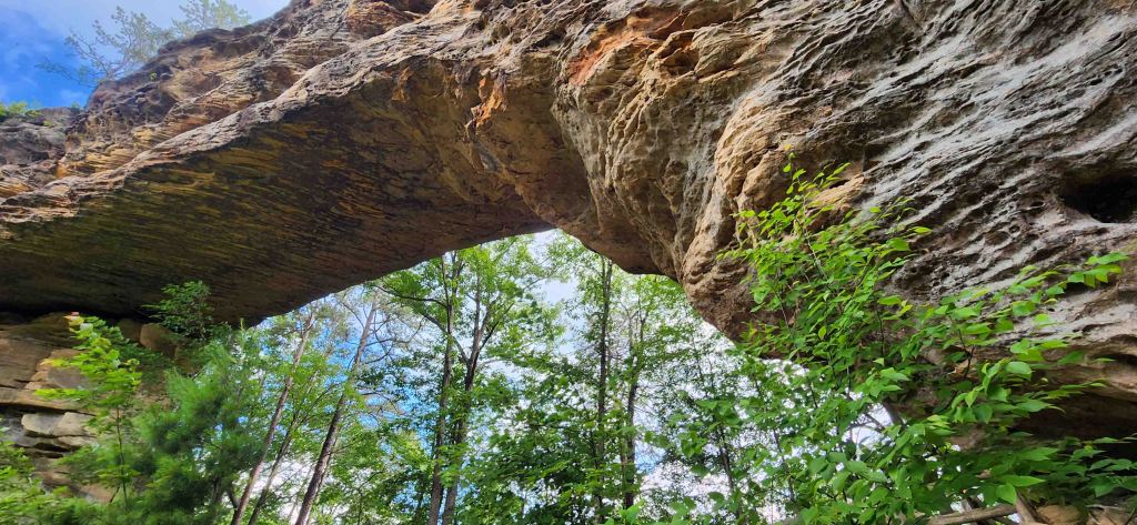
Red River Gorge Scenic Byway
- Western Terminus: Stanton, KY
- Roads: KY-11, KY-77, KY-715, KY-402
- Distance: 61 miles
- Designation: National Scenic Byway and HOG 50 Rides 1 Nation
- First Ride: Jun 2025 on 2022 H-D Heritage
- Synopsis: Single and two-lane roads twisting through Daniel Boone National Forest and Red River Gorge
- Personal Highlights: Single lane tunnels, springtime greenery along ravines and cliffs, stone arches at Natural Arches State Park (photo)

LOUISIANA

Cane River National Heritage Trail Scenic Byway
- Northern Terminus: Grand Ecore Visitor Center at intersection of the Red River and LA-6 north of Natchitoches, LA
- Southern Terminus: Cloutierville, LA
- Roads: LA-6, LA-494, LA-119, LA-1
- Distance: 71 miles
- Designation: Louisiana State Scenic Byway
- First Ride: Sep 2023 on 2022 H-D Heritage
- Synopsis: Two-lane state roads that follow the Cane River through rich farmland and small towns, with numerous plantation houses, historic military forts and churches, and the city of Natchitoches
- Personal Highlights: Ecore Visitor Center, Natchitoches River Walk (photo), Fort St. Jean Baptiste, Oakland Plantation, and side trips to Los Adaes State Historic Site, and Fort Jessup

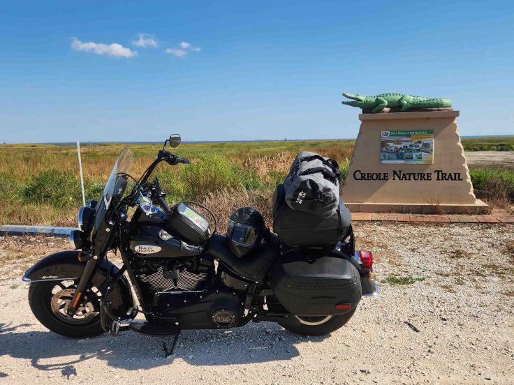
Creole Nature Trail Scenic Byway
- Western Terminus: Texas-Louisiana Border at Sabine Pass
- Eastern Terminus: Rockefeller Wildlife Refuge
- Roads: LA-82, LA-27, LA-384, LA-385, LA-397
- Distance: 207 miles
- Designation: All-American Road, HOG 50 Rides 1 Nation
- First Ride: Sep 2023 on 2022 H-D Heritage
- Synopsis: Flat, straight, two-lane state roads that parallel the Gulf of Mexico and pass through marsh and prairies, providing abundant views of wildlife, flora and fauna that thrive in the continuum of salt to brackish to fresh water deep in Louisiana’s multiple wildlife refuges.
- Personal Highlights: Rockefeller Wildlife Refuge, Cameron-Holly Beach ferry, Blue Crab Recreation Area (photo), and Creole Nature Trail Adventure Visitor Center

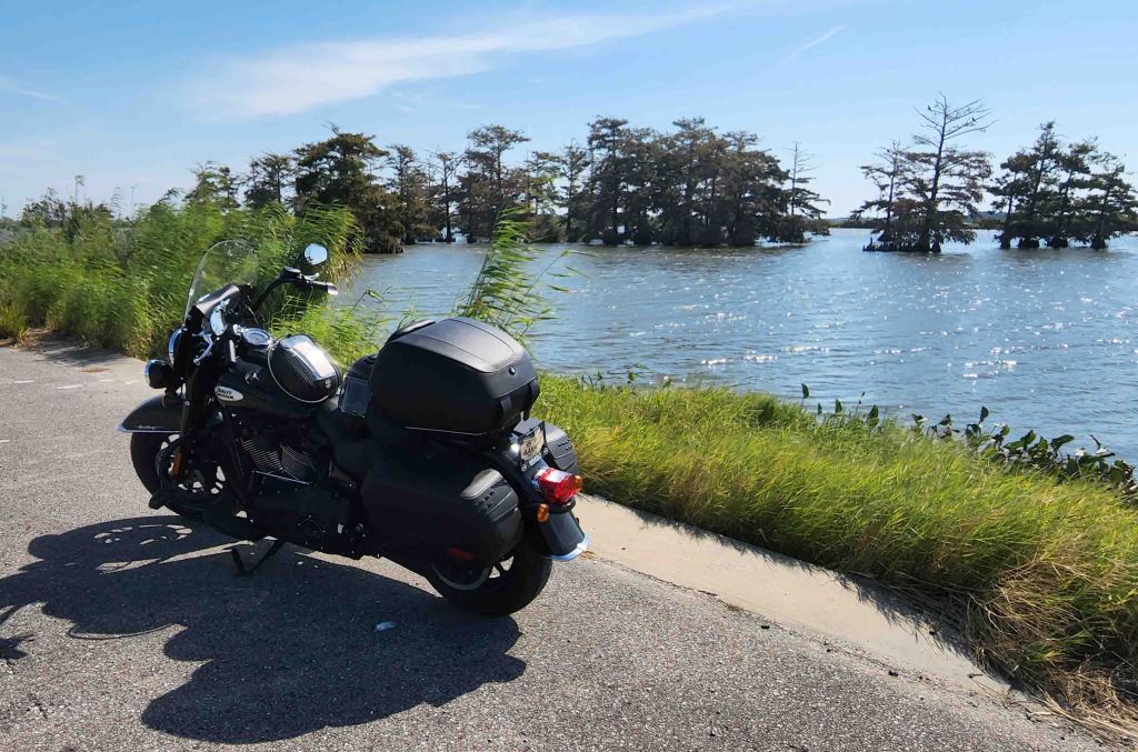
River Road – Louisiana
- Northern Terminus: US-61 about 15 miles north of St. Francisville, LA
- Southern Terminus: End of paved Tide Water Road about 4.5 miles south of Venice, LA
- Road: US-61, LA-18, LA-23
- Distance: 773 miles
- Designation: Natl Scenic Byway and All-American Road
- First Ride: Oct 2022 on 2022 H-D Heritage
- Synopsis: Flat, mostly straight roads paralleling the Mississippi River that include multiple plantation homes, Underground Railroad sites, museums, Natl Park Service sites as well as small towns and big cities (Baton Rouge and New Orleans) full of food, culture, and history.
- Personal Highlights: Atchafalaya Water Heritage Trail, “Easy Rider” filming location in Morganza, The Whitney Plantation, Hale Boggs Memorial Bridge, Huey P. Long Bridge, Fort Jackson, marsh and swamp scenes (photo), the “southernmost point in LA” sign, and side trips to Poverty Point Natl Historic Site and Natchez, MS
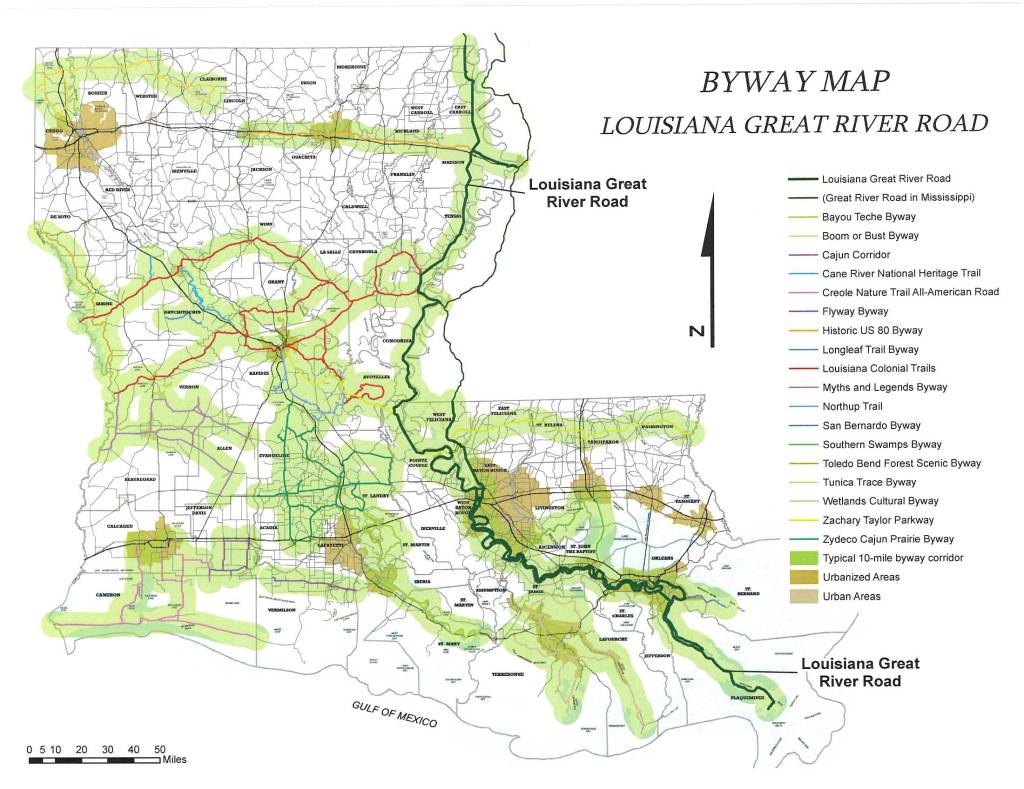

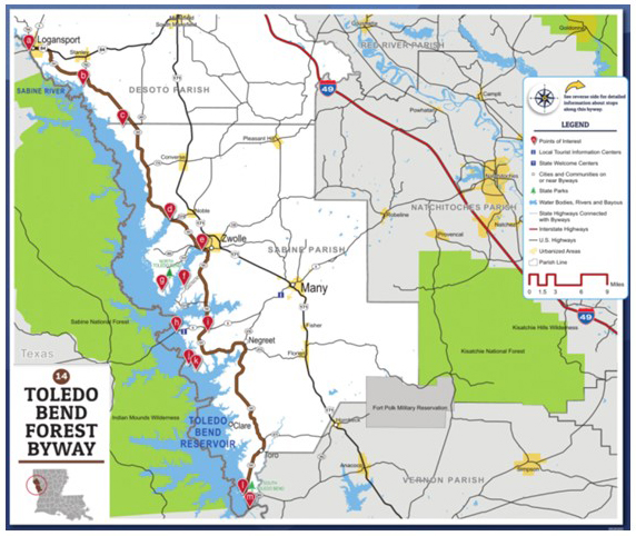
Toledo Bend Forest Scenic Byway
- Northern Terminus: Texas-Louisiana state line at Logansport, LA
- Southern Terminus: Texas-Louisiana state line at Toledo, LA
- Roads: US-84, LA-191, LA-111
- Distance: 78 miles
- Designation: Louisiana State Scenic Byway
- First Ride: Sep 2023 on 2022 H-D Heritage
- Synopsis: Mostly two-lane highways paralleling the largest manmade lake in the south, through a state park, wildlife management areas, historic forts, and scenic overlooks
- Personal Highlights: Fort Jessup State Historic Site, El Camino Real de los Tejas National Historic Trail, and San Patricio Overlook Point (photo)
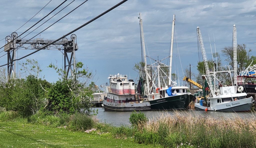
Wetlands Cultural Byways
- Termini: Houma, LA (loop through Terrebonne and Lafourche parishes)
- Roads: LA-182, LA-57, LA-56, LA-24, LA-1, LA-308, LA-307
- Distance: 282 miles
- Designation: Louisiana Byway
- First Ride: Apr 2022 on 2012 H-D Streetglide
- Synopsis: Two-lane, flat roads, running mostly alongside bayous, providing an authentic glimpse into Cajun food, language, and culture alongside the natural beauty of the coastal wetlands
- Personal Highlights: Visiting family in Terrebonne and Lafourche Parishes, Bayou Terrebonne Waterlife Museum, shrimp boats parked alongside homes on Little Caillou (photo), Coco Marina Restaurant, Louisiana Universities Marine Consortium, Jean Lafitte Wetlands Acadian Cultural Center, Regional Military Museum, and Natl Wildlife Refuge Nature Trail
MAINE

Acadia All-American Road
- Northern Terminus: Intersection of US-8 and ME-3 approx. 1.5 miles south of Ellsworth
- Southern Terminus: Acadia National Park Hulls Cove Visitors Center (with loop through the park)
- Roads: ME-3 and Park Loop Road
- Distance: 40 miles
- Designation: All-American Road, HOG 50 Rides 1 Nation, National Park Service Roads (fees involved)
- First Ride: Jun 2022 on 2012 H-D Streetglide
- Synopsis: Gorgeous views from “craggy shorelines and granite-capped mountains to crystal lakes and spruce–fir forests”
- Personal Highlights: Crossing Bar Island Natural Bridge at low tide, Thunder Hole area (photo), camping in Seawall Campground, Otter Cliff Overlook, Bass Harbor Head Light Station, Jordan Lake and side trips to Cadillac Mountain and lunch at Thurston’s Lobster Pound
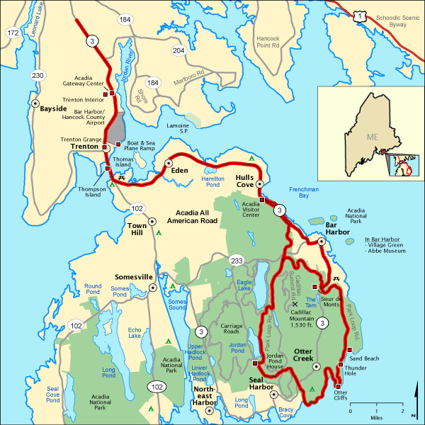

Cadillac Mountain
- Termini: Intersection of Park Loop Road and Cadillac Summit Road in Acadia Natl Park (out and back to summit)
- Road: Cadillac Summit Road
- Distance: 7 miles (total out and back)
- Designation: National Park Service Roads (fees involved)
- First Ride: Jun 2022 (2012 H-D Streetglide)
- Synopsis: Two-lane road with twisties and hairpin turns leading up to Cadillac Mountain with pull-offs for spectacular views of Eagle Lake and Bar Harbor
- Personal Highlights: Cadillac Mountain (1,530 ft), Eagle Lake overview (photo)

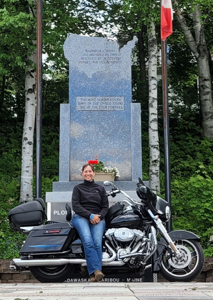
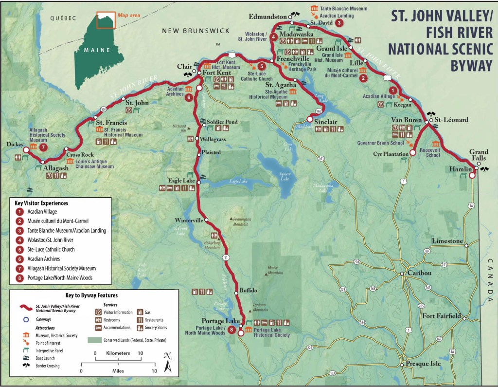
St. John Valley Cultural Byway/Fish River Scenic Byway
- Western Terminus: Dickey, ME
- Eastern Terminus: Grand Falls, ME
- Roads: ME-161, ME-162, ME-11, US-1, US-1A,
- Distance: 129 miles
- Designation: National Scenic Byway
- First Ride: June 2022 (2012 H-D Streetglide)
- Synopsis: Mostly two-lane roads along the northern border of Maine and through the St. John Valley with sites rich in Maine’s Acadian heritage and culture
- Personal Highlights: Acadian Landing and Cross, Madawaska Four Corners Park (photo), International Bridge, Inn of Acadia, ploye for breakfast and poutine for dinner, and America’s First Mile- US Route 1 Marker
MARYLAND

Chesapeake Country Scenic Byway
- Northern Terminus: Chesapeake City, MD
- Southern Terminus: Stevensville, MD
- Roads: MD-213, MD-20, MD-445, MD-18,
- Distance: 115 miles
- Designation: All-American Road
- First Ride: Jul 2023 on 2022 H-D Heritage
- Synopsis: Mostly two-lane highways following the Chesapeake Bay eastern shore that passes through landscapes that has supported watermen, shipbuilders, and farmers since colonial times.
- Personal Highlights: Waterman’s Museum at Rock Hall (photo), Eastern Neck Natl Wildlife Refuge, and side trip to Annapolis and the Naval Academy


Harriet Tubman Underground Railroad Byway
- Northern Terminus: Goldsboro, MD
- Southern Terminus: Bucktown, MD
- Roads: MD-313, MD-480, MD-404, MD-16, US-50, MD-335, and numerous small streets
- Distance: 125 miles
- Designation: All-American Road
- First Ride: Jul 2023 on 2022 H-D Heritage
- Synopsis: Mostly two-lane roads piecing together significant locations in Harriet Tubman’s life, passing through pristine waterways and farmland.
- Personal Highlights: Harriet Tubman Underground Railroad Visitors Center, Blackwater Wildlife Refuge, Brodess Farm, Bucktown Village Store (photo), and Harriet Tubman Memorial Garden

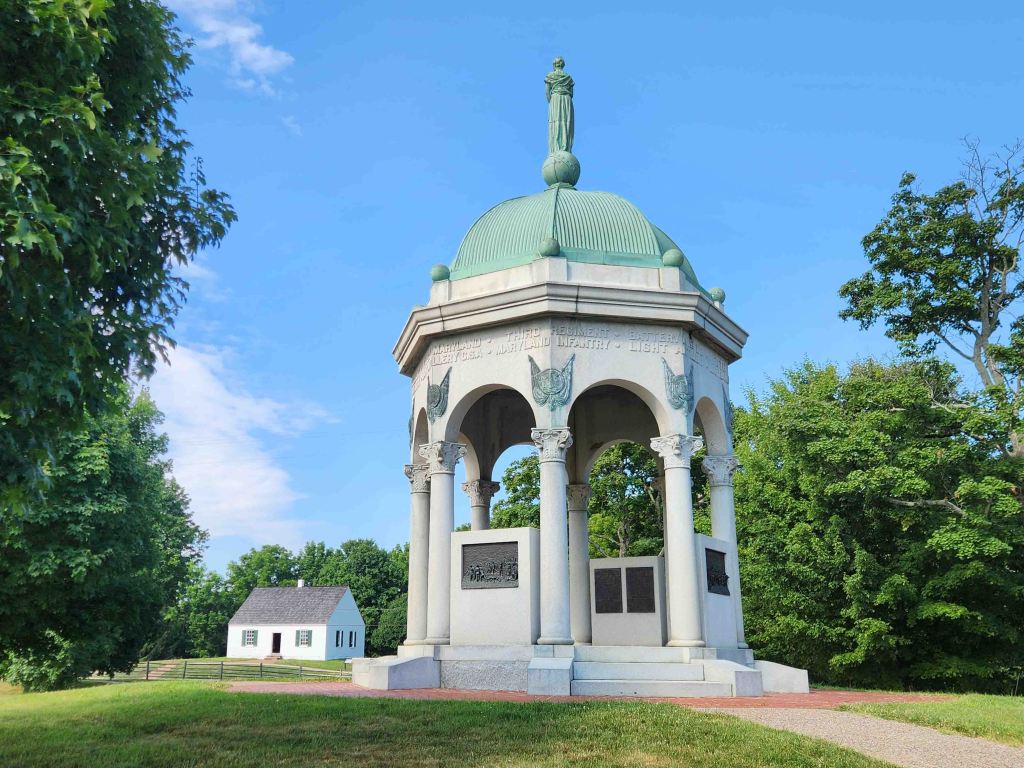
Journey Through Hallowed Ground Scenic Byway
- Northern Terminus: Gettysburg National Military Park, PA
- Southern Terminus: Monticello, VA
- Roads: US-15, US-15 BUS, VA-20, VA-22, VA-53, VA-231
- Distance: 180 miles
- Designation: National Scenic Byway, HOG 50 Rides 1 Nation
- First Ride: Jun 2014 on 2012 H-D Streetglide
- Synopsis: State and federal roads following an active transportation route during the Revolutionary War and Civil War, including historic Underground Railroad sites and battlefields that span three states (PA, MD, VA)
- Personal Highlights: Gettysburg National Military Park, Catoctin Mountain Park, Cunningham Falls State Park, Monocacy and Antietam National Battlefields (photo), The Inn at Antietam, Harpers Ferry, and Appomattox Court House Natl Historical Park

MASSACHUSETTS

Mohawk Trail Scenic Byway
- Western Terminus: Williamstown, MA
- Eastern Terminus: Greenfield, MA
- Road: US-2
- Distance: 69 miles
- Designation: National Scenic Byway
- First Ride: Jun 2022 on 2012 H-D Streetglide
- Synopsis: Two-lane road that follows the traditional route of Native Americans between the Hudson River and Connecticut River Valleys through state parks and forests.
- Personal Highlights: Connecticut River, Shelburne Falls and French King Bridge (photo)

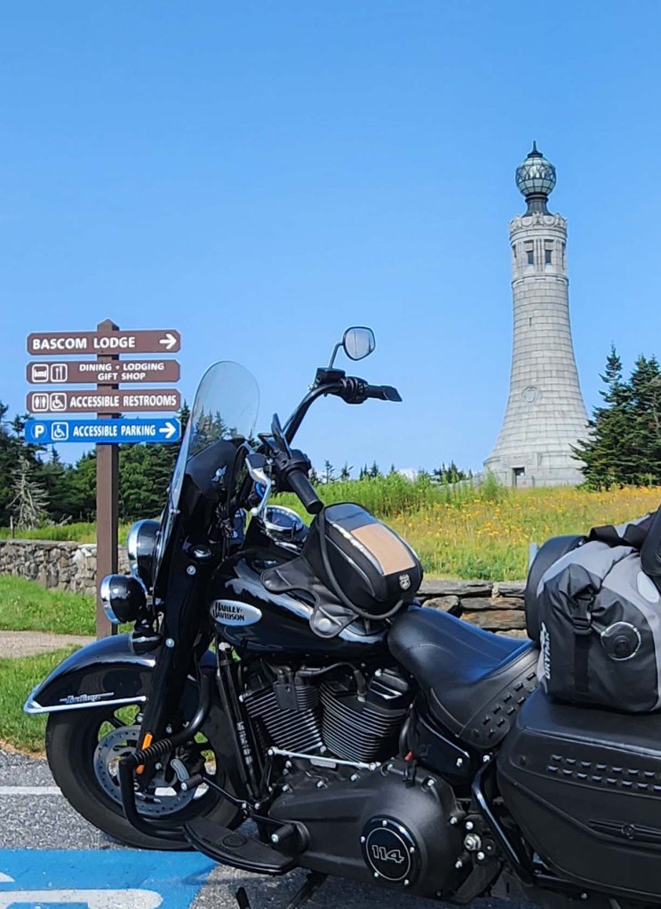
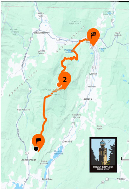
Mount Greylock Scenic Byway
- Northern Terminus: Western Heritage Gateway State Park, MA
- Southern Terminus: Mount Greylock Visitor Center, MA
- Road: Rockwell Rd, Summit Rd, Greylock Mountain Rd, Notch Rd, West Main St/ Mohawk Trail, State Street
- Distance: 19 miles
- Designation: Massachussetts State Byway, HOG 50 Rides 1 Nation
- First Ride: Aug 2025 on 2022 H-D Heritage
- Synopsis: Narrow, twisty two-lane road through Mount Greylock State Reservation’s hardwoods and evergreen forests, and Mount Greylock Summit (3,491 ft)- highest elevation in state
- Personal Highlights: War Memorial Tower (photo), walking part of the Appalachian Trail, lunch at CCC-built Boscom Lodge, and stunning panoramic views of surrounding New York’s Adirondacks and Catskills Mountains, Vermont’s Green Mountains, and the Birkshires.
MICHIGAN
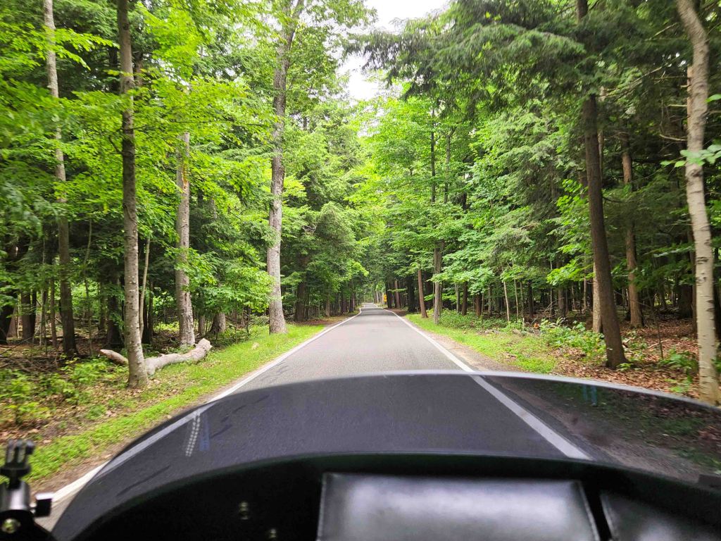
Tunnel of Trees
- Northern Terminus: Cross Village, MI
- Southern Terminus: Harbor Springs, MI
- Road: M-119
- Distance: 20 miles
- Designation: Michigan State Scenic Byway, HOG 50 Rides 1 Nation
- First Ride: Jul 2022 on 2012 H-D Streetglide
- Synopsis: Single lane road through a mixed forest, dominated by mature broad leaf and pine trees, with occasional breathtaking glimpses of Lake Michigan.
- Personal Highlights: Good Hart General Store and white fish meal at Leggs Inn

M-22 Scenic Byway
- Northern Terminus: Traverse City, MI
- Southern Terminus: Intersection of US-31 and M-22 approx. 7 miles south of Onekama, MI
- Road: M-22
- Distance: 116 miles
- First Ride: Jul 2022 on 2012 H-D Streetglide
- Designation: Michigan State Scenic Byway
- Synopsis: Two-lane highway that hugs the shore of Lake Michigan with numerous overviews, lighthouses, cherry orchards, Sleeping Bear Dunes Natl Lakeshore and is part of the Lake Michigan Circle Tour
- Personal: Highlights: Sleeping Bear Dunes Natl Lakeshore (photo), camping in Platte River Campground, white fish meal at Good Harbor Grill, Grand Traverse Lighthouse, Leelanau State Park, cherry orchids, crossing the 45th parallel, and a Cosmo Cone from the Dairy Lodge

MINNESOTA
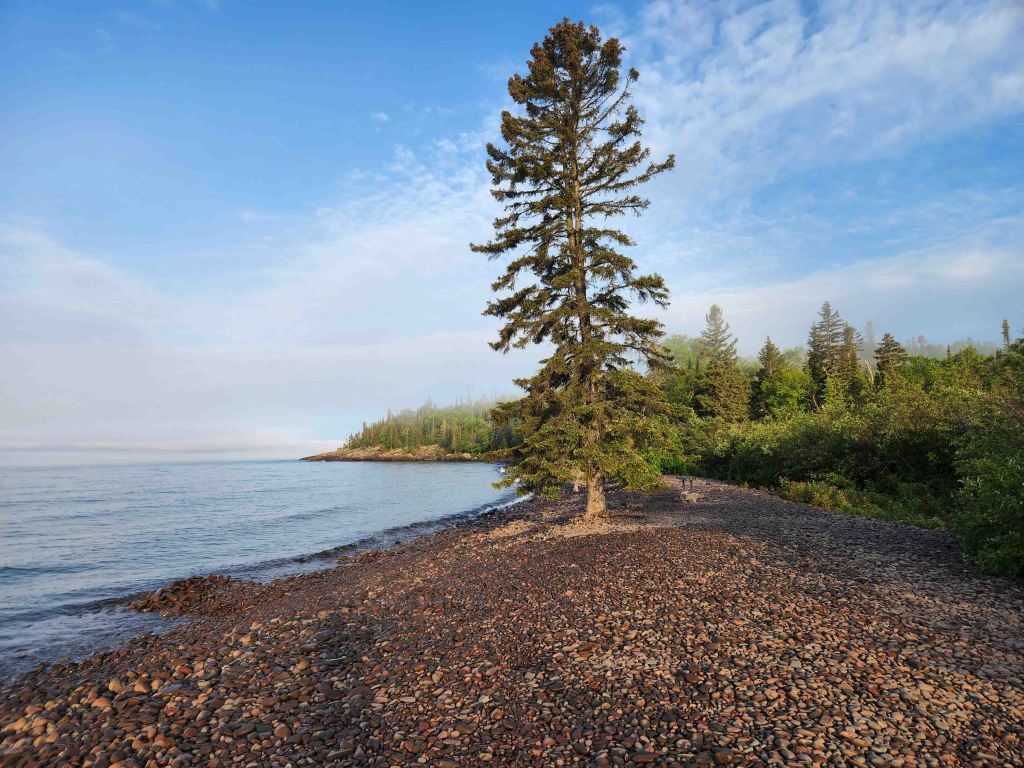
North Shore Scenic Byway
- Northern Terminus: Canadian Border 5 miles north of Grand Portage, MN
- Southern Terminus: Duluth, MN
- Road: US-61
- Distance: 154 miles
- Designation: All-American Road, HOG 50 Rides 1 Nation
- First Ride: Jul 2022 on 2012 H-D Streetglide
- Synopsis: Part of Lake Superior Circle Tour, it follows the Lake Superior Shoreline with access to numerous beaches, Superior Natl Forest, and 8 state parks
- Personal Highlights: Camping in Grand Marais Campground, Grand Portage Natl Monument, Grand Marais Harbor (photo), Angry Trout Café, Tettegouche State Park, Palasade Head Overlook, Black Beach, Sugar Loaf Nature Center

MISSISSIPPI

Natchez Trace Parkway
- Northern Terminus: Intersection of TN-100 and Natchez Trace Parkway south of Nashville, TN
- Southern Terminus: Natchez, MS
- Road: Natchez Trace Parkway
- Designation: All-American Road, National Park Service Historic Scenic Byway, HOG 50 Rides 1 Nation
- Distance: 444 miles
- First Ride: Sep 2012 on 2012 H-D Streetglide
- Synopsis: This two-lane road, devoid of commercial vehicles and traffic lights, follows the historic Native American Natchez Trace through 3 states and numerous historic and cultural sites
- Personal Highlights: Natchez Natl Historical Park, Sunken Trace, Reservoir Overlook, Cypress Swamp, Ross Barnett Reservoir, Brices Cross Roads Natl Battlefield, Mississippi Final Stands Interpretive Center, and side trips to Tupelo and Vicksburg Natl Military Park

MISSOURI

Historic Route 66 – St. Louis Section
- Western Terminus: Intersection of MO-366 (Old Rte 66) and River Des Peres Drainage Channel
- Eastern Terminus: Chain of Rocks Bridge [Both termini are within present-day St. Louis, MO city limits]
- Roads: Several Old Route 66 sections of pavement and present-day roads make up the multiple alignments of this historic route
- Distance: Approx. 30 miles
- Designation: National Scenic Byway and All-American Road
- First Ride: Jul 2022 on 2012 H-D Streetglide
- Synopsis: Old Route 66 roads vary from crumbling two-lane pavement to smooth interstate highways that vary depending on which of the multiple alignments you follow (course changed numerous times over the years that it was an active route); each alignment of the route is a part of Americana and road trip culture: neon signs, diners, motels, nostalgic gas stations, and “giants.”
- Personal Highlights: Side trip to ride up the Gateway Arch and Old Courthouse, Ted Drewes Ice Cream (photo), and Chain of Rocks Bridge

MONTANA
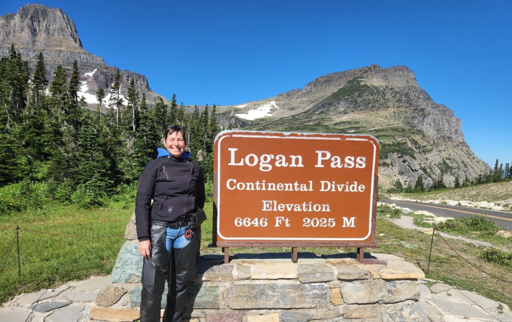
Going-to-the-Sun Road
- Western Terminus: Glacier Natl Park Entrance in West Glacier, MT
- Eastern Terminus: St. Mary, MT
- Road: Going-to-the-Sun Road
- Distance: 50 miles
- Designation: National Park Service Scenic Road, National Park Service Roads (fees involved), HOG 50 Rides 1 Nation
- First Ride: Aug 2022 on 2012 H-D Streetglide
- Synopsis: Two-lane road full of twisties and hairpin turns, with several pull-outs for viewing the northern Rocky Mountains and the Flathead River; includes waterfalls, glaciers, lakes, and valleys.
- Personal Highlights: Camping in West Glacier KOA Resort, Lake McDonald, The Loop, Logans Pass (6,646 ft), Bird Woman Falls, Hidden Lake Trail, Wild Goose Island, and grilled trout lunch at Two Dog Flats Grill
NEBRASKA
I’ve ridden through Nebraska, in transit to another state, but haven’t ridden any noteworthy routes yet.
NEVADA

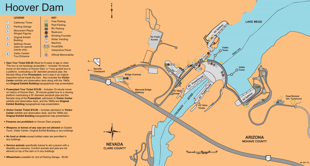
Hoover Dam
- Termini: Nevada/ Arizona border on I-11/ US-93 (now an out-and-back)
- Road: I-11 (formerly US-93)
- Distance: 1,244 feet
- Designation: Local favorite
- First Ride: Oct 2007 on 2006 H-D Sportster
- Synopsis: Two-lane road atop the 726-ft tall concrete arch gravity Hoover Dam with commanding views of Black Canyon and the Colorado River which forms Lake Meade
- Personal Highlights: Riding across the Hoover Dam when it was a segment of US-93 (and you could still transit from Arizona to Nevada over it); **NOTE: Thru-traffic is now diverted over the Mike O’Callaghan – Pat Tillman Memorial Bridge (Hoover Dam Bypass) since it was opened in 2010.
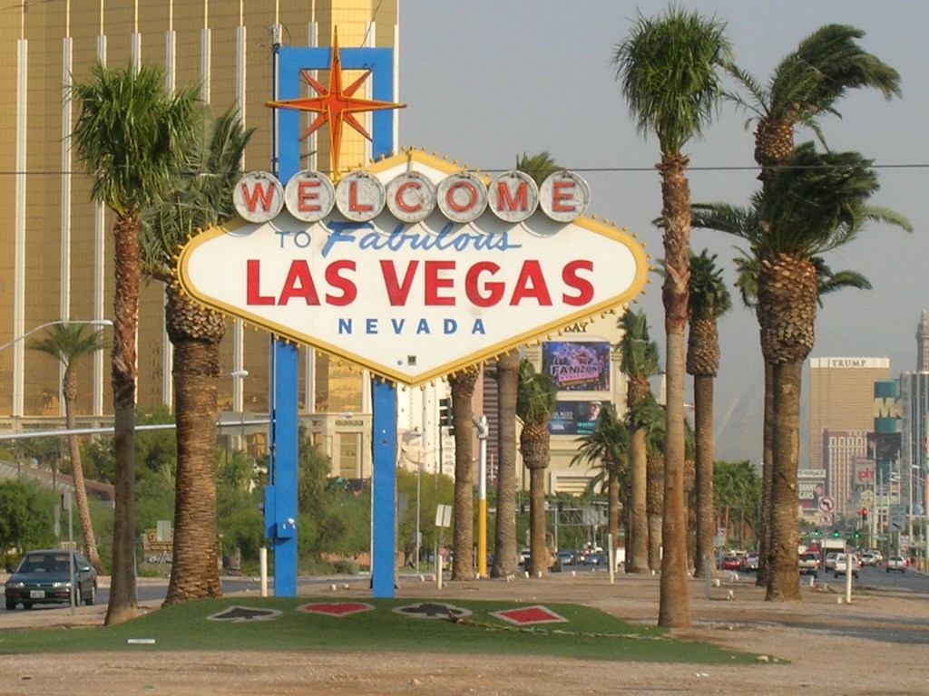
Las Vegas Strip
- Northern Terminus: Intersection of Russel Rd. and Las Vegas Blvd In Las Vegas, NV
- Southern Terminus: Intersection of Sahara Ave. and Las Vegas Blvd in Las Vegas, NV
- Road: Las Vegas Blvd.
- Distance: 4.5 miles
- Designation: All-American Road
- First Ride: Oct 2007 on 2006 H-D Sportster
- Synopsis: “One of America’s only nighttime byways and possibly the most concentrated collection of neon and lights in the world”. . . and traffic congestion. Be prepared to ride your clutch for miles!
- Personal Highlights: Harley-Davidson Café, Planet Hollywood Hotel, Cirque de Sole and Blue Man Group shows, and evening water fountain show at The Bellagio

NEW HAMPSHIRE

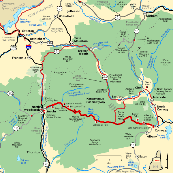
Kancamagus Highway
- Western Terminus: Lincoln, HH
- Eastern Terminus: Conway, NH
- Road: NH-112
- Distance: 26.5 miles
- Designation: National Scenic Byway, HOG 50 Rides 1 Nation
- First Ride: Jun 2022 on 2012 H-D Streetglide
- Synopsis: Two-lane road full of sweepers, and a few hairpin turns, that passes through the heart of the White Mountains while traversing the flank of Mt. Kancamagus; filled with scenic areas and overlooks of the White Mountain Natl Forest
- Personal Highlights: Russell Colbath Historic Site, camping in Jigger Johnson Campground, Swift River and Pemigewasset River, and Kancamagus Pass (2,855 ft)
NEW JERSEY

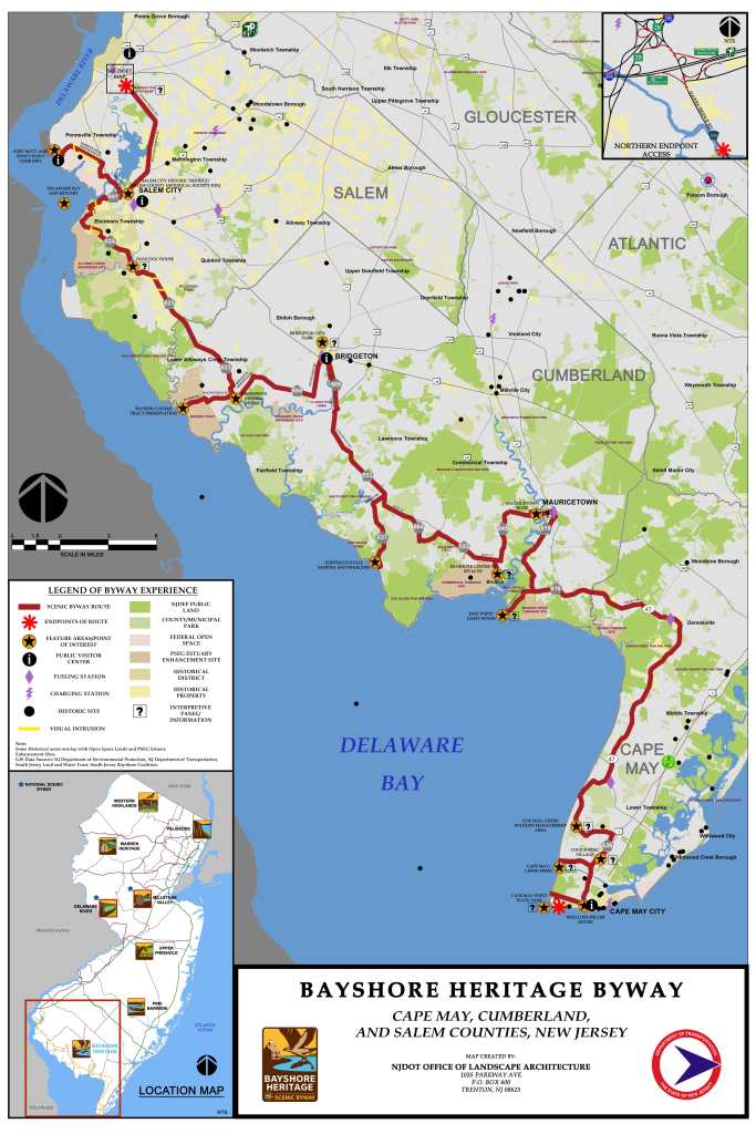
Bayshore Heritage Byway
- Northern Terminus: Mannington Township in Salem County
- Southern Terminus: Cape May State Park
- Roads: CR-661, CR-623, CR-624, CR-650, CR-609, CR-553, CR-637, CR-664, CR-553, CR-649, CR-616, NJ-47, CR-626
- Distance: 142 miles
- Designation: National Scenic Byway, HOG 50 Rides 1 Nation
- First Ride: Jul 2023 on 2022 H-D Heritage
- Synopsis: Two-lane roads that “wind their way through open farmland and quaint villages, seeing ship captains’ homes and Victorian architectural influences, culminating in the elaborate seaside resort homes of Cape May”
- Personal Highlights: Cape May Lighthouse (photo), and small coastal towns

Pine Barrens Scenic Byway
- Northern Terminus: Batsto Village, NJ
- Southern Terminus: Dennisville, NJ
- Roads: Three different routes covered by multiple roads
- Distance: 130 miles
- Designation: National Scenic Bayway
- First Ride: Jul 2023 on 2022 H-D Heritage
- Synopsis: Two-lane roads passing through The Pine Barrens (a UNESCO designated biosphere) located in the Pinelands Natl Reserve, that travels through a mosaic of forests, farms, rivers, streams and towns
- Personal Highlights: Pinelands Natl Reserve, Estell Manor Park, and Great Egg Harbor River (photo)

NEW MEXICO
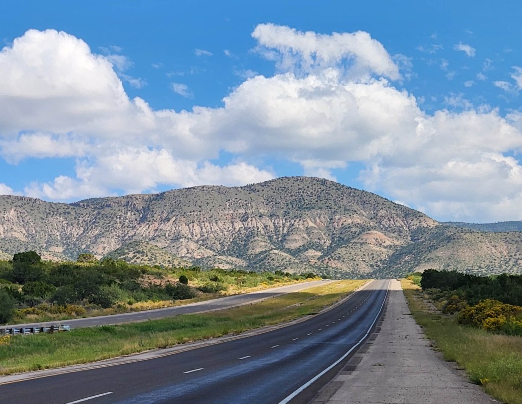
Billy the Kid Scenic Byway
- Western Terminus: Ruidoso, MN
- Eastern Terminus: Hondo, NM
- Roads: US-70, NM-48, NM-220, US-380
- Distance: 84 miles
- Designation: National Scenic Byway
- First Ride: Sep 2022 on 2022 H-D Heritage
- Synopsis: Route traverses the million-acre Lincoln Natl Forest through grassy plains to dense pine forests full of stunning views; goes through historic Lincoln, once home to outlaw Billy the Kid and lawman Pat Garrett.
- Personal Highlights: View of Sacramento Mountain Range foothills on US-70 approach to Mescalero (photo), lunch at K-Bob’s steakhouse, and side trip to Roswell UFO Museum

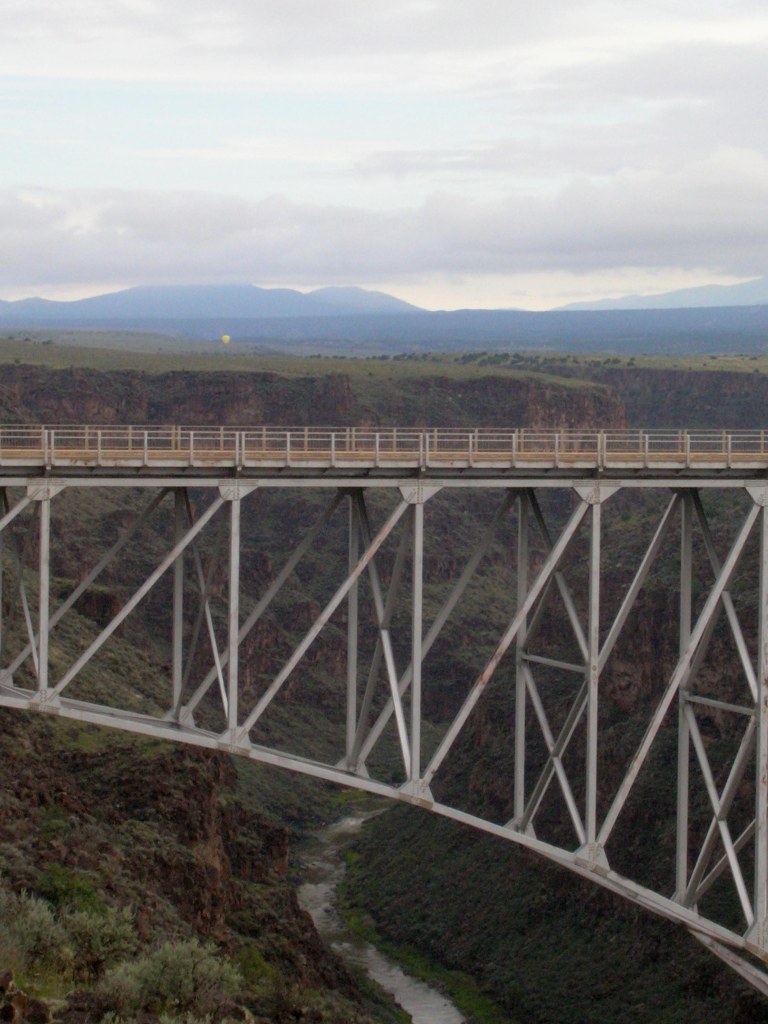
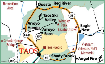
Enchanted Circle Scenic Byway
- Termini: Questa, NM (loop around Wheeler Peak and surrounding area)
- Roads: NM-522, NM-38
- Distance: 83 miles
- Designation: New Mexico State Scenic Byway, HOG 50 Rides 1 Nation
- First Ride: Sep 2006 on 2006 H-D Sportster
- Synopsis: Two-lane highways traversing classic alpine landscapes and scenery reminiscent of old Western cinema
- Personal Highlights: Old western town main street in Red River, Vietnam Veterans Natl Memorial, adobe architecture in Taos, and side trip to Rio Grande Gorge Bridge (photo)
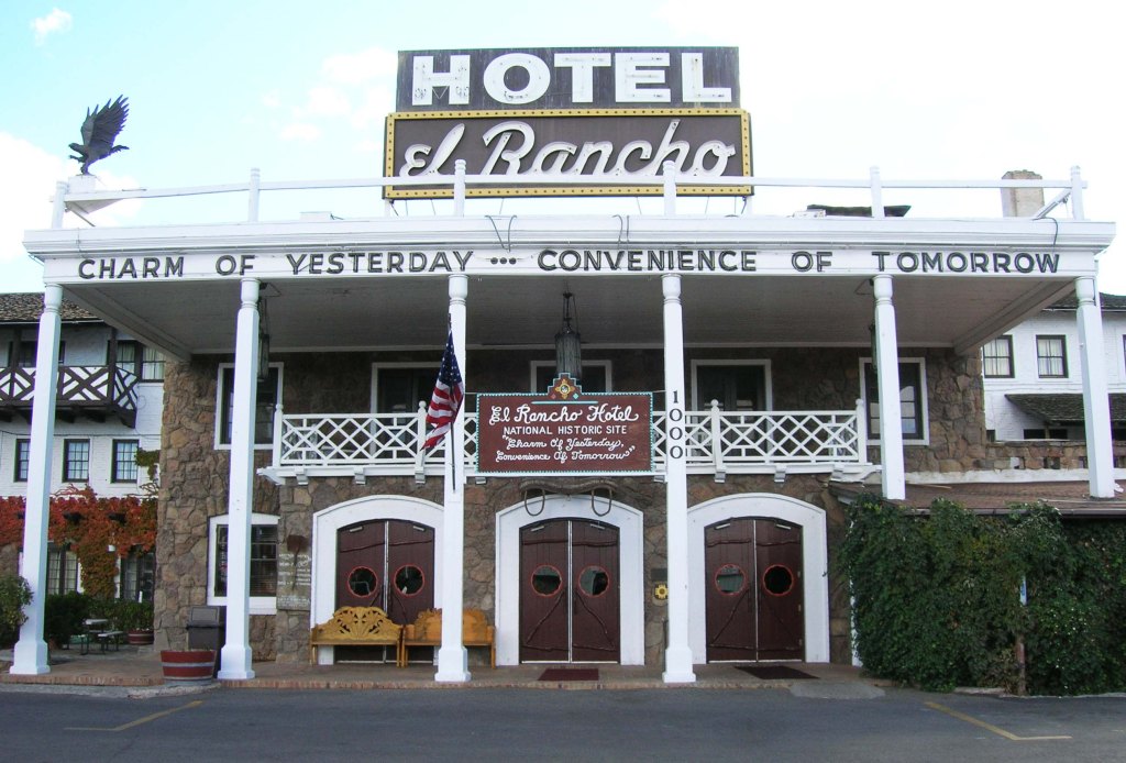
Historic Route 66 – New Mexico
- Western Terminus: West of Gallup, NM
- Eastern Terminus: Genrio, TX
- Road: Several old Route 66 sections of pavement and present-day roads make up the multiple alignments of this historic route
- Distance: 535 miles
- First Ride: Oct 2007 on 2006 H-D Sportster
- Synopsis: Old Route 66 roads vary from crumbling two-lane pavement to smooth interstate highways that vary depending on which of the multiple alignments you follow (course changed numerous times over the years that it was an active route); each alignment of the route is a part of Americana and road trip culture: neon signs, diners, motels, nostalgic gas stations, and “giants.”
- Personal Highlights: Hotel el Rancho (photo) where the naive registration clerk allowed me to park my bike overnight in the actual lobby (!), and crossing the Continental Divide

NEW YORK
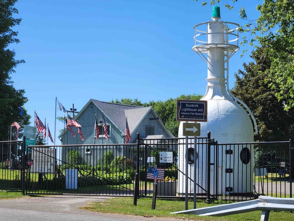
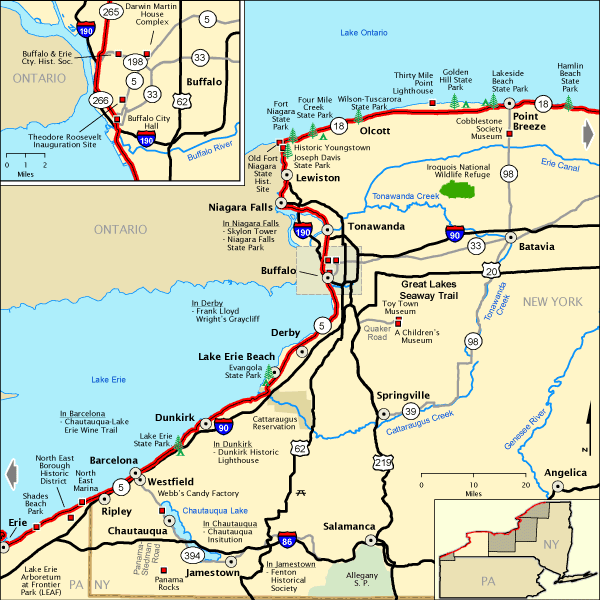
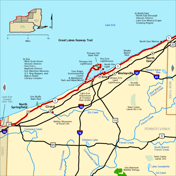
Great Lakes Seaway Trail – New York
- Western Terminus: Ohio-Pennsylvania state line approx. 27 miles west of Erie, PA
- Eastern Terminus: Seaway International Bridge at Massena, NY
- Roads: NY-5 and multiple roads through NY
- Distance: 454 miles
- Designation: National Scenic Byway
- First Ride: Jun 2022 on 2012 H-D Streetglide
- Synopsis: Road system following the shores of Great Lakes Erie and Ontario with access to beaches, museums, lighthouses, small towns and big cities
- Personal Highlights: Scenic beach overlooks and Dunkirk Lighthouse (photo)
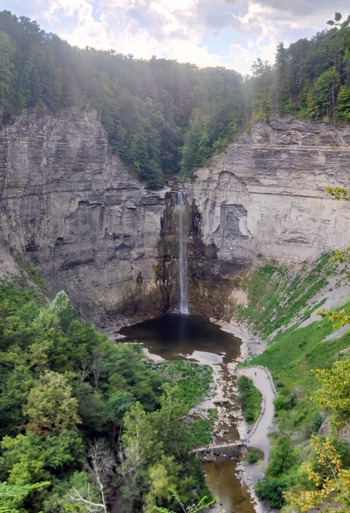
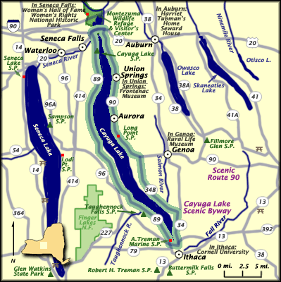
Cayuga Lake Scenic Byway
- Loop: Around Cayuga Lake
- Roads: NY-90, NY-348, NY-34, NY-89, US-20
- Distance: 86 miles
- Designation: HOG 50 Rides 1 Nation, New York State Scenic Byway
- First Ride: Aug 2025 on H-D Heritage
- Synopsis: Road system following the shore of Cayuga Lake, passing through farmlands, vineyards, and small lake towns.
- Personal Highlights: Taughannock Falls (photo) and side trip to Ithaca
Upper Delaware Scenic Byway
- Northern Terminus: Hancock, NY
- Southern Terminus: Port Jervis, NY
- Road: NY-97
- Distance: 53 miles
- Designation: New York State Scenic Byway
- First Ride: Jun 2021 on 2012 H-D Streetglide
- Synopsis: Two-lane curvy road that parallels the NY side of the southern portion of the Upper Delaware Scenic and Recreational River; provides glimpses of sweeping vistas and cliff overlooks.
- Personal Highlights: Hawks Nest, camping in Landers Campground for Babes Ride Out event with friends and 600+ women riders, and Narrowsburg-Darbytown Bridge (photo)

NORTH CAROLINA

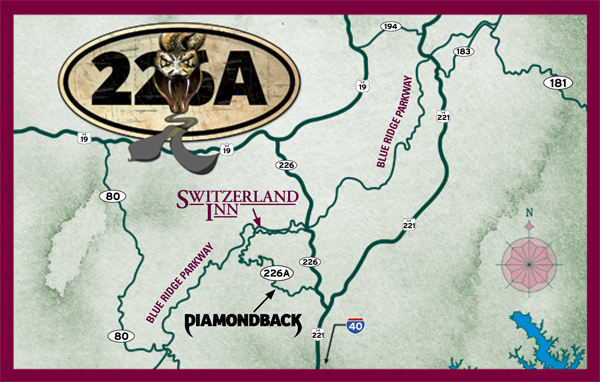
Diamondback
- Northern Terminus: Intersection of NC-226 and NC-226A approx. 3 miles east of Little Switzerland, NC
- Southern Terminus: Intersection of NC-226 and US-221 approx. 9 miles north of Marion, NC
- Road: NC-226A, NC-226
- Distance: 12 miles
- First Ride: Sep 2018 on 2012 H-D Streetglide (photo is from 2023 on 2022 H-D Heritage)
- Synopsis: Two-lane road with more than 190 steep, twisty, and hairpin curves in just 12 miles.
- Personal Highlights: Lunch at Switzerland Café and General Store (photo) and side trip to Blue Ridge Parkway

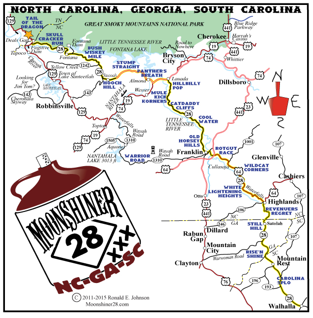
Moonshiner 28 (aka Hellbender 28)
- Western Terminus: Intersection of US-129 and NC-28 at Deals Gap, NC
- Eastern Terminus: Intersection of SC-28 and SC-183 in Walhalla, SC
- Roads: NC-28, US-64
- Distance: 103 miles
- Designation: Local Favorite, HOG 50 Rides 1 Nation
- First Ride: Sep 2012 on 2012 H-D Streetglide (photo is in 2025 on 2022 H-D Heritage)
- Synopsis: Two-lane road with lots of twisties and sweepers that follows old moonshine running route through Nantahala Natl Forest and three states (GA, NC, SC)
- Personal Highlights: Fontana Dam, Iron Horse Motorcycle Lodge, Dry Falls, Bridal Veil Falls (photo), and riding with friends numerous times over the years

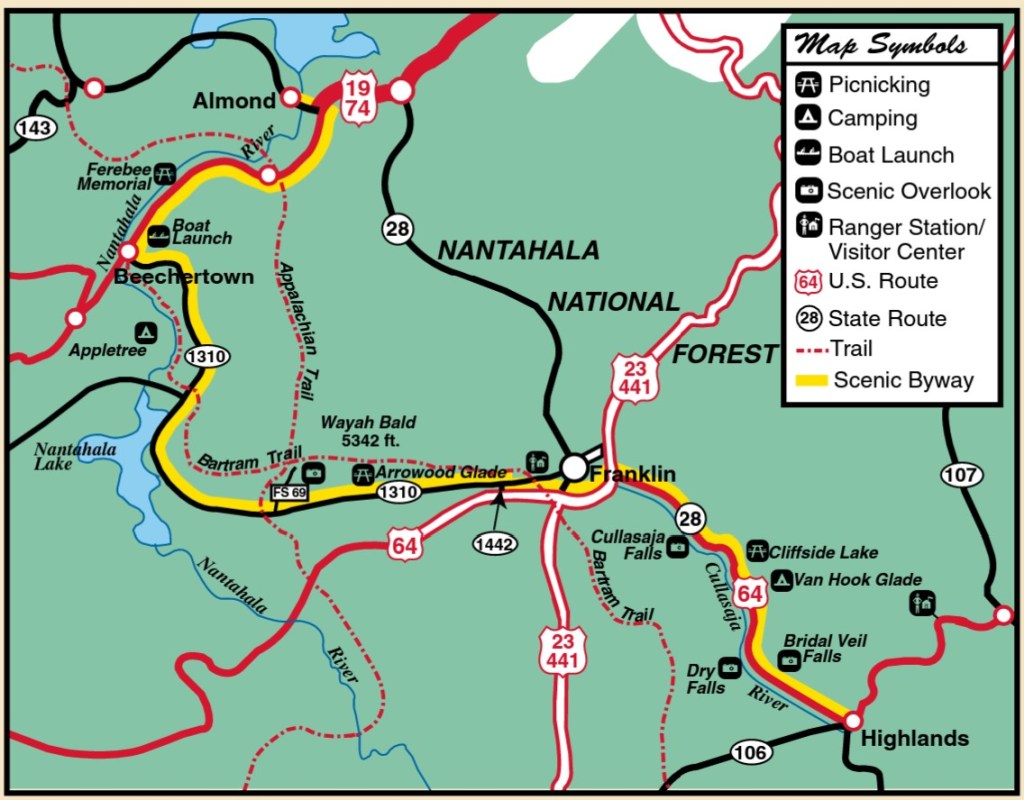
Mountain Waters Scenic Byway
- Northern Terminus: Almond, NC
- Southern Terminus: Highlands, NC
- Roads: US-74, NC-1310, NC-28, US-64
- Distance: 61 miles
- Designation: North Carolina Scenic Byway
- First Ride: Jul 2023 on 2022 H-D Heritage
- Synopsis: Narrow two-lane road, full of tight twisties, takes you past gorges, waterfalls, mountain streams, lakes, and trails through Nantahala National Forest; a section of Moonshiner 28 is part of route; one of my all-time favorite rides!
- Personal Highlights: Wayah Road, Dry and Bridal waterfalls, lunch at Lakes End Café and Grill (photo), and Nantahala Outdoor Center

Outer Banks Scenic Byway
- Northern Terminus: Whalebone Junction near Nags Head, NC
- Southern Terminus: Beaufort, NC
- Roads: NC-12, US-70
- Distance: 138 miles
- Designation: National Scenic Byway
- First Ride: Aug 2012 on 2012 H-D Streetglide
- Synopsis: Two-lane highway spanning three barrier islands (Hatteras, Ocracoke, and Cedar) that separate the Atlantic Ocean from Pamlico Sound, with ferry crossings, bridges, lighthouses, beach towns, and numerous national and state historical sites
- Personal Highlights: First road trip on 2012 H-D Streetglide, Bodie Island, Cape Hatteras, and Ocracoke Lighthouses, Oregon Inlet Lifesaving Station, Pea Island and Cedar Island Natl Wildlife Refuges, and side trip to Jennette’s Pier


Rattler
- Northern Terminus: Hot Springs, NC
- Southern Terminus: Intersection of US-74 and NC-209 near Lake Janaluska
- Road: NC-209
- Distance: 33 miles
- Designation: Local favorite
- First Ride: Sep 2018 on 2012 H-D Streetglide
- Synopsis: Two-lane road with leisurely straightaways through farmland valleys, broken up with twisties and hairpin turns through mountain terrain. Watch out for loose livestock on the road!
- Personal Highlights: Ferguson Supply and watching Appalachian Trail thru-hikers in Hot Springs
NORTH DAKOTA
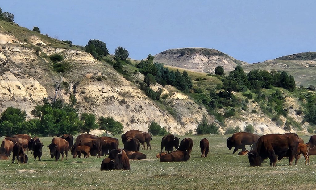
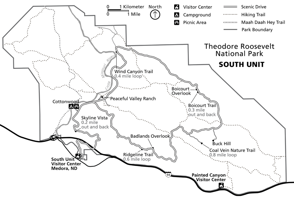
Theodore Roosevelt National Park Scenic Drive
- Termini: South Unit Visitors Center in Medora, ND (with loop through south unit of the National park)
- Road: East River Road, Scenic Loop Drive
- Distance: 48 miles
- Designation: National Park Scenic Drive, National Park Service Roads (fees involved), HOG 50 Rides 1 Nation
- First Ride: Jul 2023 on 2012 H-D Streetglide
- Synopsis: Two-lane paved, twisty loop with sweeping views of the Little Missouri River, forests, prairies, grasslands, unique Badlands geologic formations and lots of opportunities to encounter wildlife
- Personal Highlights: Prairie Dog Town, Skyline Vista, bison herds (photo), Boicourt and Badlands Overlooks, Dakota Prairie Grasslands, and camping in Buffalo Gap Campground
OHIO

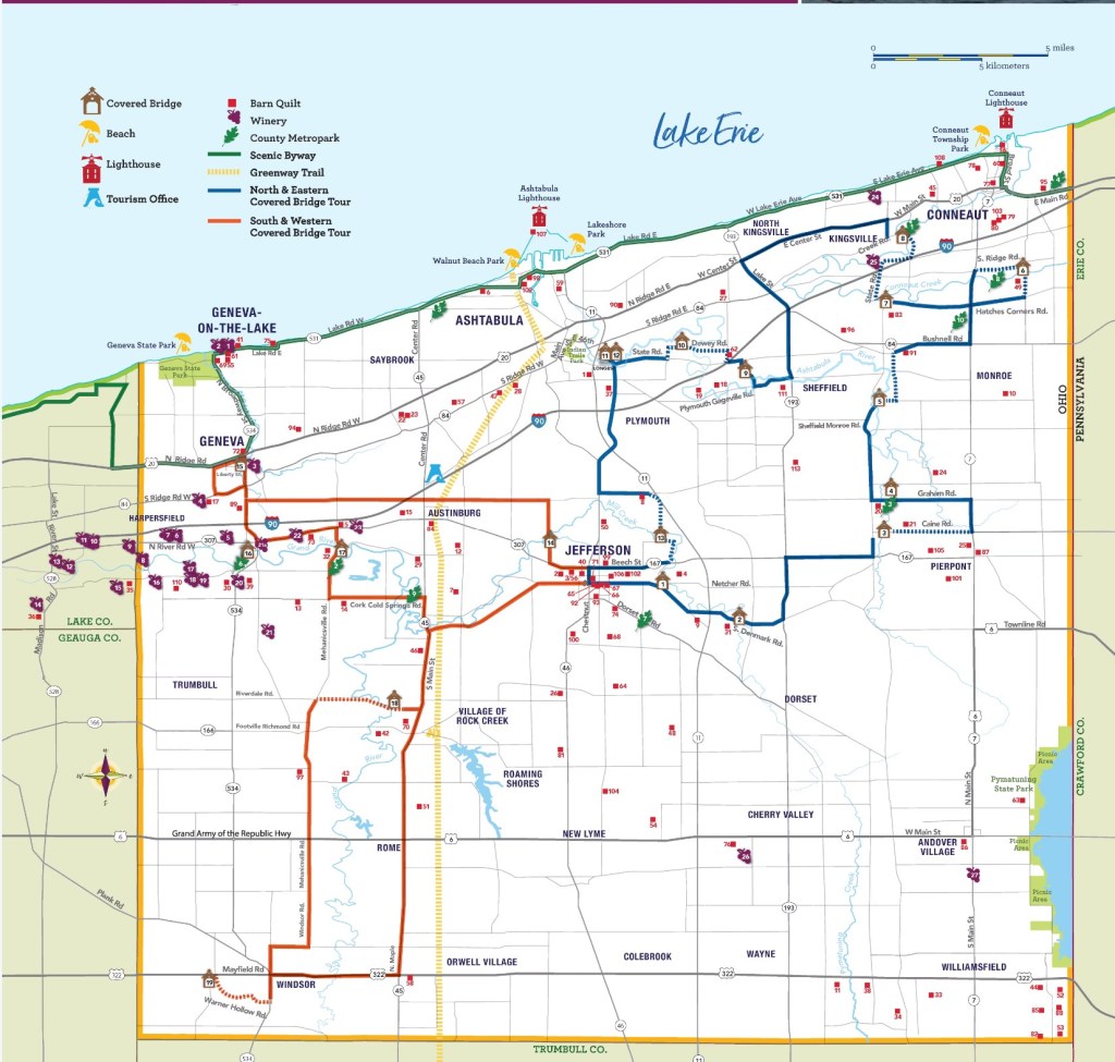
Ashtabula County Covered Bridges Driving Tour
- Northern Terminus: Coneaut, OH
- Southern Terminus: Windsor, OH
- Roads: Multiple throughout Ashtabula County
- Distance: 137 miles
- Designation: Local favorite
- First Ride: Jun 2022 on 2012 H-D Streetglide
- Synopsis: Two-lane country roads that lead to 19 covered bridges; route overlaps with winery and barn quilt trails
- Personal Highlights: Riding across the shortest (18 ft) and longest (613 ft – photo) covered bridges in the U.S. (according to Ashtabula County Visitors Bureau)
OKLAHOMA

Talimena Scenic Drive
- Western Terminus: Talihinia, Oklahoma
- Eastern Terminus: Mena, Arkansas
- Roads: OK-1, AR-88
- Distance: 54 miles
- Designation: National Scenic Byway, HOG 50 Rides 1 Nation
- First Ride: Sep 2023 on 2022 H-D Heritage
- Synopsis: Two-lane mountain road that passes through Ouachita National Forest with numerous scenic overlooks.
- Personal Highlights: Pie at Queen Wilhelmina State Park Lodge, Oklahoma-Arkansas state line historic site (photo), and Panorama Vista

OREGON
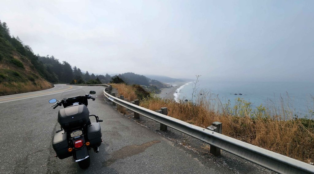
Pacific Coast Scenic Byway – Oregon
- Northern Terminus: Astoria, OR
- Southern Terminus: Brookings, OR
- Road: US-101
- Distance: 363 miles
- Designation: All-American Road
- First Ride: Aug 2022 on 2022 H-D Heritage
- Synopsis: Twisty two-lane road that winds past rockbound coast, ancient forests, and innumerable towns and villages with lots of pull-offs to view the Pacific Ocean; mostly cold and wet ride
- Personal Highlights: Fort Clatsop Natl Memorial, salmon dinners, Haystack Rock and Cannon Beach, boiled Dungeness crab at South Beach Grocery, Cape Perpetua, Devil’s Churn, Steve Prefontaine Memorials in Coos Bay, Battle Rock City Park, and side trip to Beaverton and Portland


Oregon Caves Entrance Road
- Western Terminus: Intersection of US-199 and OR-46 near Oregon Caves Illinois Valley Visitors Center
- Eastern Terminus: Terminus of OR-46 at Oregon Caves Tours and Visitors Center
- Road: OR-46
- Distance: 30 miles
- Designation: Happenstance 🙂
- First Ride: Aug 2022 on 2022 H-D Heritage
- Synopsis: Two-lane road full of twisties and hairpin turns. The whole of OR-46 is scenic, but that last 8-mile section before you hit the caves is an especially fun ride! It’s an out-and-back, so you get to ride it twice!
- Personal Highlights: Oregon Caves Natl Monument and Preserves (photo)


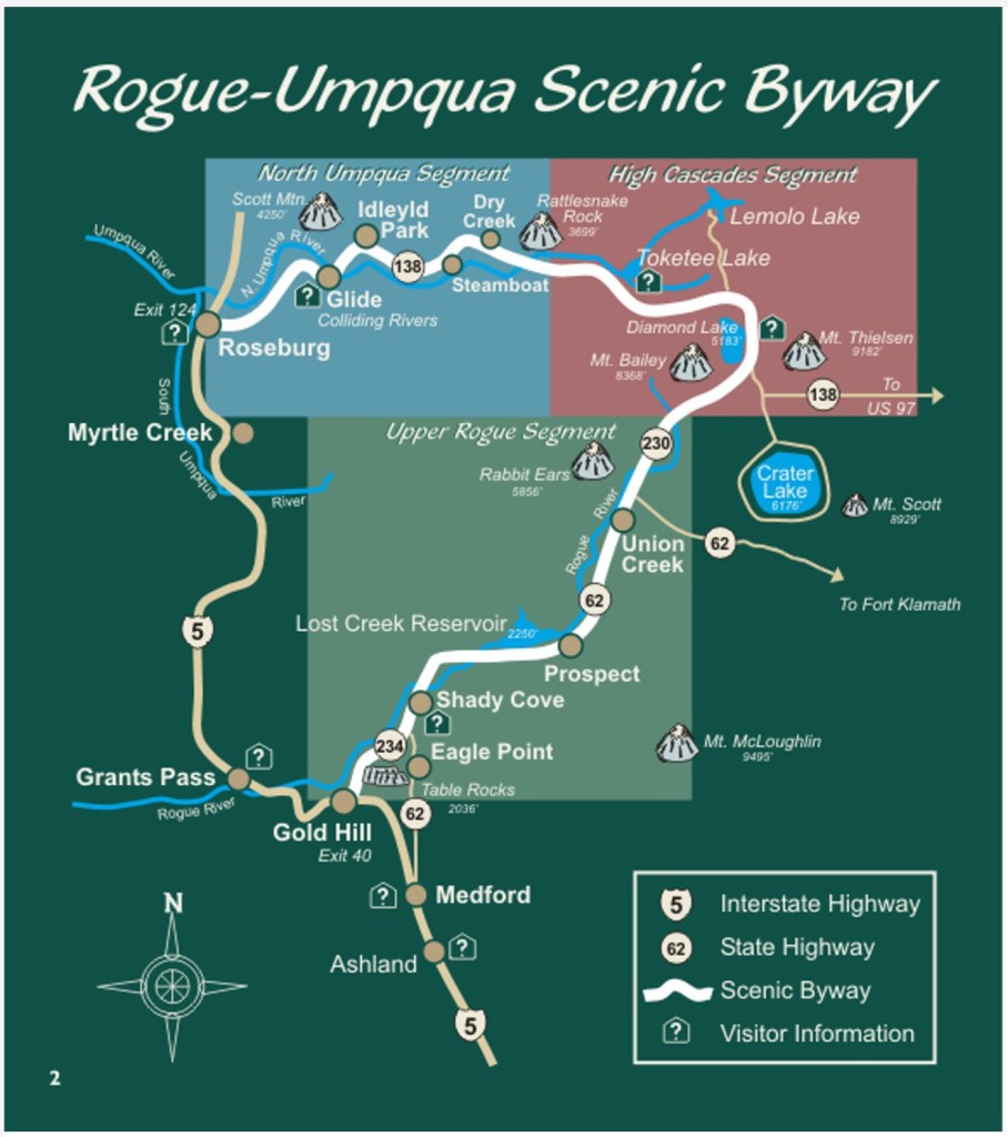
Rogue-Umpqua Scenic Byway
- Northern Terminus: Roseburg, OR
- Southern Terminus: Gold Hill, OR
- Roads: OR-138, OR-230, OR-62
- Distance: 172 miles
- Designation: National Scenic Byway
- First Ride: Aug 2022 on 2022 H-D Heritage
- Synopsis: Sweeping two-lane road traversing the Rogue River Valley with beautiful views of the Rogue River and Umpqua Natl Forest
- Personal Highlights: Of the Upper Rogue Segment- Prospect Historic Hotel, Pearsony Falls, Rogue River Gorge (photo), and side trip to Crater Lake National Park

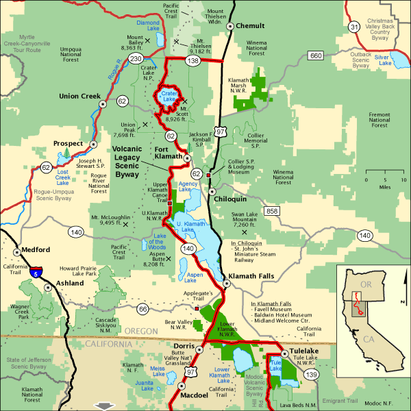
Volcanic Legacy Scenic Byway
- Northern Terminus: Intersection of US-97 and OR-138 approx. 10 miles south of Chemult, OR
- Southern Terminus: Intersection of CA-89 and CA-147 at Canyondam, CA
- Roads: US-97, OR-138, OR-62, OR-140, CA-89, CA-44, CA-36
- Distance: 500 miles
- Designation: All-American Highway, some roads are National Park Service Roads (fees involved)
- First Ride: Sep 2022 on 2022 H-D Heritage
- Synopsis: Two-lane roads wind through dramatic volcanic landscape, pristine lakes, and multiple Natl Park Service units
- Personal Highlights: Crater Lake Natl Park (photo), Klamath Lake, Tulelake Natl Monument, Tulelake Natl Wildlife Refuge, Lava Beds Natl Monument, and Lassen Volcanic Natl Park

US-26
- Western Terminus: Prineville, OR
- Eastern Terminus: Intersection of US-26 and OR-19 approx. 7 miles west of Dayville, OR
- Road: US-26
- Distance: 78 miles
- Designation: Butler Maps G1 Series Route
- First Ride: Sep 2022 on 2022 H-D Heritage
- Synopsis: Two-lane road full of twisties leading to, and connecting, the Painted Hills and Sheep Rock units of John Day Fossil Beds Natil Monument through the Ochoco Mountains and Natl Forest; fun road to ride!
- Personal Highlights: Ochoco Wayside State Park, Painted Hills Unit (photo), and Cant Ranch

PENNSYLVANIA
Great Lakes Seaway Trail – Pennsylvania
- Western terminus: Ohio-Pennsylvania state line approx. 27 miles west of Erie, PA
- Eastern terminus: Pennsylvania-New York state line approx. 20 miles east of Erie, PA
- Roads: US-20, PA-5,
- Distance: 65 miles
- Designation: National Scenic Byway
- First Ride: Jun 2022 on 2012 H-D Streetglide
- Synopsis: Road system following the shores of Great Lakes Erie and Ontario with access to beaches, museums, lighthouses, small towns and big cities
- Personal Highlights: Lakeshore pull-offs (photo)
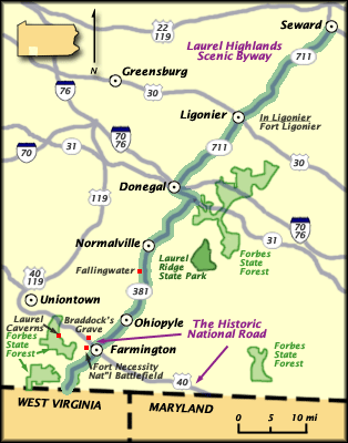
Laurel Highlands Scenic Byway
- Northern terminus: Seward, PA
- Southern terminus: Pennsylvania-West Virginia state line approx. 2 miles south of Springhill, PA
- Roads: PA-711, PA-381
- Distance: 68 miles
- Designation: HOG 50 Rides, 1 Nation, Pennsylvania State Scenicy Byway
- First Ride: Aug 2026 on 2022 H-D Heritage
- Synopsis: Two-lane state roads passing through landscapes of rolling hills, waterfalls, farmlands, and state parks.
- Personal highlight: Ohiopyle State Park (photo)
RHODE ISLAND
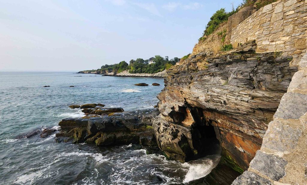
Ocean Road 1A
- Northern terminus: Narragansett, RI
- Southern terminus: Point Judith, RI
- Road: RI-1A, RI-108
- Distance: 6 miles
- Designation: HOG 50 Rides 1 Nation
- First Ride: Aug 2025 on 2022 H-D Heritage
- Synopsis: Two-lane scenic road that meanders coves and inlets of Atlantic Ocean coast
- Personal Highlights: Point Judith Lighthouse, side trip to Newport and Cliff Walk (photo) and lobster rolls
SOUTH CAROLINA

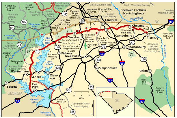
Cherokee Foothills Scenic Highway
- Western terminus: Fairplay, SC
- Eastern terminus: Gaffney, SC
- Road: SC-11
- Distance: 112 miles
- Designation: National Scenic Byway, HOG 50 Rides 1 Nation
- First Ride: Sep 2023 on 2022 H-D Heritage
- Synopsis: Straight, flat two-lane road that follows an ancient Cherokee path through peach orchards, farmland and villages, and past Cowpens Natl Battlefield, Table Rock State Park, and Lake Keowee; was disappointed in the lack of roadside info about historic Cherokee path for which the route is named
- Personal Highlights: Peachoid in Gaffney (photo), Table Rock State Park, and Cowpens National Battlefield

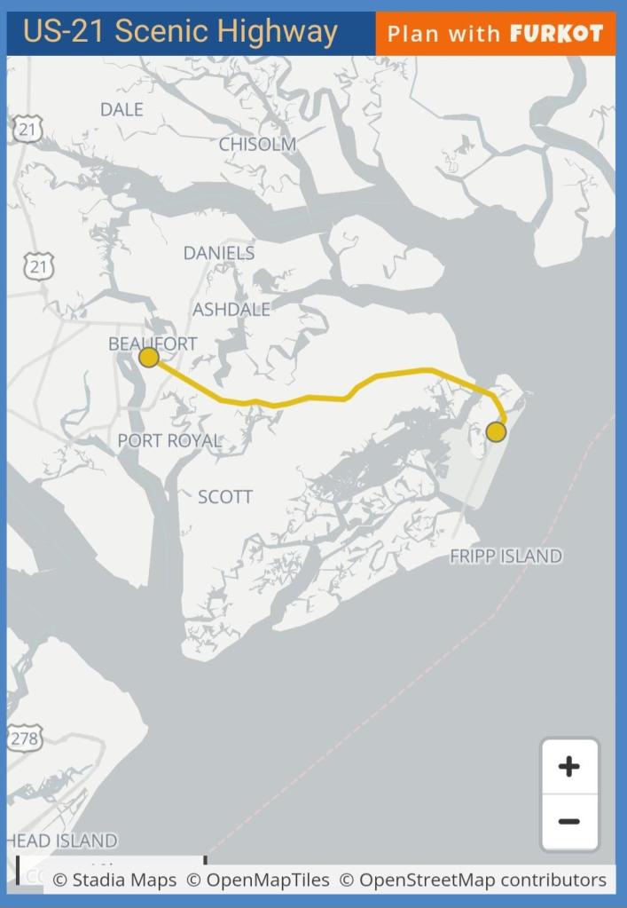
US-21
- Western terminus: East side of Richard V. Woods Memorial Bridge in Beaufort, SC
- Eastern terminus: Hunting Island State Park, SC
- Road: US-21
- Distance: 18 miles
- Designation: South Carolina State Scenic Byway
- First Ride: Mar 2024 on 2022 H-D Heritage
- Synopsis: Straight, flat two-lane road that cuts across St. Helena Island
- Personal Highlights: Reconstruction Era National Historical Park Penn Center, Hunting Island State Park
SOUTH DAKOTA
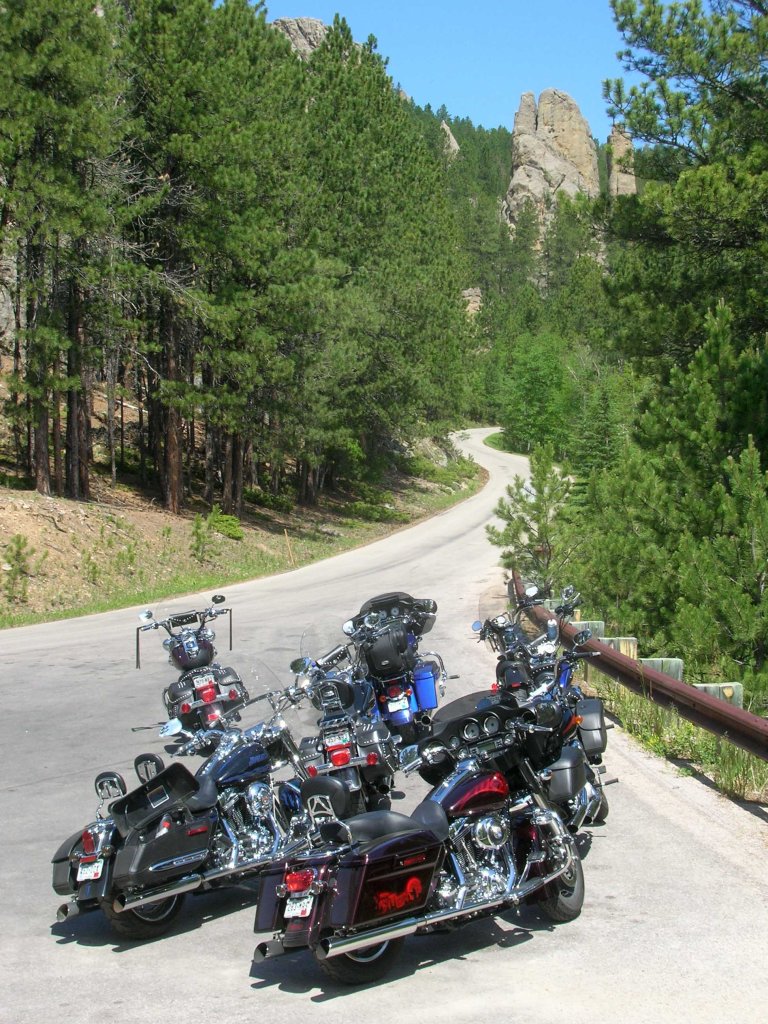
Peter Norbeck Natl Scenic Byway (Black Hills Loop)
- Termini: Custer, SD (double loop through Black Hills Natl Forest and Custer State Park)
- Roads: SD-89, SD-887, SD-244, US-16A, Alt US-16
- Distance: 68 miles
- Designation: Natl Scenic Byway
- First Ride: Jun 2007 on 2006 H-D Sportster
- Synopsis: This byway “winds its way around spiraling pig-tail shaped bridges, through six rock tunnels, among towering granite pinnacles and over pristine, pine-clad mountains;” a very hot ride in summer
- Personal Highlights: Mt. Rushmore, Harney Peak, Sylvan Lake, the Needles Eye Tunnel and Cathedral Spires rock formations (photo)

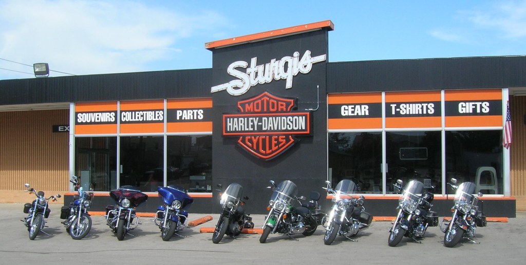
Spearfish Canyon Scenic Byway
- Northern Terminus: Spearfish, SD
- Southern Terminus: Savoy, SD
- Road: US-14 ALT
- Distance: 22 miles
- Designation: SD State Scenic Byway
- First Ride: Jun 2007 on 2006 H-D Sportster
- Synopsis: Two-lane “winding road that meanders through towering limestone cliffs, waterfalls, and abundant wildlife… breathtaking panoramic views, historic landmarks and scenic overlooks.”
- Personal Highlights: I rode this in a group and the lead didn’t stop anywhere along the route, so can’t pick out a highlight other than it was fun to ride! “Side trip” to Sturgis (photo)

TENNESSEE
Cherohala Skyway
- Western Terminus: Tellico Plains, TN
- Eastern Terminus: Robbinsville, NC
- Road: TN-165/NC-143
- Distance: 43 miles
- Designation: Natl Scenic Byway
- First Ride: Sep 2012 on 2012 H-D Streetglide
- Synopsis: Two lane road full of twisties and hairpin turns with lots of pullouts for views of Cherokee and Nantahala Natl Forests
- Personal Highlights: Santeetlah Overlook (5,390 ft), and Spirit Ridge Trail


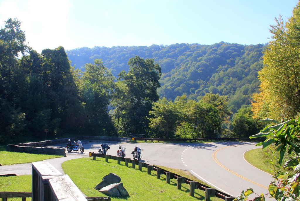
Foothills Parkway
- Northern Terminus: Wears Valley, TN
- Southern Terminus: Chilhowee, TN
- Road: Foothills Parkway
- Distance: 22 miles (only fully-completed section of designated 72-mile corridor)
- Designation: National Scenic Parkway
- First Ride: Jul 2023 on 2022 H-D Heritage
- Synopsis: Mostly sweeping, with some twisties, two-lane road that follows the Smoky Mountains ridgeline along the western edge of The Great Smoky Mountains Natl Park, providing panoramic mountain views
- Personal Highlights: Numerous scenic overlooks (photo) and side trips to Tail of the Dragon and The Great Smoky Mountains Natl Park

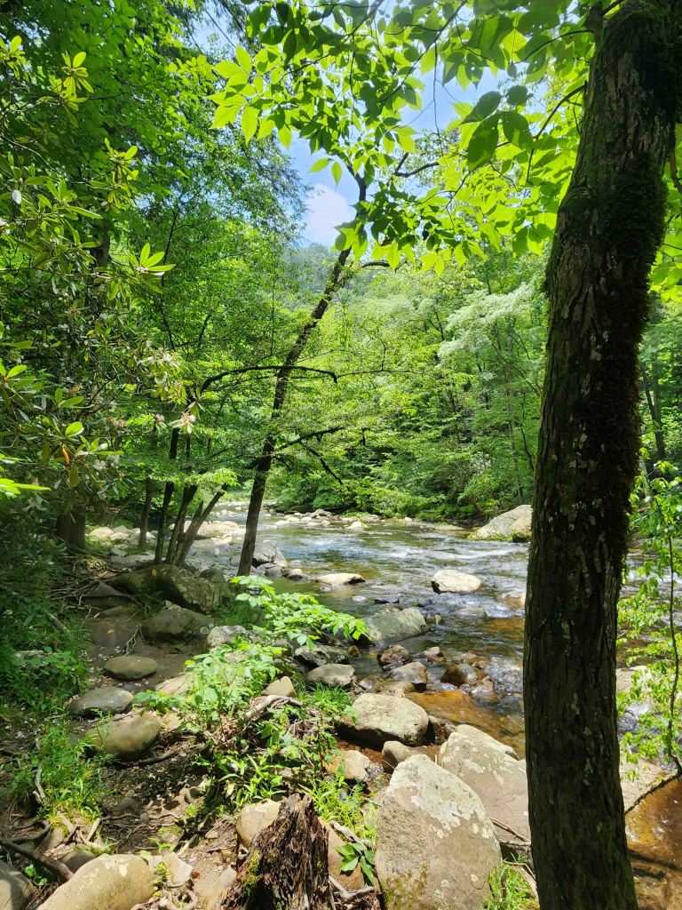
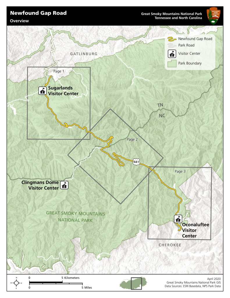
Newfound Gap Road Byway
- Western Terminus: Sugarlands Visitor Center in Great Smoky Mountains Natl Park
- Eastern Terminus: Oconaluftee Visitor Center in Great Smoky Mountains Natl Park
- Road: US-441
- Distance: 31 miles
- Designation: All-American Road, National Park Service Road (no fees involved to ride it, but fees for parking)
- First Ride: Jul 2023 on 2022 H-D Heritage
- Synopsis: Two-lane road full of mountain sweepers and twisties along creeks and streams, that runs the width of Smoky Mountain Natl Park; as the most visited Natl Park in the U.S., this road is almost always crowded
- Personal Highlights: Oconaluftee and Little Pigeon Rivers overlooks (photo) and Clingman’s Dome area
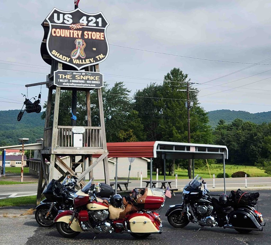
The Snake
- Western Terminus: Holston Valley, TN at the intersection of US-421 and TN-44
- Eastern Terminus: Just north of Mountain City, TN at the intersection of US-421 and Cold Spring Road
- Road: US-421
- Distance: 37 miles
- Designation: Local favorite
- First Ride: Aug 2023 on 2022 H-D Heritage
- Synopsis: Two-lane road billed as “489 curves, 1 valley and 3 mountains.” Full of twisties and a few hairpin turns traversing farmland, forest, and mountain scenery.
- Personal Highlights: The Country Store at Shady Valley (photo)


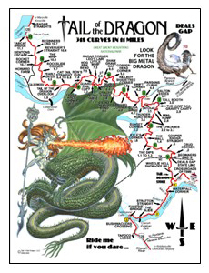
Tail of the Dragon
- Western Terminus: Tabcat Bridge at Chilhowee Lake near Chilhowee, TN
- Eastern Terminus: Intersection of NC-28 and US-129 near Deals Gap, NC
- Road: US-129
- Distance: 11 miles
- Designation: Local favorite, HOG 50 Rides 1 Nation
- First Ride: Sep 2012 on 2012 H-D Streetglide
- Synopsis: With 318 curves, this narrow two-lane road is a fun test of technical riding ability, full of twisties and hairpin turns, but watch out for inexperienced/reckless bikers and drivers drifting into oncoming lane; is often very crowded; there are professional photographers along the route to capture your ride
- Personal Highlights: Calderwood Overlook, and the Dragon Tree of Shame
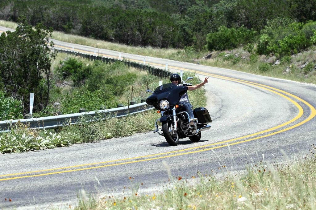
TEXAS

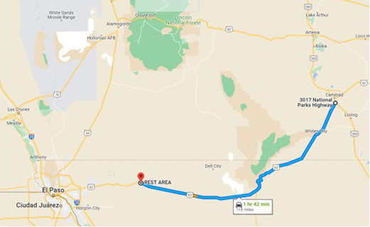
Highway 62/180 to the Guadalupes
- Western Terminus: Rest area on US-62/180 approx. 50 miles east of El Paso, TX
- Eastern Terminus: Carlsbad, NM at intersection of US-285 and US-62
- Road: US-62/180
- Distance: 118 miles
- Designation: National Park Service Scenic Drive (no fees involved)
- First Ride: Sep 2022 on 2022 H-D Heritage
- Synopsis: Isolated two-lane road through desert scenery providing breathtaking views of the Guadalupe Mountain from all directions, and of the salt flats, with numerous pull-offs and overviews.
- Personal Highlights: Pines Spring Visitors Center and Guadalupe Mountain Natl Park, and stunning long-range scenic views of Guadalupe Mountain (photo)
Twisted Sisters
- Western Terminus: Intersection of TX-55 and FM-337 at Camp Wood, TX
- Eastern Terminus: Intersection of TX-16 and TX-173 at Bandera, TX
- Roads: FM-335, FM-336, FM-337, TX-15, TX-41, US-83
- Distance: 100 miles
- Designation: Butler Maps G1 Series Route, HOG 50 Rides 1 Nation
- First Ride: Jun 2013 on 2012 H-D Streetglide
- Synopsis: Three, two-lane Farm-to-Market Roads (335, 336, and 337) full of twisties, sweepers, and a few hairpin turns through the Hill Country and along the Nueces and West Frio Rivers and ranches; professional photographers sometimes on route (photo); watch for gravel on road
- Personal Highlights: Frio Canyon Motorcycle Shop and lunch at the Bent Rim Grill, apple pie at the Apple Store, and side trips to Lone Star Motorcycle Museum, Stonehenge II at the Hill Country Art Foundation, and Lost Maples State Natural area


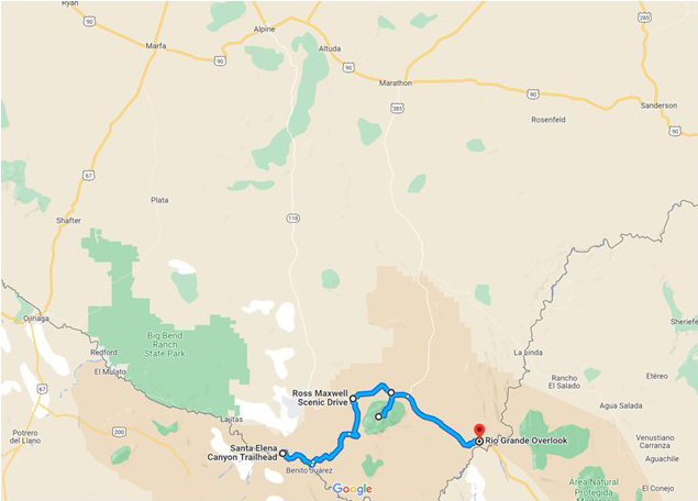
Big Bend National Park
- Western Terminus: Santa Elana Canyon Trailhead Parking Lot in Big Bend National Park
- Eastern Terminus: Rio Grand Overlook Parking Lot in Big Bend National Park
- Roads: Santa Elena Canyon Road, Ross Maxwell Scenic Drive, Gano Springs Road, Basin Junction Road, Park Route 12
- Distance: 75 miles
- Designation: National Park Scenic Drive, National Park Service Roads (fees involved)
- First Ride: Sep 2022 on 2022 H-D Heritage
- Synopsis: Two-lane NPS roads that include straight-aways and twisties (with 15% grade) through mountain peaks, arid desert, canyons, and river scenery through Big Bend Natl Park.
- Personal Highlights: Chisos Mountains (photo) and Lodge Restaurant, Sotol Vista, Mule Ears Overlook, Santa Elena Canyon, Rio Grande, Cerro Castellan, and Window View Trail

Willow City Wildflower Loop
- Termini: Willow City, TX (with loop through small section of Texas Hill Country)
- Roads: Willow City Loop Road, TX-16, CR-1323
- Distance: 35 miles
- Designation: Local Favorite
- First Ride: Mar 2014 on 2012 H-D Streetglide
- Synopsis: Somewhat maintained, paved narrow road through ranch country, lined by bluebonnets in the spring
- Personal Highlights: Texas Longhorn cattle ranches and boot fence (photo)

UTAH
Haven’t ridden in Utah. . . YET!
VERMONT
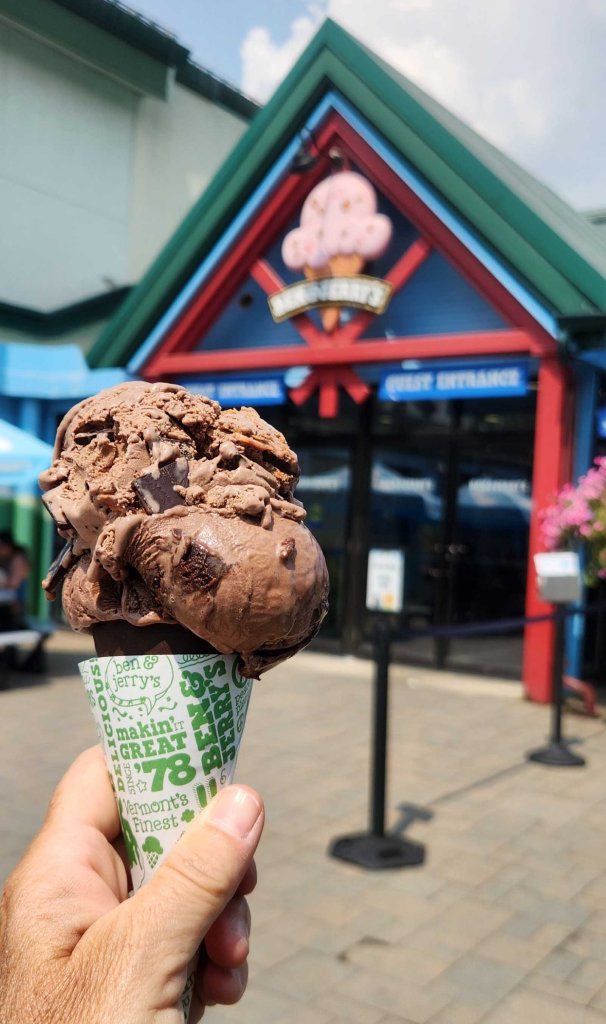
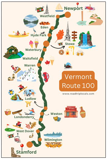
Scenic Route 100 Byway
- Northern Terminus: Newport, VT
- Southern Terminus: Stamford, VT
- Roads: VT-100
- Distance: 146 miles
- Designation: HOG 50 Rides 1 Nation, Vermont State Scenic Byway
- First Ride: Aug 2025 on 2022 H-D Heritage
- Synopsis: Two-lane state road traversing the eastern edge of the Green Mountains with lots of New England small towns and waterfalls
- Personal Highlights: The Vermonth Country Store, Moss Glen Falls, and Ben & Jerry’s Ice Cream Factory
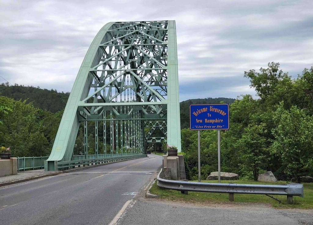
Connecticut River Byway (Vermont Section)
- Northern Terminus: Canada-US Border at US-3
- Southern Terminus: Vermont-Massachusetts Border at US-5
- Roads: US-3, VT-145, VT-102, US-2, US-135, VT-12A, VT-11,
- Distance: 225 miles (varies on route)
- Designation: National Scenic Byway
- First Ride: Jun 2022 on 2012 H-D Streetglide
- Synopsis: Mostly two-lane roads running parallel to Connecticut River and railroads through farmland and small towns
- Personal Highlights: Scenic views of Connecticut River and numerous VT-NH bridges (photo)
VIRGINIA
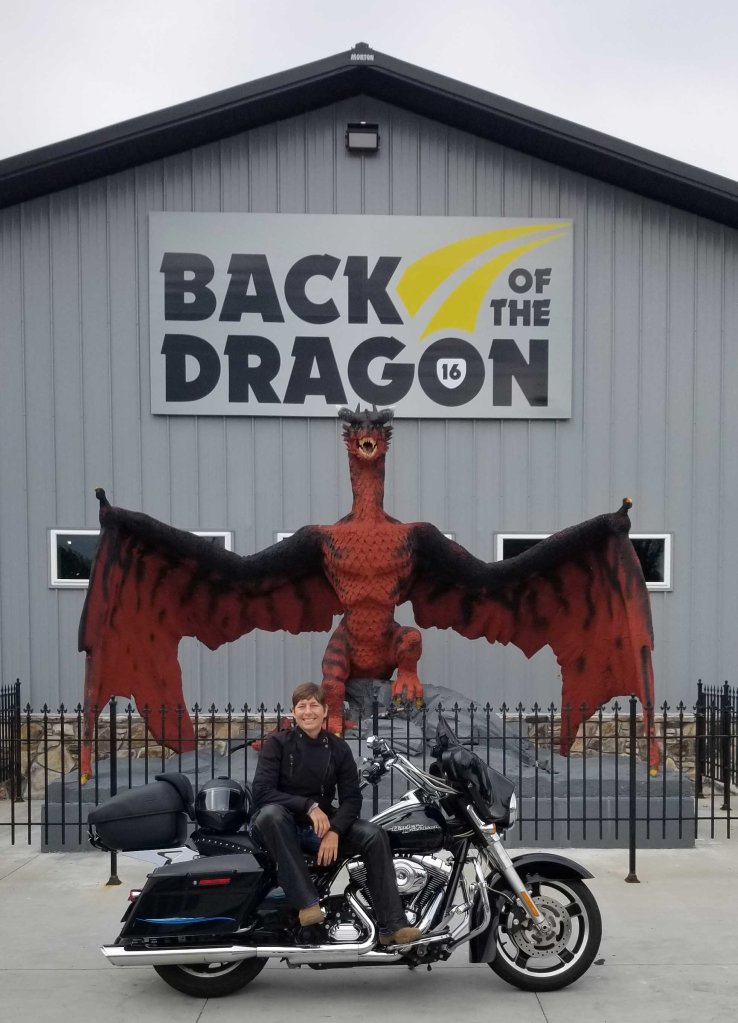
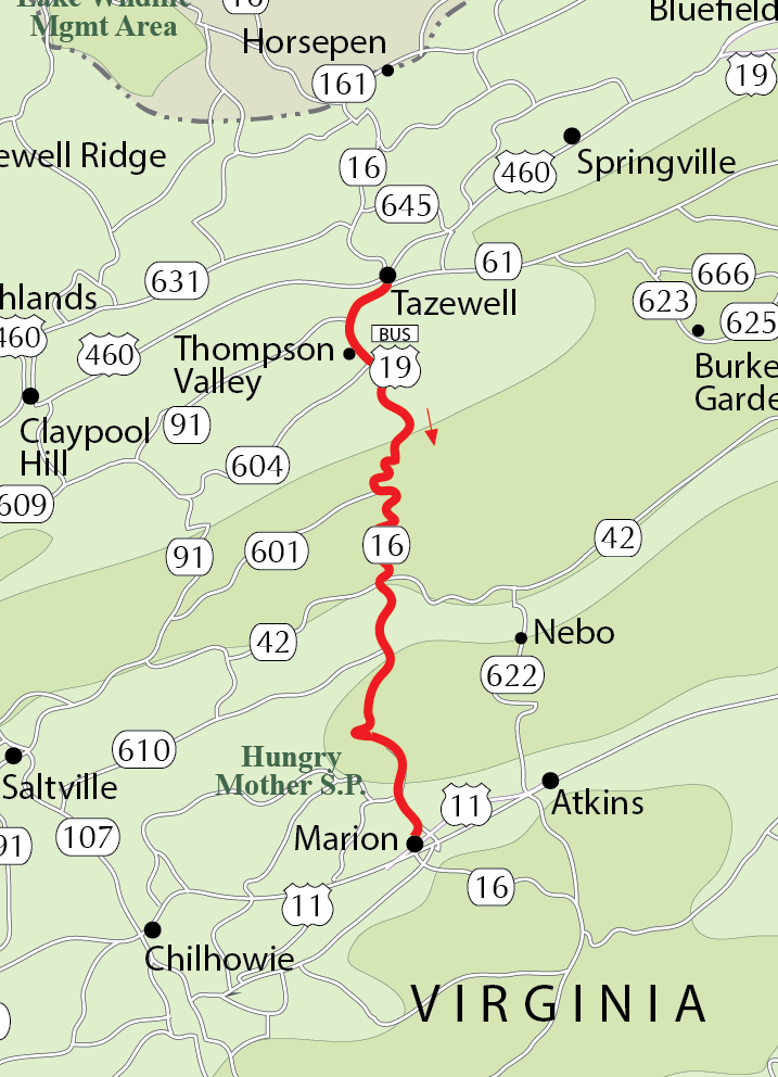
Back of the Dragon
- Northern Terminus: Tazewill, VA
- Southern Terminus: Marion, VA
- Road: VA-16, US-19A
- Distance: 32 miles
- Designation: Local favorite
- First Ride: Sep 2021 on 2012 H-D Streetglide
- Synopsis: Two-lane road passing through the Appalachian Mountains and Jefferson National Forest with 438 twisty, sweeping, and hairpin curves and 3,500 ft of elevation change, with just enough straightaways to take in a little scenery along the way
- Personal Highlights: Hungry Mother State Park, Walker Mountain Overlook, and Back of the Dragon store and coffee shop in Tazewell (photo)
Blue Ridge Parkway
- Northern Terminus: Rockfish Gap near Waynesboro, VA (connection point to Skyline Drive)
- Southern Terminus: Cherokee, NC
- Road: Blue Ridge Parkway
- Distance: 469 miles
- Designation: All-American Road
- First Ride: Sep 2012 on 2012 H-D Streetglide
- Synopsis: Two-lane road devoid of commercial vehicles and traffic lights, with moderate twisties and lots of scenic pull-offs. “The Parkway provides spectacular mountain and valley vistas, quiet pastoral scenes, sparkling waterfalls and colorful flower and foliage displays as it extends through the Blue Ridge Mountains of Virginia and North Carolina”
- Personal Highlights: Roanoke Mountain, Rocky Knob Campground and overlook (photo), Mabry Mill, Aunt Orelena Puckett Cabin Exhibit, Linn Cove Viaduct/Gorge/Falls, Mount Mitchell, Frying Pan Tower, Pisgah Inn, and so much more!

Skyline Drive
- Northern Terminus: Front Royal, VA
- Southern Terminus: Waynesboro, VA at entrance to Blue Ridge Parkway
- Road: Skyline Dr.
- Distance: 105 miles
- Designation: National Scenic Byway, National Park Service Roads (fees involved), HOG 50 Rides 1 Nation
- First Ride: Jun 2016 on 2012 H-D Streetglide
- Synopsis: Two-lane road devoid of commercial vehicles and traffic lights with moderate twisties and lots of scenic pull-offs that runs along the crest of the Blue Ridge Mountains and through the heart of Shenandoah Natl Park.
- Personal Highlights: Numerous scenic overlooks (photo)

WASHINGTON

Cascade Loop
- Terminus: Mukilteo, WA (unofficial start of loop through the state)
- Roads: WA-525, WA-20, WA-153, US-97, US-2
- Distance: 440 miles
- Designation: National Scenic Byway, HOG 50 Rides 1 Nation
- First Ride: Aug 2022 on 2022 H-D Heritage
- Synopsis: Billed as WA state’s ultimate road trip, this route delivers! Comprised of 3 of WA state’s scenic byways (North Cascades Hwy, Stevens Pass Greenway, and Whidbey Scenic Isle Way); one of my all-time favorite rides (except for the road construction at the time!)
- Personal Highlights: Ebey’s Landing, Deception Pass, North Cascades Natl Park, Diablo Lake (photo), Home Stream Park in Winthrop, Methow River, Knapp’s Hill Tunnel, Entiat, Bavarian pastries in Leavenworth, and Steven’s Pass


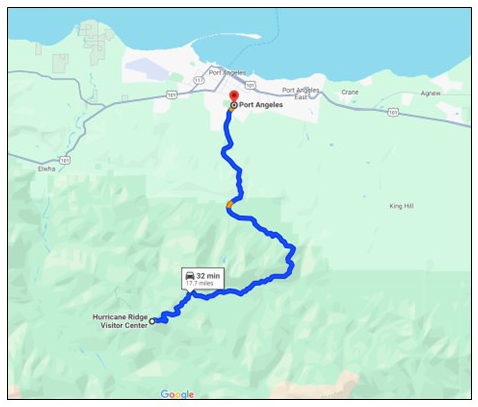
Hurricane Ridge Road
- Northern Terminus: Olympic Park Visitor Center in Port Angeles, WA
- Southern Terminus: Hurricane Ridge Visitor Center
- Road: Hurricane Ridge Road
- Distance: 17 miles
- Designation: Butler Maps G1 Series Route, National Park Service Roads (fees involved)
- First Ride: Aug 2022 on 2022 H-D Heritage
- Synopsis: Two-lane ride along ridgeline in Olympic National Park with “tunnels, tight curves, rapid elevation changes, breathtaking scenery and drop offs with no guardrails.” Nearly 6,000 ft elevation change provides as much of a thrilling ride on the descent from the Visitor Center at the summit as it does on the climb to it.
- Personal Highlights: Numerous overlooks and spectacular views of the surrounding Olympic Mountains (photo), Vancouver Island, Puget Sound and Seattle

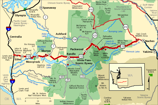
White Pass Scenic Byway
- Western Terminus: Intersection of I-5 and US-12 near Ethel, WA
- Eastern Terminus: Naches, WA
- Road: US-12
- Distance: 120 miles
- Designation: National Scenic Byway
- First Ride: Aug 2022 on 2022 H-D Heritage
- Synopsis: Four- and two-lane highway traversing the diverse ecosystems across much of the state, from long straightaways across the east’s semi-arid climate through fruit orchards, to twisties and hairpin turns through the Cascade Mountain Range
- Personal Highlights: Roadside apple orchards, Rainier Viewpoint (photo) and side trip to Mount Rainier Natl Park and Paradise Road
WEST VIRGINIA

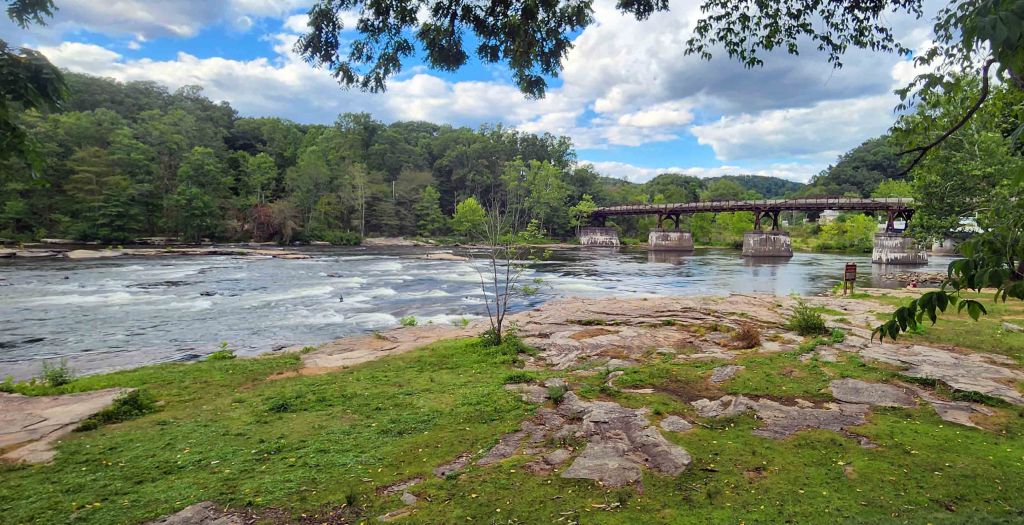
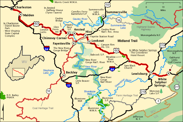
Midland Trail
- Western Terminus: Charleston, WV
- Eastern Terminus: White Sulphur Springs, WV
- Road: US-60
- Distance: 117 miles
- Designation: National Scenic Byway
- First Ride: Sep 2021 on 2012 H-D Streetglide
- Synopsis: Federal highway with twisties and sweepers through the white-water mountain country of the Kanawha and New Rivers, including a national and state park
- Personal highlights: Twisty, steep road down to the bottom of gorge in New River Gorge Natl Park (photo), Hawks Nest State Park, Glen Ferris Inn, coal country, and Kanawha Falls
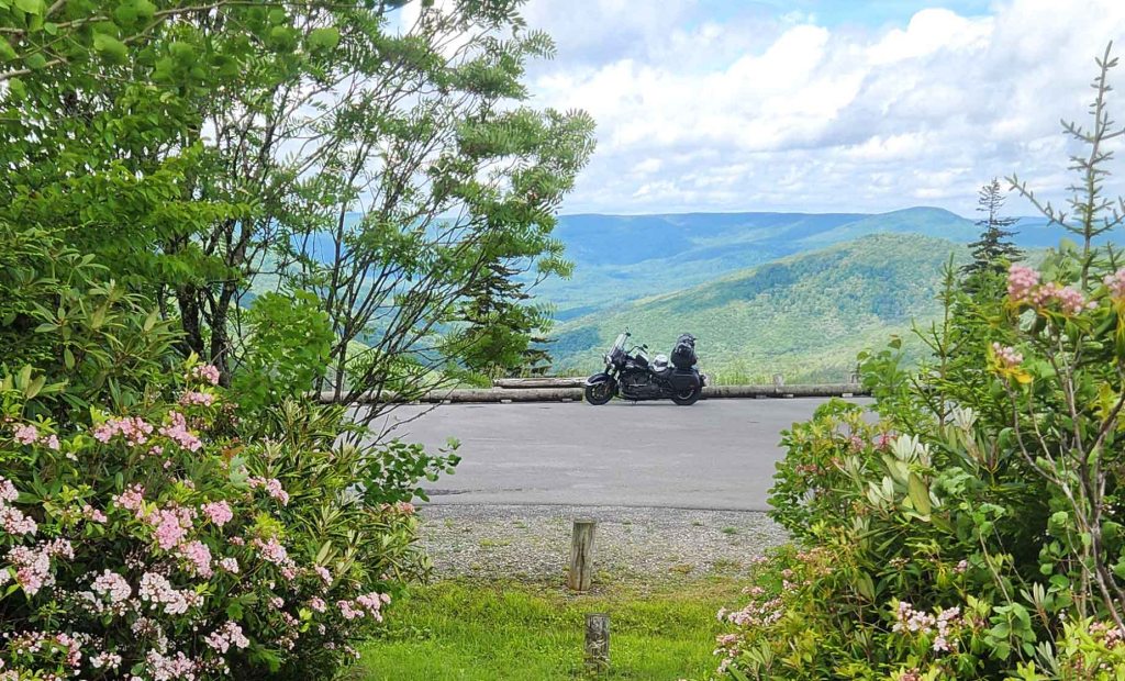
Highland Scenic Highway
- Western Terminus: Fenwick, WV
- Eastern Terminus: Intersection of WV-150 and US-219 approx. 7 miles north of Marlinton, WV
- Road: WV-39, WV-150
- Distance: 43 miles
- Designation: National Scenic Byway and HOG 50 Rides 1 Nation
- First Ride: Jun 2025 on 2022 H-D Heritage
- Synopsis: Two-lane state roads through rolling, mountainous terrain in the Monongahela National Forest, with clear views of mountain valleys and streams
- Personal highlights: Mountain Laurel blooms at Williams Valley Scenic Overlook (photo), Cranberry Glades Botanical Area and Summit Lake

WISCONSIN

Wisconsin Lake Superior Scenic Byway
- Northern Terminus: Cloverland, WI
- Southern Terminus: Northern Great Lakes Visitors Center approx. 4.5 miles west of Ashland, WI
- Roads: WI-14, US-2
- Distance: 70 miles
- First Ride: Jul 2022 on 2012 H-D Streetglide
- Designation: National Scenic Byway
- Synopsis: Easy ride through numerous national and state forests/ natural areas, farm fields, historic towns with quaint cottages, brown sand beaches, and picturesque harbors
- Personal Highlights: Apostle Islands Natl Seashore, Bark Point, and Frog Bay Tribal Natl Park (photo)

WYOMING
I’ve ridden through Wyoming, in transit to another state, but haven’t ridden any noteworthy routes yet.
Road Designations
- National Scenic Byway: A roadway that meets the criteria for at least one of six “intrinsic qualities”: archeological, cultural, historic, natural, recreational, and scenic. The features contributing to the distinctive characteristics of the corridor’s intrinsic quality are recognized throughout the region and are considered regionally significant.
- All-American Road: A roadway that meets criteria for at least two intrinsic qualities that are nationally significant and have one-of-a-kind features that do not exist elsewhere. The road or highway must also be considered a “destination unto itself.” That is, the road must provide an exceptional traveling experience so recognized by travelers that they would make a drive along the highway a primary reason for their trip.
- National Park Service Parkway: A nationally significant roadway, and the parkland paralleling the roadway, intended for scenic motoring along a protected corridor and often connect cultural sites.
- State Scenic Byway: Varies by state, but the commonalities include a roadway to experience a state’s history, geography, culture and natural resources while simultaneously raising awareness for the protection and preservation of these resources
- National Park Service Drives, Highways and Roads: Specially designed transportation routes that travel through National Park Service Units to provide viewpoints of natural and cultural highlights
- Butler Maps G1 Series Route: Paved road segments in America that are dramatic and exciting, featuring steep climbs, tight switchbacks, deep canyons and million dollar views.
- HOG 50 Rides 1 Nation: Scenic and iconic motorcycle routes designated by the Harley Owners Group (HOG) as rides of a lifetime in each state for their “50 Rides 1 Nation” challenge
- Local Favorites: Recommended by local resident riders or on region/area specific websites.
Ride Description Definitions
- Corkscrews: curves that make tight 360 degree turns; requires a fair amount of technical ability
- Hairpin Turns/ Switchbacks: bends in the road that require making a tight turn of about 180 degrees (resembles the curved tip of a hairpin/bobby pin), typically on an ascent or descent ; requires a fair bit of technical riding ability
- Sweepers: gradual curves that don’t require much deceleration; especially fun when the curves alternate between sweeping left and right; doesn’t require much technical ability and allows you to sightsee a bit while riding
- Twisties: sharp bends and corners that typically follow river, mountain, or other terrain features; lots of fun for skilled riders; requires well timed, frequent shifting for acceleration and deceleration

Leave a comment